Friday 28 June 2019

28 June 2019 - Walk: Exwick, Exeter (5.2 Miles)

Synopsis: How could this be? A Valley Park, Whitycombe, here in the city of Exeter, that I had not previously known of until a free paper came through my door. This was my discovery day.
 
GPS Tracklog Download (.gpx) Microsoft OneDrive -:- Google Drive
20190628_130056 - Whitycombe Valley Park, Exeter 20190628_135652 - Whitycombe Valley Park, Exeter 20190628_143302 - Whitycombe Valley Park, Exeter 20190628_153435 - Wildflower, Fox & Cubs, Exeter 20190628_155033 - Exwick Cemetery, Exeter
(selection of photos from Flickr photo album – use link above to view album)

20190628_130258 - Whitycombe Valley Park, Exeter
I cycled from home to Exwick Cemetery where I parked my bicycle. I then walked through the Exwick suburb, eventually climbing through the estate until I reached a stile leading into Whitycombe Valley Park.

A little way into the park I came upon a clump of trees offering shade, under which I sat to eat my picnic lunch. Afterwards, I circled the small park, and then descended into Exwick suburb once again.
20190628_150806 - Barley Valley Park, Exeter
I completed a short circuit through the urban landscape of Exwick suburb. A circuitous route is necessary as a direct approach across fields is not a public right-of-way. Following a lane from Nadderwater, I reached a stile that led into Barley Valley Park, from which this photo is taken.

I sat a while admiring this magnificent view over the city of Exeter, a favourite spot of mine. From here, it was only a short return walk to where my bicycle was parked.

The free newspaper that I mentioned in the synopsis above, that makes reference to the six Valley Parks to be found in Exeter, is the Exeter Citizen - Summer 2019 edition. For further information on the Valley Parks, see: Exeter Valley Parks [Devon Wildlife Trust]. I've copied the Exeter Valley Parks map from this web page into my Flickr photo album for this day, web link to which is given above.

Walk Statistics:

Total Distance: 8.5 km / 5.2 miles
Moving Time: 2hrs 41min
Stopped Time: 45min
Total Ascent: 259 metres
Maximum Elevation: 114 metres

Buses: (none) - Cycled to walk start point at Exwick Cemetery, Exeter


Wednesday 22 August 2018

22 August – 26 November 2018 – Trip to Germany visiting Helen and Laura

Synopsis: Time spent in Germany with Helen, Laura, Uwe, Simon, and other family & friends. Locations around Geislingen, Altbach and Göppingen. Days out with grandchildren and in the great outdoors.

 
IMG_5979IMG_5992WP_20180918_12_17_43_ProIMG_6252IMG_6338WP_20181105_16_08_00_Pro
(selection of photos from Flickr photo album – use link above to view album)

My daughter Helen and family stayed with me for three weeks in August. They returned to Germany in their car. I followed a few days later, on 22nd August, flying to Stuttgart. I stayed for three months, during which time my second grandchild, Niclas, was born to Laura and Uwe. This is a brief summary of a few of my activities during my stay.

27/08/2018: Helen and I walked the Löwenpfad "Geislinger Felsen-Tour" route today. Helen drove us the short distance from home in Geislingen to a start point near Helfenstein castle ruin where she parked the car. We soon reached Bismarckfelsen, a rock outcrop with fantastic views over the town of Geislingen. A steep drop into the valley and up the other side took us to Anwandfelsen, another rock outcrop with views, where we stopped for lunch. This photo shows us entering a steep-sided gorge named the Romantische Felsental [Romantic Rock Valley] near Eybach.

IMG_5996
Walk: Schwäbisch Gmünd, with Helen


03/09/2018: Helen and I started out in the afternoon on this day. We first did a walk around Adelberg lake, a favourite haunt of ours. And then Helen drove us over to nearby Schwäbisch Gmünd, where we walked around the old quarter of the town.

Schwäbisch Gmünd is very picturesque, as can be seen from this photo, taken in the main town square. A children’s sandpit play area had been created here. This outshone something similar created in Göppingen.

IMG_6045
Göppingen Stadtfest - Saturday-Sunday, 8th-9th September 2018. Stand: Helen Doron, English Language School, Goppingen, managed by Sylvia Martin


09/09/2018: Today, Sunday, we all mucked in and helped out with the Helen Doron stand at the annual Göppingen Stadtfest. The weather was glorious, hot and sunny, and the crowds were out in force. Helen was one of the face-paint helpers, and was kept busy all day long. I was taking photos, shooting video and blowing up balloons. Later in the afternoon the children attending the school, along with Sylvie and Helen, would put on a short song and music performance in the town square.

We finished the day with pizza and cake back at the Helen Doron school. A tiring day, but lots of fun.


18/09/2018: The panorama below was taken on a cycle ride I undertook from the Westerheim camp site where I was kindly allowed to stay in Laura and Uwe’s caravan. The photo is taken from Raussenstein, a castle ruin dramatically perched atop a rock pinnacle. The views from here are amazing!

WP_20180918_12_32_49_Panorama_stitch
Cycle Ride: Westerheim to Raussenstein and Romerstein. This panorama is the view from Raussenstein.
WP_20180928_14_16_06_Panorama
Walk: Löwenpfade 'Wasserberg-Runde'" - [Löwenpfade]

28/09/2018: Cycling a short distance of about 6 Kms from Geislingen I was able to reach Hausen where I parked my bike, making this the start point for my walk today. The photo here, taken well into my walk, shows a scene typical for this area. The hills rise steeply to plateaus all of which are of similar altitude. The valleys are like little oasis snugly encircled by these hills.

Note: I, once again, followed a designated walk route, link given in the description to this photo.


29/09/2018: I had some time to myself in the afternoon on this day, so I decided to walk up Bismarckfelsen once again. I discovered, looking at maps, a reasonably direct route from the town centre of Geislingen. Geislingen is nestled in tightly between a number of hills.

WP_20180929_17_25_47_Pro_stitch
Walk: Geislingen, Bismarckfelsen. Panoramic view of Geislingen from the Bismarckfelsen rock outcrop.

14/10/2018: A family outing, Helen, Simon, Liam, Little Helen, and myself, on a trip to Ludwigsburg to visit the Pumpkin Festival. It is said that this is the biggest pumpkin festival in the world. I can believe it. One would not have thought that pumpkins came in so many shapes, sizes and colours until one sees the pumpkins on display at this festival. There are also pumpkin animal sculptures like the one photographed here. There are also sand sculptures. It was a fun day out, at an event that was extremely popular.


WP_20181117_15_44_22_Pro
Cycle: Geislingen to Wasserberg Haus

17/11/2018: The weather was bright and sunny, and Helen, Simon and I were looking for something to do as afternoon came on. I suggested we might cycle to the Wasserberg Haus. I’d felt slightly cheated when having walked the Wasserberg-Runde (mentioned above), and not having come across this place. It was a bit of a climb out of Reichenbach im Täle, but once on the hillside, the cycling was easy and enjoyable. Sadly the place had been shut-up for a couple of weeks, so there was no tea and cake for us, which would have been welcome.

Finally, come 26th November, having just had my birthday in Germany for the first time, I was due to return home. The weather during my stay had been so kind, and everyone had been so welcoming. This had been my longest stay in Germany, at just over three months. I had had such a great time, but felt duty-bound to return home. I travelled home in the sure knowledge it wouldn’t be so very long before I returned to Germany.

P.S. My sports activity stats for 2018:

Runtastic Stats for Year 2018
[Runtastic Stats for Year 2018]: A good year for consistent physical activity! (Fitness Profile)

This shows my Runtastic stats as at the end of 2018, my fifth year of using the Runtastic app to record activities in my fitness regime. The four activities shown here are the primary activities that I like to keep track of. I also play badminton over the winter period. My two priority targets are 400 Kms for Running, and 2,000 Kms for cycling. I was particularly pleased with my 53 Kms of swimming this year, helped by my stay on the Alb Camping site, at Westerheim. I shall also make 50 Kms my annual swimming target n future.

Saturday 14 July 2018

14 July 2018 - Walk: Whiddon Down to Castle Drogo (NT) (10.3 Miles)

Synopsis: Travelled by bus from Exeter for walk Whiddon Down to Castle Drogo (NT). Easy walking through superb scenery. The gardens at Castle Drogo were spectacular. A brief castle visit included.

GPS Tracklog Download (.gpx) Microsoft OneDrive -:- Google Drive


Whiddon Down to Castle Drogo (NT) 047Whiddon Down to Castle Drogo (NT) 053Whiddon Down to Castle Drogo (NT) 066Whiddon Down to Castle Drogo (NT) 072Whiddon Down to Castle Drogo (NT) 074Whiddon Down to Castle Drogo (NT) 093
(selection of photos from Flickr photo album – use link above to view album)

Inspiration for this walk came to me upon discovering how useful the Stagecoach ‘6’ bus route was to me when used on my 17 May 2018 - Walk: East Week, to Throwleigh, and then Cosdon Beacon (9.3 Miles) [My post on Blogger]. This bus route skirts Dartmoor, is a rapid journey, and what’s more, can be used on an Exeter Day Rider Plus ticket at great value (see details below). I’d mapped this walk route sometime previously and had it in the can ready for use once the opportunity arose, and that was to be today.

Whiddon Down to Castle Drogo (NT) 002
Whiddon Down [Wikipedia] - 'Village Hall' bus stop, Whiddon Down

An objective for me today was to explore a length of the River Teign just above Castle Drogo (NT) which, rather surprisingly considering how many times I’d visited the lower Teign Gorge [National Trust] area, I’d not previously explored. My bus drop-off was at Whiddon Down, which I reached at 08:40 (50 minute journey). The countryside on the route out looked summery, but parched. This early in the day, the air was refreshing, although already warming fast.

Whiddon Down to Castle Drogo (NT) 010
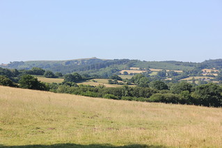
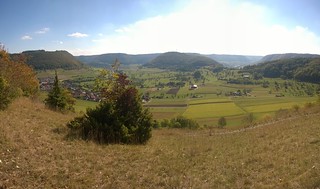
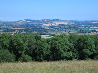
Looking towards Dartmoor which was not so very far away


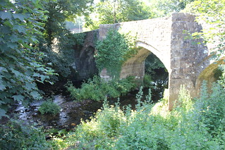
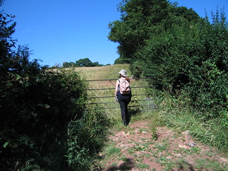
Initially the walk was largely along quiet country lanes, with excellent views out to Dartmoor, not far in the distance. I followed a public footpath across a field to reach the tiny village of Murchington. From here the path dropped into trees to pick up the course of a tributary that led me down to the River Teign at Chagford Bridge, not entirely surprisingly, near to the village of Chagford, which I did not enter today.

Whiddon Down to Castle Drogo (NT) 030
Chagford Bridge (Listed Grade II*) [Historic England List]


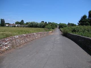
The Chagford Bridge we see today is thought to be 16th century. A bridge was mentioned at this crossing in 1224. Countless numbers of people have passed this way through the ages. The bridge is quite narrow, so its safe to say coaches won’t be crossing here.

Whiddon Down to Castle Drogo (NT) 040
Rushford Mill [Legendary Dartmoor] Farm.


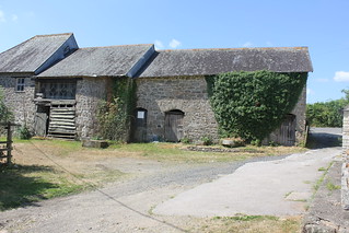
Half-way between Chagford Bridge and Dogmarsh Bridge there’s a short stretch of lane walking until Rushford Mill [Legendary Dartmoor] is reached. There are some lovely old postcards of Rushford Mill as it once was on the Legendary Dartmoor web site (follow the link to view).

Whiddon Down to Castle Drogo (NT) 042
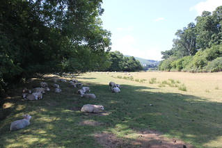
'Sheep may safely graze' ... Or, in this case, sheep may safely doze in the shade of this tree on the banks of the River Teign [Wikipedia].

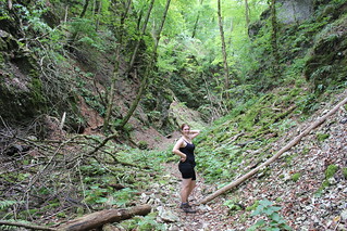
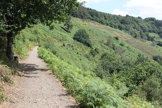
From Chagford Bridge, all the way to the footbridge over the River Teign just below Hunter’s Tor, the walking was lovely and easy, never that far from the course of the river. Occasionally there was a little shade on offer, something much appreciated by the sheep I passed, who seemed to be suffering rather from the heat. They were very relaxed about me wandering close by, hardly bothering to shift, which isn’t typical behaviour, as normally they’re very skittish.


Whiddon Down to Castle Drogo (NT) 060
Just below Hunter's Tor, on the western side of Teign Gorge [National Trust].


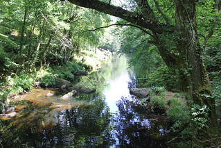
The footbridge below Hunter’s Tor marks the western end of the Teign Gorge, with Fingle Bridge at the eastern end. It’s a lovely spot, one of my favourites. The tree cover in the steeply sided gorge creates a lovely cool light, a welcome contrast to the bright heat of the day. Even after this hot spell, there was a good flow of water in the river. The fish were however finding it too warm, and occasionally jumped for air.

Whiddon Down to Castle Drogo (NT) 065
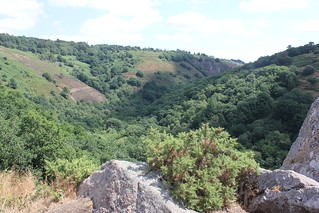
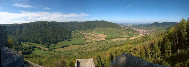
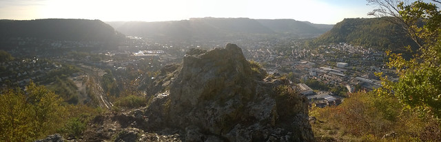
Hunter's Tor, just below Castle Drogo. View looking east along the length of the Teign Gorge [National Trust].


My chosen walk route from here was straight up Hunter’s Tor, which is quite steep, and a bit of a scramble. There’s an easier gentle track should that be more suitable. The views from Hunter’s Tor are a treat. In one direction one looks out to Dartmoor, where I was walking in May of this year (link above). In the other direction I looked along the Teign Gorge. And a short distance away, slightly above me, stood Castle Drogo.

Whiddon Down to Castle Drogo (NT) 067
Hunter's Path, on the Teign Gorge Classic Circuit [National Trust]


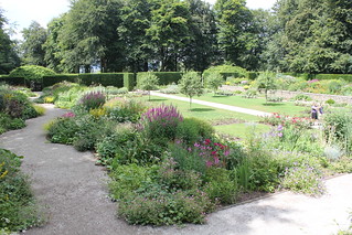
My objective now was lunch in the gardens of Castle Drogo. I followed what is named Hunter’s Path, which follows the contours of the hillside to a point just below Castle Drogo reception. As I entered (I’m a member of the National Trust), I enquired about the immense conservation project, now in its sixth year. Apparently it is well advanced, and completion is expected later this year. I sought out a shady bench in the formal garden upon which to eat my picnic lunch.

Whiddon Down to Castle Drogo (NT) 069
[Castle Drogo [National Trust]]: The Garden at Castle Drogo [National Trust]


I could see from where I sat eating my lunch that the gardens at Castle Drogo were looking amazing. I do love gardens, and now was the zenith of their prime season. I took a stroll. What has been achieved here at the centre of the formal garden of Castle Drogo is great swathes of colour swatches at varying heights and set against a perimeter of dark yew hedging. In the centre is a lawn rigidly interspersed with rose beds.

Whiddon Down to Castle Drogo (NT) 081


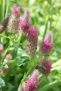
A less formal woodland garden leads off above the formal garden, and above that is the croquet lawn. A gardener’s hut is located here, and inside are displays identifying many of the plants to be found here, and old photos showing how the garden was planned and developed. There is a blue theme to much of the planting. But, just to be perverse, as is my wont, I'm choosing this Red Feather Clover as my plant of the day. Who'd have thought clover could look so spectacular?
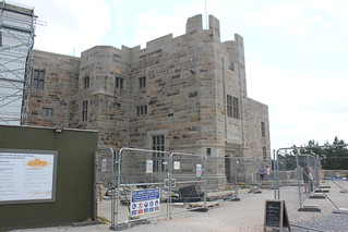


Whiddon Down to Castle Drogo (NT) 090
[Castle Drogo [National Trust]]: … The entrance to the castle where conservation work has been (almost) completed.


For the duration of the conservation work on Castle Drogo, now in its sixth and final year, I had been mostly bypassing the building, focussing on the gardens and the surrounding landscape, which has so much to offer. The works on the castle have been very extensive, effectively a dismantling and rebuilding, affecting both the exterior and interior of the castle, somewhat negatively impacting the experience of a visit. Today I opted for a brief castle visit.
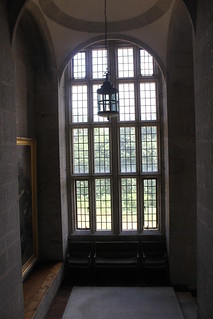
Whiddon Down to Castle Drogo (NT) 091
[Castle Drogo [National Trust]]: … The fine proportions and elegance of the brass windows.


One of the features I like about the castle is its windows. They are very large and elegant. I talked to a steward about them. They have been taken out, re-glazed, and set back in their frames, in the expectation that they will now provide  a more effective barrier against the driving rains encroaching from Dartmoor. They are, apparently, made of brass, which accounts for the excellent working condition of them, even after all this time. The windows must surely have cost a packet at the time of initial construction.
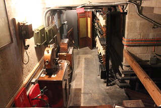


Whiddon Down to Castle Drogo (NT) 094
[Castle Drogo [National Trust]]: … If the Pantry is the 'Control Centre' of the house, then this has be the 'Engine Room'. Officially referred to as 'The Switch Room'.

I had a particular wish to seek out the old switch room. Castle Drogo had some modern (for its time) creature comforts installed, such as electricity, central heating, and even a shower (see: Castle Drogo (NT) 024 [My photo on Flickr]). In October of last year, I passed the hydroelectric installation, recently refurbished by the National Trust (see: 14 October 2017 - Walk: Castle Drogo (NT) to Cheriton Bishop (9.4 Miles) [My post on Blogger]). An almost inaudible hum from the Hydro Turbine House [National Trust] on the river bank could be heard emanating from it. New cables could be seen feeding electricity back up the hillside to the castle, capable of supplying half of its energy requirement. And here in the castle itself, the old Switch Room complete with its original installation can be seen still in place. It’s a little time-warp, and yet how modern to have been so sustainable back then.
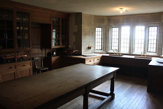
Whiddon Down to Castle Drogo (NT) 092
[Castle Drogo [National Trust]]: … The Pantry. A delightful room. One can imagine the servants gathered here, waiting for the beck and call of the masters of the house, relayed to them here, in the nerve centre of the house

Castle Drogo is a wildly romantic and delightful enigma. What were they thinking? building a ‘castle’ at this time. A case of, ‘We’ve got the money, let’s have fun.’ And they got so much right in their blend of the old and the new. What a fabulous location! Self-sufficient in electricity, with telephones, showers and central heating. Designed by a leading architect of the age. Added to this, a garden of fine taste. It’s my belief that only now has Castle Drogo come of age. The technologies of the time of construction were not sufficient to match the imagining. Today we have the required technology. Put together well the dream and the technology, and what you get is the Castle Drogo that we have today. A conservation project of breath-taking scale and complexity; I applaud the National Trust for their determination and nerve. The result will assuredly please countless generations. It’s comforting to think so much of our heritage is in such safe hands.
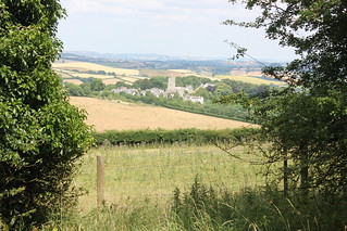
Whiddon Down to Castle Drogo (NT) 098
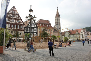
[Castle Drogo [National Trust]]: … From the drive of Castle Drogo, a glimpse of Drewsteignton and its church is to be had between the trees.

After my visit to the castle, I checked the time, it was now 14:20, and considered what bus I might catch. It would have be a rush to catch the 15:30, and I wasn’t prepared to rush on as hot a day as today. I settled upon a leisurely pace, with the aim of catching the 16:59 bus. I relaxed on a garden bench, had a drink, took a couple more circuits around the garden paths, and dawdled in the shop. By 15:00 I was strolling down the castle drive.


Whiddon Down to Castle Drogo (NT) 104
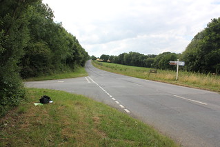
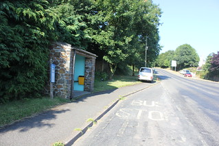
My 'bus stop', Ford House Turn it is named.


I walked down a lane marked ‘Road Closed’ in the hope I could pass. A new fibre optic cable was being laid in the road. This is the bus route I used in October last year, so I’m not sure what’s happening with that just now. I picked up a public footpath which connected me with another lane. It was a short walk, over a bridge on the Fingle Stream just below Ford House, and on an upward climb to where I intersected with my bus route.

By 15:40 I had reached my bus stop, Ford House Turn, which meant I had a 1hr 20mins wait for my bus. I had overestimated the required walk time. I found some shade under a tree and caught up with the news on my mobile phone. My bus was punctual and the journey home efficient. The perfect end to a perfect day’s walking.

Walk Statistics:

Total Distance: 16.55 km / 10.3 miles
Moving Time: 5hrs 46min
Stopped Time: 30min
Total Ascent: 357 metres
Maximum Elevation: 278 metres

Buses: S, 6A, 6 & D
Exeter Dayrider Plus bus ticket: £6.00 (purchased on first bus of the day)

Saturday 7 July 2018

07 July 2018 - Walk: Heavitree Parish Boundary walk (14.3 Miles)

Synopsis: A walk around the Heavitree Parish Boundary seeking marker stones as we went. Five go on a beating the bounds walk. Great views from Stoke Woods. Excellent company. A superb day. Very hot!

GPS Tracklog Download (.gpx) Microsoft OneDrive -:- Google Drive


Heavitree LHS - Beating Bounds 003Heavitree LHS - Beating Bounds 025Heavitree LHS - Beating Bounds 031Heavitree LHS - Beating Bounds 034Heavitree LHS - Beating Bounds 043Heavitree LHS - Beating Bounds 049
(selection of photos from Flickr photo album – use link above to view album)
Heavitree LHS - Beating Bounds 002
The strolling players from the Heavitree Local History Society [Official web site] for today's Heavitree Parish Boundary Walk- marker stone No. 1 of 10

Five plus one actually. This organised walk by the Heavitree Local History Society came as rather a surprise to me, as my understanding was it is normally undertaken on a 3-year cycle, and I was aware it had been walked last year. I spotted it on the group’s web site, and thought I’d like to tag along, if they’d have me. The society members participating in the walk welcomed me to their party at the Livery Dole start point, adjacent to the first boundary marker - marker stone No. 1 of 10


Heavitree LHS - Beating Bounds 004
Heavitree Parish Boundary - marker stone No. 2 of 10


The idea of the walk is to follow the Heavitree Parish boundary reasonably closely, and visit each of the 10 remaining boundary markers still in place. A number of the markers have an interesting reclamation story behind them, such as this one in Polsloe Road. Terry saw it discarded on a pile of rubble beside the road and organised it’s replacement here by a road crossing.


Heavitree LHS - Beating Bounds 007
Heavitree Parish Boundary - marker stone No. 3 of 10


Heavitree is a large parish, and correspondingly, the boundary is lengthy. Today’s walk, for those doing the complete circuit, would be over 14 miles. Some in the party would be opting to do half today, and complete the other half next week. We passed the old Female Reformatory [Old-Maps - 1891 1:500 scale] in Polsloe Road, crossed at the busy Mount Pleasant junction, and followed the Mount Pleasant Road to the junction with Old Tiverton Road. Here the next boundary stone was found smack bang in the middle of the road.

Heavitree LHS - Beating Bounds 008
Heavitree Parish Boundary - marker stone No. 4 of 10


We then headed up Rosebarn Lane to the very top of the hill, where the next boundary marker stone was to be found, after a little ferreting in the hedge. Mike came prepared, and with secateurs to hand, cleared some of the vegetation so that we could see the marker stone.


Heavitree LHS - Beating Bounds 013
The site of an old Roman Fort at the top of Stoke hill.


We followed Pennsylvania Road for a short distance before detouring right on to a dirt track with a tunnel hedge providing some welcome shade from the relentless sun. We were soon at Stoke Hill Camp [Historic England List], and old Roman signal station. Nothing significant remains on the surface today, but it was pleasing to reflect on the camp’s past.

Heavitree LHS - Beating Bounds 021
The view from Stoke Woods looking north, Brampford Speke visible in the middle distance.


It wasn’t long before we reached a farm where we connected with a footpath. From here we headed right. This next stretch offered some of the finest views of the walk. It was possible to see for miles. In the landscape it was easy to identify Brampford Speke and Stoke Canon. And in the further distance the mound known as the Killerton Clump [National Trust] was very recognisable. This, perhaps rather surprisingly, is an extinct volcano.

Heavitree LHS - Beating Bounds 026
Fantastic view out over Exeter. Exeter Cathedral just visible behind the John Lewis building.


We continued on in this general direction until we connected with Stoke Hill Lane, where we branched right. We eventually connected with Mile Lane, a dirt track running off to the left. From the intersection there was a terrific view out over the city, one of the best I’ve ever come across. Exeter Cathedral could just be made out behind the John Lewis building.

Heavitree LHS - Beating Bounds 028
Mincinglake Valley Park [ECC] Refreshment stop.


For a while we detoured into the Mincinglake Valley Park [ECC], simply because the walking was more pleasant than that of Mile Lane. We stopped briefly for refreshment. Continuing on, we connected with Beacon Heath Road, turned left, and walked as far as a park, Exhibition Fields, on the right. We walked through this park and then on to Pinhoe Road.

Heavitree LHS - Beating Bounds 030
Heavitree Parish Boundary - marker stone No. 5 of 10


This is where we came upon the next parish boundary marker, beside this busy road. I lived in Pinhoe once, and must have cycled past this marker stone hundreds of times without realising it was there. Crossing the road we found ourselves in yet another park in which we found some shade under trees to sit and eat our picnic lunches.

We noticed a new pub established nearby, The Pinhoe Hoard [Marston’s], and wondered at the naming. Apparently it honours the discovery of Bronze Age artefacts discovered in 1999 by Jim Cobley [Historic Environment – DCC] (how Devonshire is that?).

Heavitree LHS - Beating Bounds 032
Heavitree Parish Boundary - marker stone No. 6 of 10


After lunch we walked on until we picked up Pinn Lane. This is much changed from when I lived in Pinhoe, with business offices and residential developments now all around in what was once just a country lane. The next boundary marker was found where this lane connected with the extremely busy Honiton Road. Once again, this was a marker stone on the verge of oblivion when reclaimed by Terry.


Heavitree LHS - Beating Bounds 040
Heavitree Parish Boundary - marker stone No. 7 of 10. Marker sited on the medieval bridge and causeway at Clyst St Mary


The group split at this point, with those doing half the walk today leaving us foolhardy few doing the full distance, Sally, Jonathan and myself. A little bit of busy street walking was now required to get us to the next marker stone, perhaps the one most unusually sited. It stands against the parapet of Clyst St Mary Bridge and Causeway [Historic England List], a listed monument. Despite the hurly burly all around, this is a great survivor, and I always like to see it. The route is originally Roman, the bridge medieval.

Heavitree LHS - Beating Bounds 042
Heavitree Parish Boundary - marker stone No. 8 of 10. It's got to be in here somewhere!


Sally was running short on drink, so we walked into Clyst St Mary to find the convenience store at which to top up our supplies. A chilled drink was most welcome.

It wasn’t a great distance from here to our next marker stone, once again almost hidden in the vegetation of the hedge. The fact that the marker stone’s position is next to a modern road sign increased our chances of finding it.


Heavitree LHS - Beating Bounds 046
Heavitree Parish Boundary - marker stone No. 9 of 10


We had quite a walk ahead of us to reach our next marker stone, a good deal of which was road walking. We crossed the busy Bridge Road using the pedestrian bridge, and then walked through the King George V Playing Fields. We were headed for the mill race known as St Jame’s Leat that once fed the old paper mill at Countess Wear. We cut in at Matford Lane, eventually reaching Magdalene Road, where our next marker stone was found. Sunk deep in the ground, only the top part of the stone is now visible.

Heavitree LHS - Beating Bounds 051
Heavitree Parish Boundary - marker stone No. 10 of 10


We cut through the grounds of St Luke’s College making our way to Heavitree Road where we found the last of the set of boundary maker stones, sited against the wall of a staff building attached to the St Luke’s complex. The marker stone did look a little forlorn, but at least it was there making a stance after all this time.

Heavitree LHS - Beating Bounds 052
Styrax Obassia - [Wikipedia] tree in Heavitree had come into flower


A short stroll to the top of the hill took us back to our start point of Livery Dole. It had been an extremely interesting day, and I felt walking the boundary was a great thing to have done. The day had been made all the more enjoyable by the delightful company of those on the walk party today. As we merry three wended our way homewards, I happened to notice the Styrax Obassia tree was in bloom, and how pretty it looked too.


P.S. The ‘Tracklog and Photos - Google My Map’ link at the top of this blog post presents outlines drawn on this map of both the Heavitree Parish Boundary and the Heavitree and Whipton Barton Ward. The Heavitree Parish Boundary is based upon information obtained from the Heavitree Local History Society web site. The outline of the Heavitree and Whipton Barton Ward is based upon information obtained from the Devon County Council web site. The map I have supplied contains web links to the source information that I used when compiling my map.

An impression of the weather today, and this summer, from news articles:

Heatwave unveils ancient settlements – BBC News 07/07/2018
UK heatwave: Hidden landscapes the heatwave is revealing – BBC News 17/07/2018
Lake District village ruins revealed by water shortage – BBC News 18/07/2018
The dramatic effect of the UK heatwave – BBC News 19/07/2018
UK weather: Driest start to summer on modern record – BBC News 20/07/2018
UK Heatwave 2018: The winners and losers – BBC News 21/07/2018
UK heatwave: Met Office says 'stay out of the sun' – BBC News 23/07/2018
The dried parks and parched lawns of Britain [In Pictures] – BBC News 23/07/2018
UK heatwave: Temperatures set to rise as alert continues – BBC News 24/07/2018
Hot Dry Summer Reveals Hidden Archaeological Sites in England – Historic England 15/08/2018

Walk Statistics:

Total Distance: 23.28 km / 14.3 miles
Moving Time: 5hrs 39min
Stopped Time: 1hr 50min
Total Ascent: 438 metres
Maximum Elevation: 165 metres

Buses: (none)