Saturday 19 September 2015

19 September 2015 – Trip: Maker Heights Barracks, Kingsand, and Cawsand with Mum

Synopsis: Trip inspired by desire to take a look around Maker Heights Barracks, a school camp of my father’s in the 1930s. Includes a ferry journey from Cawsand to the Barbican, Plymouth. Great day!

 
Maker Heights 007Kingsand 001Cawsand 004Cawsand 005Cawsand 015Plymouth 012
(selection of photos from Flickr photo set – use link above to view album)

This was a fairly early start for Mum and me. We were travelling by train to Plymouth from our local Digby & Sowton rail station. Our trains down, and in fact all the trains, buses and ferry today, were very punctual. Arriving in Plymouth, we had an hour and ten minutes to spare before our bus was due, so we sought out the station café for tea and a muffin.

We caught our bus just outside Plymouth rail station. It took us through part of Plymouth before dropping down to the Torpoint ferry. The ferry took us across the River Tamar to Saltash, in Cornwall, across the border and into the wilds. Slowly the bus climbed through the streets of Saltash, out into the countryside, before swooping south down to the coast. This next stretch of our journey was one of our day’s ‘bonus’ sections. We peered out on the broad sweep of Whitsand Bay, and in the distance we could see the headland of Rame Head with its little chapel. Shown below, alongside the photo of Mum on the bus, is an historic photo showing a few of the holiday chalets that dot the steep-sided shore of Whitsand Bay.

Cawsand, Rame Head c.1955
Cawsand, Rame Head c.1955 - © Francis Frith
WP_20150919_11_18_56_Pro
[Whitsand Bay]: On the bus, travelling from Plymouth to Maker Heights
Maker Heights 001
[Maker Heights]: At the entrance to the track, which leads to Maker Heights Barracks, there is this fabulous view out over Millbrook

The bus then dropped towards Cawsand and Kingsand, but rather than leave the bus at this point, Mum and I stayed on board. The bus took us out to Millbrook and back, before climbing the hill to Maker Heights, which was our chosen bus stop. At this point, on the junction with Maker Lane, there is this superb view out over Millbrook.

Mum and I then proceeded along the track which led us in the direction of Maker Barracks. That’s what it continues to be named on the map, although it has long since ceased to be a barracks. It is today known as Maker Heights Centre.


I noticed an array of Nissen Huts on our left as we approached Maker Heights Barracks. I wonder if this might have been where Dad was billeted on summer camps from Central School, Exeter. I wasn’t sure when Nissen huts came into being, but on looking this up (where would we be without Wikipedia?), I find that these were ‘originally designed during World War I. This makes it possible that the huts we saw today were in place in 1930, and could have been the school summer camp. They don’t seem to have much in the way of windows.

Maker Heights 005
[Maker Heights]: Barrack Block


The ‘Guard House, Boundary Wall and Attached Ancillary Buildings’ and the ‘Barrack Block’, at Maker Heights Barracks, are both Grade II* Listed, which signifies that they are deemed to be of some considerable importance. The Barrack Block is described in its listings as, ‘This is the most complete and unaltered example in England of a small garrison barracks from this significant period, and includes many of the ancillary buildings within a defensible site.’

Maker Heights 016
[Maker Heights]: Barrack Block


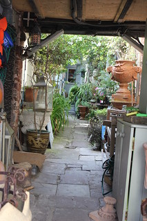
I believe the buildings sat derelict and disused for a long time, and the hope was always to find a use for them, to bring in some money to help with the upkeep of the buildings. I noticed a number of art galleries had moved in, and that generally things were looking pretty good. There wasn’t the complete air of abandonment I was half expecting.


At the back of the main Barrack Block, along the north-east wall, there exists the former straw store, wash house, stables, gun shed and magazine. The fact that the site is so complete, with all these out buildings remaining, makes this a treasure of a historic survivor.

Maker Heights 011
[Maker Heights]: Exterior steps to the upper floor of the Barrack Block


I believe the main building we see today is the Barrack Block. And I think the way we see it today isn’t far removed from how it has always looked, which is refreshing, particularly in this age of the ‘make-over’. I believe the buildings are of early to mid nineteenth century construction. To the rear of the Barrack Block there are external steps, which appear to be original, leading to the upper floor of the building.

To the north-east of the Barrack Block is to be found the Guard House. This is now in use as an art gallery. Beside it, to the south-east, there is a rather primitive looking toilet block. I think this could be as far as it goes as regards campsite facilities. But then, this is described as ‘camping as it should be’, and when one sees the glorious position of the site, it’s easy to see their point.

The Maker Heights Barracks seems to operate today under the banner, Maker Festival & Maker Camps, and has its own web site.


Maker Heights 022
[Maker Heights]: Guard House, Boundary Wall and Attached Ancillary Buildings - Coal house and linen store

The lone building to the south-west is described as the coal house and linen store. An odd combination, considering the dust from the coal dust, but probably the building was partitioned. The chimney suggests a fireplace, perhaps to keep the linen aired.

The book Plymouth in the Twenties and Thirties by Chris Robinson speaks (p.139) of ‘School groups also went camping at the old military encampment at Maker with its huts and big green spaces’. This re-enforces the fact that Maker Heights Barracks was definitely a popular school summer camp during the time that my father went on a summer camp here.


Time was marching on, and thoughts of lunch were paramount, so Mum and I walked on, following the track through the camp site, and then beginning to descend off the hilltop. As we went, somewhat shrouded in vegetation, there were what I presume to have been defensive positions dotted on the coastal aspect of the site.

Maker Heights 037_stitch
[Maker Heights]: View from Maker Heights looking out to sea, in the direction of Kingsand and Cawsand. Further evidence of fortifications in the middle distance.

Crossing a lane, we picked up a way that was clearly signposted as a public footpath. This started well enough, but became fairly steep and quite uneven. It was also very enclosed by the high hedgerow, so, in hindsight, I’m not convinced this was necessarily the best route to have taken. I think, given the chance to make this walk again, I’d choose to walk north-east at the lane and pick up a path that would have dropped us down to the coastal path, which goes through what is rather quaintly named Minadew Brakes. I think the going might be easier than the route we chose today, and the views possibly better too.

Cawsand, The Cleave 1949
Cawsand, The Cleave 1949 - © Francis Frith
Kingsand 003
[Kingsand]: Looking east towards Plymouth
Kingsand 005a
[Kingsand]: Lunch at The Devonport Inn - Our lunch of Cumberland sausage and mash

I had checked out possible eating venues in Kingsand before setting off today. There seemed to be a number of favourable possibilities, of which I thought we’d try The Devonport Inn. I’d read that it could get busy, but being down on the seafront, it seemed to have the most enticing views going for it, so I thought it worth a try. As it happened, we immediately found a small table that suited us fine. It wasn’t long before we were tucking into our excellent Cumberland Sausage and Mash. The sun streamed in through the window, there was a buzz of people going to-and-fro, and numerous people were in high spirits, as a wedding seemed to be taking place in the village.

Kingsand 012
[Kingsand]: Rock pools


On finishing our lunches (time at The Devonport Inn 12:55-14:00), we had plenty of time to amble as we pleased, as our ferry from Cawsand to Plymouth was not due until 15:30. We often found ourselves merely leaning on the railings gazing out to sea and generally watching people milling about. It was warm, sunny, and with just a gentle breeze blowing. It couldn’t have been better.

Kingsand 014
[Kingsand]: The 'back yard'


We walked to the eastern edge of Kingsand, the last stretch of which Mum held back from following, as it involved my hopping across rocks. From the furthest point I reached I came upon a sandy stretch of beach with hardly a soul on it. Apparently, each summer, there are erected a number of beach huts located at Sandway Beach, just a little further along the coast towards Picklecombe Fort. I noticed that a number of the properties in Kingsand were for sale, and inviting they looked too. The one pictured here, had the most delightful ‘back yard’.

Kingsand 020
[Kingsand]: The Institute (Grade II Listed)


Mum and I then backtracked past The Devonport Inn once again and into the village centre. We passed the tower which got a heavy battering during the winter storms of 2014. I believe the tower needed considerable repairs and work to protect it, following those storms.


Kingsand 026
[Kingsand]: The old county boundary marker. This once marked the boundary of Devon and Cornwall, with Kingsand once being in Devon


A bit further along, we came upon the Halfway House. And on from that, we saw Boundary House. The preoccupation with place stems from the time when this was the boundary between Devon and Cornwall. At one time Kingsand was in Devon, and Cawsand was in Cornwall. I understand there was considerable rivalry between the two. Whether that persists to this day I do not know.

Kingsand 029
[Kingsand]: The Institute (Grade II Listed) - Looking back towards Kingsand from the promontory between it and Cawsand


A short climb from here and we were at a promontory, buildings all about looking down on the beach at Cawsand. The sea was the most wonderful azure colour. It could have been the Mediterranean. We watched a woman, who was obviously a seasoned swimmer, take her plunge. If I’d had my swimming costume, I could have been tempted. As we watched, we could hear a drumming nearby. Not sure what it was, we approached Cawsand’s village centre.

Cawsand 008
[Cawsand]: Morris dancers putting on a show -:- (Videos)


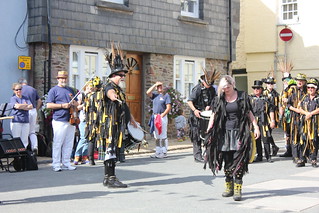
As we dropped down into the centre of Cawsand, all became clear. A large band of raucous Morris Dancers had taken over the village centre, and were entertaining the crowd. Dressed in black, with faces painted black too, they had a rather eerie look to them. But the evident fun the dancers were all having easily quelled any sense of alarm at their appearance. The group were performing in the Square, seen here in 1949.

Cawsand 014
[Cawsand]: The Cawsand Ferry - Mum, waiting for the ferry in the shelter


After watching the Morris Dancers for a while, Mum and I dropped down to Cawsand beach. There is a small shelter on the beach for those waiting for the ferry (The Cawsand Ferry). Hardly in need of a shelter today, Mum and I found ourselves a bench on which to sit. I began to fidget, so I strolled off across the beach and climbed on the rocks at the furthest reach, which proved a good vantage from which to take a few photos.

Cawsand 026
[Cawsand]: The Cawsand Ferry - Passengers from Plymouth disembarking


The time was approaching 15:30, the time our ferry was due, and a tiny red dot appeared on the horizon. Slowly our ferry came into sight. A small queue had formed on the beach, so Mum and I went to join them. It’s not a big ferry, and the rather basic wheeled jetty looked quite flimsy, but with a little help from ship hands, we were all soon boarded.

Plymouth-Cawsand Ferry 015
[Plymouth / Cawsand Ferry]: The coastal fortifications of Drake's Island (Ancient monument)


This was to be another of today’s ‘bonus’ elements on our trip today, as we were to get some fine views of the coast along Cawsand Bay. And we also had our first close-up views of the breakwater at the mouth of Plymouth Sound and Drake’s Island. And in addition to all that, we both had our first sea view of Plymouth Hoe, the Tinside Lido, and the Citadel. It proved a really interesting ferry crossing, and we were so pleased we had made this crossing of the bay by boat.

Plymouth 001
[Plymouth]: The Barbican - Ice cream and tea on the Barbican, from trailer vendor Alfresco


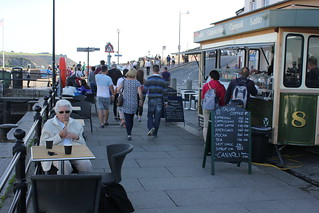
On arriving at the Barbican we sought out a little harbour side vendor selling ice creams and hot tea. We were soon in the possession of a cornet and cup of tea each. We found a table overlooking the marina and sat back and relaxed, and continued our people watching of the day.


Plymouth 007
[Plymouth]: The Barbican - Oldsmobile Super 88 Holiday coupe


Whilst Mum and I sat and ate our ice creams and drank our tea, this most amazing car sailed by. I just had to grab a photo or two. I’m certainly no aficionado of cars, so I had to look it up on arriving home. Apparently it is a 1958 Oldsmobile Super 88 Holiday coupe. I think it’s more a work of art than a car. It was certainly capturing people’s attention down on the Barbican. ‘Arrive in Style’ the advertising caption says. I think it would be possible to live up to that in this car. Only thing is, surely you would have thought it might have been a Plymouth in Plymouth.


There is a taxi rank on Plymouth Barbican from which we caught a taxi back to Plymouth railway station. It had been good to see Maker Heights Barracks today, the place my father stayed at during a school summer camp in the 1930s. It was easy to see why it had made such a lasting impression on him, one that stayed with him all his life.

Trip Statistics:

Buses: (32): 10:25 – 11:46
… Plymouth Railway Station [Pennycomequick] to Anderton, Maker Heights Centre £3.00
Trains: Digby & Sowton / Plymouth off-peak day return with Devon and Cornwall railcard £6.55/person
… Normal ticket price without railcard discount (33%) would have been: £9.90/person

Train out: 07:34 – 09:16 (1hr 42mins) – one change: St David’s, Exeter
Train return: 17:25 – 19:00 (1hr 35mins) – one change: St David’s, Exeter

Ferry (The Cawsand Ferry): 15:30 – 16:00
… Cawsand to Plymouth Barbican: £4.00/person

Taxi: Plymouth Barbican to Plymouth railway station: £5.40

Saturday 12 September 2015

12 September 2015 – 13 September 2015 – Heritage Open Days around Exeter

Synopsis: Heritage Open Days visits to Southernhay United Reformed Church, St Anne’s Church, Sidwell Street Methodist Church, 21 The Mint (St Nicholas Priory) and St Mary Steps Church.

 
Southernhay United Reformed Church 005St Anne's Church 002St Anne's Church 00421 The Mint, Refectory, St Nicholas Priory 00521 The Mint, Refectory, St Nicholas Priory 010St Mary Steps Church - RJS-LUMIA-2520 - WIN_20150913_160635
(selection of photos from Flickr photo set – use link above to view album)

This blog post describes visits made possible under the Heritage Open Days (HOD) scheme. To see other blog posts which describe Heritage Open Days visits, please see Tag in column to the right.

Saturday 12th September: Southernhay United Reformed Church, St Anne's Church, Sidwell Street Methodist Church & 21 The Mint (St Nicholas Priory)

On this first day of two doing the rounds on Heritage Open Days (HOD) for 2015, I was joined by my sister-in-law Christine. We agreed to meet up at the Southernhay United Reformed Church, and that is where our story starts.

Southernhay United Reformed Church, Exeter

Southernhay United Reformed Church 001
[Southernhay United Reformed Church]: West gallery - cinema-style sloped seating

Firstly, let me say this is my second visit to this church under the HOD scheme. Please see my earlier post for a description and photos from my previous visit. In this post my writings concentrate on aspects not referred to in my previous post.

Today, for the first time, I was given the opportunity to ascend to, what I think one would describe as, the west gallery. This is quite unlike anything I’ve seen before. It slopes quite acutely and has cinema-style seating.

Southernhay United Reformed Church 006
[Southernhay United Reformed Church]: West gallery - 'Ye shall know the truth, and the truth shall make you free'


From up in the gallery I was able to gain a close-up view of the stained glass windows. These, like the majority of this church, are modern, dating from the 1950s. One window is rather colonial in content, and the steward showing me around made the comment that it was not the church’s favourite window, as it’s rather out of keeping with the times. This window, ‘Ye shall know the truth’ window, is just one example of the fine stained glass to be found in this church.

The gallery also offers an excellent view of the chancel and altar. It’s well worth the climb should you get the opportunity.


Southernhay United Reformed Church 012
[Southernhay United Reformed Church]: Danger area - 'Please do not use this pew'


And, to finish on a lighter note: there is a children’s area at the back of the church. I did like the ‘Please do not use this pew’ notice on the adjacent seating. This is obviously considered a highly hazardous area for it to contain this health warning.


St Anne's Church, Exeter

St Anne's Church 001
[St Anne's Church]: (Grade II* Listed) - as viewed from Old Tiverton Road

We next headed up town to visit Chapel at St Anne's Almshouses (Grade II* Listed). I don’t care to think how many times I would have walked past this church and its almshouses. Finally, today, I got the chance to take a look inside. Situated on a busy roundabout, it is a little oasis of calm in a busy and frenetic world.

The church is on the left, the St Anne's Almhouses (Grade II Listed) on the right, both of which are reached via the lychgate in the foreground.

St Anne's Church 003
[St Anne's Church]: (Grade II* Listed) - The chapel with the back of the almshouses to the right


There is a small enclosed garden area between the church and the almshouses. This area had been recently rejuvenated and must make for a charming and tranquil place in which to sit in peace whilst the bustle of the world continues unabated all around.

St Anne's Church 006
[St Anne's Church]: (Grade II* Listed) - The screen heavily decorated with icons


I wasn’t prepared for what I would find inside St Anne’s Church. The church is in the orthodox tradition. Apparently this is one of only two such churches in Devon, the other being the Church of St Simeon and the Prophetess Anna, Combe Martin, north Devon.

As soon as we entered into the church we were transported into an eastern world. There was a lot of iconographic artwork all around, in a style I’d come across in Byzantine churches on the Continent. It gives the church a warmly exotic quality. Deep vibrant colours are everywhere you look. It is a very tiny intimate church. A resident from one of the almshouses came and sat for a time in quiet contemplation.

I am far from clear how this orthodox church has come to be here. The two orthodox churches of Devon have a web site for further information.

Sidwell Street Methodist Church, Exeter

Methodist Chapel, Sidwell Street 001
[Sidwell Street Methodist Church]: (Grade II* Listed)

We popped our heads into Sidwell Street Methodist Church (Grade II* Listed) for a quick look around, not that it isn’t deserving of more time. The reason we made this a short visit, was that Christine and I had seen the church before. I’d written up notes and taken photos on a previous HOD visit of mine (see my blog post: 12 September 2010 – Trip: Sidwell Street Methodist Chapel, Exeter).

What caught our eye on this visit was this plaque which lists the ministers of Mount Pleasant Methodist Church, which no longer exists.

21 The Mint (St Nicholas Priory), Exeter

21 The Mint, Refectory, St Nicholas Priory 003

21, The Mint (Grade II* Listed) struck me as odd. What was I about to see? Well, it’s not straight forward. Firstly, there is the fact that what this was once part of the Benedictine St Nicholas' Priory. This, at the time of dissolution, became a Tudor home. And since then, what remains has in part been reinstated to its priory appearance, in part reinstated to its Tudor appearance, and in part is living accommodation, of a Georgian period, currently tenanted. Add to this the fact that a lane, The Mint, now cuts through what was once the old priory, it is all rather confusing, to me at least.

21 The Mint, Refectory, St Nicholas Priory 007
[St Nicholas Priory]: (Scheduled ancient monument) - The kitchen


What is visible in the photo above, is the Tudor parlour, as it has been recreated, with authentic wall decoration, and the original Tudor ceiling. What can be seen in the photo left, is the old priory kitchen. This is a tall ceilinged room with a huge fireplace and chimney. At one time the refectory would have been attached to it, but what remains of the refectory building is now 21 The Mint, and is to be found the other side of The Mint lane.

21 The Mint, Refectory, St Nicholas Priory 011
[21 The Mint (originally the priory refectory)]: (Grade II* Listed) – what was once the cloisters of the St Nicholas Priory complex


The property now referred to as 21 The Mint is approached via a courtyard that at one time would have been the cloisters of the old priory. Something of the serene and tranquil nature of the onetime cloisters seems to remain in this space to this day. The entrance doorway to 21 The Mint is behind the large plant on the left of this photo.

21 The Mint, Refectory, St Nicholas Priory 014
[21 The Mint (originally the priory refectory)]: (Grade II* Listed) – Part of what was once the St Nicholas Priory complex, now a living room


This room, now the living room of 21 The Mint, highlights just how removed certain parts of the building now are from its priory origins. This is thought to have once been the refectory of the priory. I don’t think there would have been any easy chairs at that time. A little difficult to reimagine the days of monks around their table. But, a charming room all the same, and good to see that it remains in use to this day.


Sunday 13th September:
St Mary Steps Church

St Mary Steps Church, Exeter

An inauspicious start to this visit: I forgot my camera. I had my mobile phone and tablet PC with me, so not a serious problem. Then I forgot to take a photo of the exterior of the church, so instead, here’s an old photo of Church of St Mary Steps (Grade I Listed) from the Francis Frith collection. As it happens, the clock in the tower is currently being repaired and there is scaffolding obscuring the church, so this is probably a better deal anyway (my photo of church in snow).

St Mary Steps Church - WP_20150913_14_42_57_Pro
[St Mary Steps Church]: View of nave, chancel and the south aisle


It has been a long standing wish of mine to see the interior of this church, which is rarely open, other than for church services. It is not large. The south aisle, seen on the right in this photo, was added when the preaching of sermons was introduced, when seating was added to the church. Prior to that the congregation would have stood for the duration of each service.

St Mary Steps Church - WP_20150913_14_43_39_Pro
[St Mary Steps Church]: The Norman font with a hood by Harry Hems

The singularly most important and valuable item in the church is the Norman font. I was very keen to see this. It has the classic chevron patterning around its midriff. It is a symmetrically patterned font without figurative art. It is a great survivor. The font hood is by that renowned Exeter sculptor Harry Hems, originally created for St Mary Major Church. The basin of the font is lead lined.


St Mary Steps Church - RJS-LUMIA-2520 - WIN_20150913_161020
[St Mary Steps Church]: Front panel of altar (detail)


Harry Hems also produced the sculptures on the front facing panel of the altar, of which this image is a detail. This sculpture of Mary and infant Jesus is fittingly very prominent in the centre panel of the altar. The church is said to be ‘high’, and in doctrine, functioning close to Roman Catholic in its style of service, complete with incense, of which burners were to be seen about the church. The original use of incense was to disinfect the putrid smell from the slightly less than clean worshippers.


St Mary Steps Church - RJS-LUMIA-2520 - WIN_20150913_161541
[St Mary Steps Church]: Images on the rood screen in the south aisle

The rood screen is in two sections, both medieval. The first separates the nave from the chancel; the second is in the south aisle, where the St Peter Minor chantry chapel is to be found. They have different histories. That in the south aisle was saved from the demolition of St Mary Major church, which stood in the Cathedral Close. The screen in nave/chancel area was assembled from various medieval parts of unknown origin, that had been collected by Harry Hems. Therefore, it is the screen to be found in the south aisle which is the more authentic. But the screen in the nave/chancel area has been very well constructed, and is a highly creditable example of the talents of Harry Hems.

St Mary Steps Church - WP_20150913_14_47_59_Pro
[St Mary Steps Church]: The east window, stained glass by John Harris, erected 1966


The east window is interesting in that is very modern, having been designed and erected in 1966. The design was produced by John Haywood, whose signature can be found in a corner of the window. Although the style is definitely very modern and angular, it is not garish or overwhelming in form as so many modern stained glass windows seem to be. It has a quiet understated quality, whilst at the same time radiating a certain powerful aurora. The colour mix is quite unusual; a palette of clashing colours.


St Mary Steps Church - WP_20150913_14_47_43_Pro
[St Mary Steps Church]: The 'baldacchino', as can be found in St Peter's Basilica, Rome.


The tester, or 'baldacchino', as can be found in St Peter's Basilica, Rome. These are often, as in St Peter's, held aloft on four pillars. Hanging the baldacchino from the ceiling, as is done here, avoids obscuring the altar from the congregation.

The tester bears upon it a Tetramgrammaton, that is to say four letters, the four letters which spell in Hebrew the name of God, which is usually translated in our Bibles as 'the Lord'.

I can’t leave off without mentioning the clock, not to be seen today, but normally a major item of interest. It was made in 1619; the clock, the Matthew Miller Clock, has been stopped because of pigeons; 30 sacks full of pigeon dropping to be precise. Pigeons had got into the clock chamber; the clock has had to stopped as it is now swathed in plastic sheets until works can be completed.

I’ll end my discourse on this church on a note regarding a question I had in my mind on arriving for this talk. My father grew up in the neighbourhood, the old West Quarter of Exeter, and yet all ceremonial aspects of the family seem to have been conducted at St Mary Major. I’d wondered for some time, why the closer church, St Mary Steps, wasn’t their parish. It was explained, during today’s talk, that although the church has always been situated inside the city walls, the parish of this church was down towards the river. This was the old working, or industrial area of the city. The situation has now changed, and it appears that, probably since the time of the demise of St Mary Major, the parish boundaries have been redrawn, and I think, where my father’s family resided (Rack Street), would now fall within the parish of St Mary Steps.

These had been a fascinating couple of days. I must make sure I have a date in my calendar for HODs next year.

Notes taken on visit to St Mary Steps Church – speaker Chegwyn Harris (church warden)

Norman font: most valuable item in church. Lead lined in 15th c.

Stepcote Hill - oldest street in Exeter; stepped street, not steps; stepped to allow horses to climb the hill

West Street: 2,000 years old; this was the industrial part of Exeter;

Originally, the parish was outside the city wall; the church is inside city wall.

The ceiling and bosses are 15th c. One of the reasons for incense was to disinfect the church, as people didn't wash very often.

As the service would have been said in Latin; this would not have been understood by the congregation; the main reason for going was to see the transubstantiation.

After the reformation, services were given in English.

When sermons were given, seats (benches) had to be introduced.

To the right of the chancel is St Peter Minor's Chapel, a chantry chapel.

The walls would not have originally been plastered.

The original rood screen was made of stone; stone steps exist, buried in the wall; these steps allowed the choir a means of reaching the top of the screen, where they sat.

The medieval church of St Mary Major, when demolished by the Victorians; Harry Hems had stored parts of medieval screens, and these he made into a screen, and this is situated near the chancel; the part of medieval screen saved from St Mary Major is situated at the chantry chapel.

A substantial sum of money was acquired, and this was used to restore the levels within the church to its medieval levels; the Victorians had messed with this.

The East Window was made in the 1950s; the window used very unusual glass; the maker of the window gave a talk (John Haywood) - alive today.

The floating panel installed at time of window; contains the name of God in Hebrew; to the Jews, this is so sacred, it must not be said; the panel represents the same as can be seen in St Peter's, in Rome.

The font cover came from St Mary Major, and was carved by Harry Hems; the front facing panels of altar and chapel are also by Harry Hems.

The parclose screen (between chancel and chapel) was added in the 1920s (date on screen).

The clock was made in 1619; the clock has been stopped because of pigeons; 30 sack fulls of pigeon dropping; pigeons had got into the clock chamber; the clock has had to stopped as it is now swathed in plastic sheets until works can be completed.

The door is 15th century.