Synopsis: A combination of two cycle trails, the Granite Way and the Drake’s Trail. Transport by train, outwards to Okehampton, returning from Plymouth. Lunch midway in Tavistock.


 from Tavistock to Plymouth 027")
 from Tavistock to Plymouth 057")
 from Tavistock to Plymouth 069") (selection of photos from Flickr photo set – use link above to view album)
(selection of photos from Flickr photo set – use link above to view album)What do you do when another hazy-lazy Sunday comes around? Why? you get on your bicycle and you cycle 45 miles, of course. Well, at least, that's what I did today.
In truth, today's cycle ride, based primarily on the Drake's Trail, was something that I had intended to do for some time. It all started with my accidentally stumbling upon the newly built Gem Bridge over the River Walkham. I'd been out walking along the banks of the River Walkham in 2013 when completely unaware of its existence, I stumbled upon Gem Bridge. The bridge forms part of the newly created Drake's Trail, a completely off-road cycle trail connecting Tavistock with Plymouth. I was immediately intrigued and there and then made it my purpose to cycle the route.
My original thought, when contemplating how to approach this, was to travel by car, drop my bicycle in Tavistock, park my car in Plymouth, and catch the bus up to Tavistock. Whilst quite possible, a better approach dawned on me when I became aware of the Granite Trail, a cycle route between Okehampton and Tavistock. I was aware that there was a Sunday train service to Okehampton and having checked information on this service, discovered that this service carries bicycles for free. This was obviously a much tidier plan. The only thing to consider with this approach was the fact that it doubles the cycling distance. But I felt I was fit enough to do this, so I made this my plan for the day.

Exeter - St Jame's Park halt - my trusty steed stands ready
I boarded the train (9:01 am) at its first station stop in Exeter, which is St Jame's Park. It was only a single carriage train, but that would suffice for my needs. The conductor indicated to me the front door, which led to a small cycle parking bay in the carriage. I was the only cyclist boarding, but at the next station, Exeter Central, I noted that a party of 5 young cyclists bound for Okehampton joined the train. By the time passengers had boarded at the next station, St David's, the train was quite busy, at about half-full. I purchased a Devon Ranger ticket on the train (details below).

Okehampton - railway station - a busy station
I watched the train depart at Coleford Junction, near Colebooke, from the more usual course of trains headed on this track out of Exeter, which is to Barnstaple. I could see the steeple of Colebrooke church at this point. Colebrooke is an old ancestral home of ours. The train made rapid progress and arrived punctually (9:52 am) at Okehampton, which proved a busy place, with a stall selling second-hand books etc., set up on the platform.
I set my navigation systems running and was soon on my way. I made a little navigational error just 5 minutes out from Okehampton, as I missed a sign, but soon corrected my error. Valuable lesson: navigation systems are helpful, but keeping one's eyes peeled for route signs (which can be quite small) is a useful practice too.

Train carriage graveyard and derelict buildings of the old Meldon Quarry.
The cycle trail soon became level and evenly surfaced making for easy cycling. I hadn't realised, but there appears to be a small railway station near Meldon Viaduct, with a train providing a service between here and Okehampton, which set off as I was passing by. Just on from here I came upon Meldon Quarry, now closed (apparently in 2011), with an information board explaining its history.
The way passed Sourton and its pretty little church. To my right was the church, to my left was the wild and desolate landscape of Dartmoor. What a marvellous location. It was lovely to discover places new to me, which happened several times on this trail.
The cycle trail emerges onto a lane (8.4 miles from Okehampton/11:16 am) which leads down through a village. It took me a while to recognise the village as Lydford, despite my having passed this way on numerous occasions, to visit the nearby Lydford Gorge (NT). I took some time out to quickly photograph the village, the castle, and the parish church.
The Granite Way cycle trail ends here at Lydford. I would now be cycling along the 'Devon Coast to Coast', a 102-mile cycle way (National Cycle Network (NCN) route 27) between Ilfracombe and Plymouth. The Granite Way is part of this route, as is the Drake's Trail.

A rather challenging ford to be crossed with my bike
The route continued in the direction of Lydford Gorge, dipping down then up again, along the lane, before reaching a point where the way branches off left (10.3 miles from Okehampton/11:33 am), easy to miss if not alert. I was a little surprised by this next section of the trail, for I found myself out on open moorland, where the trail was not very distinct. This section was a little rough and bumpy, and included a small stream to be forded.

Brentor continues to dominate the horizon
I soon connected with a moorland lane on which I began to rise steadily, with views opening out before me. The highly distinctive and imposing church of St Michaels on Brentor instantly recognisable on a hill in the distance to my right.
The land I followed dropped into Mary Tavy where my way crossed the busy A386. I then crossed a bridge over the River Tavy before rising into the very pretty little village of Peter Tavy. I once again took a bit of time out to take photographs and spotted the cycle party of five from Central Station sat at a bench in the charming pub garden, obviously ready for a sandwich and pint lunch (15.5 miles from Okehampton/12:35 pm). I was keen to try and make Tavistock for my lunch stop.

Tavistock - Town Hall
The route I followed dropped down and followed the course of the A386 for a while, but the way is safe and on a cycleway parallel to the road. A sharp right took me up a lane and then onto the course of the dismantled railway which led me along a back way into Tavistock. I took a few photos by the impressive town hall and then found a bench by the church opposite the Bedford Hotel, and that I made my picnic stop (19 miles from Okehampton/13:12 pm).
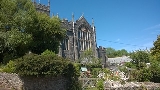
After lunch I took a little time out to stroll to what appears to be the main shopping street, West Street. I then took a little closer look at St Eustachius' Parish Church. Like many things in Tavistock, this 'parish' church is impressive beyond expectations for a place such as Tavistock, indicative I felt of the past status, industry and wealth of Tavistock in its heyday. The panorama below shows the altar of St Eustachius’ Parish Church.

Tavistock - Church of St Eustachius (
Grade II Listed) - English Heritage List

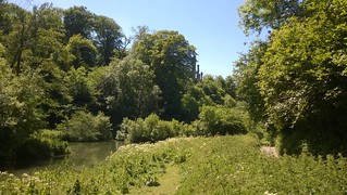
Tavistock - the trail runs along the banks of the River Tavy
Without being able to do Tavistock justice, I needed to be on my way as I had plenty of cycling still ahead of me (13:51 pm). I backtracked slightly, crossing the main bridge over the River Tavy, and then following a path along the banks of that river. My way then snaked through some less than noteworthy Tavistock environs of suburbs and supermarkets before I regained the course of the dismantled railway.

Grenofen Tunnel
I was soon approaching Grenofen Tunnel, for which I'd come prepared, or at least I thought I had. I had brought lights with me, as I knew it would be dark. A cyclist that approached, travelling in the opposite direction to me, I didn't spot till the last minute, highlighting the need for concentration through the tunnel. But what I wasn't prepared for was how wet the tunnel would be. It was dripping a substantial amount of cold water, which I hadn't expected. It was quite refreshing, without my needing to resort to my waterproof jacket.

Gem Bridge, over the River Walkham
Just a little way on from Grenofen Tunnel I came to Gem Bridge, the spur for this cycling day of mine. This is a stylish modern bridge, built for the sole use of walkers and cyclists. I think it's wonderful. I stopped to look down on the River Walkham 24 metres below me. It's an inspiration. It certainly inspired me to be out here today.
From here (3.7 miles from Tavistock/14:37 pm) starts what is probably the biggest climb of the day (92 to 195 metres). This climb took me up onto the downs of Yelverton. Here can be seen the scant remain of what, during WWII, was RAF Horrabridge (apparently the name Yelverton couldn't be used as it might have possibly been confused with Yeovilton). Through trees I glimpsed Yelverton parish church. There are facilities adjacent to the church.

Clearbrook - I think this is Drake's Leat or Plymouth leat, now disused
My way was distinctly marked, through trees, in the direction of Clearbrook. I could clearly see a substantial leat, which I take to be Drake's Leat, that provided a water supply from Burrator to the citizens of Plymouth.

Clearbrook - there had to be Dartmoor ponies - photo taken not far from the Skylark Inn, a favourite eating place of mine
The Skylark Inn at Clearbrook (8.7 miles from Tavistock/15:30 pm) is a popular eating place, one I've used on a number of occasions, and one I can recommend. However time today would not allow such delights, so I made do with a quick photograph of some Dartmoor ponies meandering the lanes through the villlage.

Devon's gently rolling lush green hills
A good part of the next stage of my cycle route I had cycled before, some years ago, coming up from the popular car park at Plymbridge Woods. From here it is relatively plain sailing, descending the gentle incline of the course of the dismantled railway. There was one more tunnel to negotiate, through which bicycle lights are once again recommended.
The cycle route is well signposted under the busy A38. The Saltram House (NT) estate I skirted close to the left of me, and then followed a nicely redeveloped trail that looks out on the River Plym.

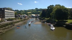
Plymouth - Laira Bridge, now a pedestrian/cycle way - what an excellent transformation
I was pleasantly surprised to find that the old steel Laira Bridge has been newly kitted out as a cycle route over the River Plym. Some further improvements are ongoing, but this is a great asset for cyclists, providing an important connection between the city centre and the river and Saltram.

Plymouth - view over the River Plym from Cattedown Road
One final push was required of me at Cattedown, to climb the road that circles the old Victoria Fort. It was worth the effort for the views out across the mouth of the River Plym to Mount Batten.

Plymouth - The Barbican
I was pleased to see my goal come into sight, Plymouth Barbican (19.5 miles from Tavistock/16:42 pm). The sun was shining and the place looked beautiful. I took a little time out to wander around the barbican.
Glancing at the train times I became aware that a train was due to depart at 17:25. I knew it would be a dash, and with little energy left in me, I decided I really like to be on my way. So (16:53 pm), with a great effort, I cycled up over The Hoe, down the seafront, and then back across town to Plymouth railway station (3.1 miles from Plymouth Barbican/17:15 pm). And yes, my train, which was punctual, I did catch. After a quick connection (6 minutes) at Newton Abbot, I arrived back at my local station (Digby & Sowton) in Exeter bang on schedule at 18:58. That was good going.
It had been a tremendous day's cycling, and one that I can wholeheartedly recommend to anyone looking for a day out on a bicycle in Devon. All involved in making such a day possible, including the infrastructure investment and organising all the required train services, are to be highly commended for what has been achieved. It only surprises me that such a magnificent facility isn't better publicised. I asked about the cycle trails at the Tourist Information Centre in Exeter, and discovered the staff knew nothing about it.
Cycle Statistics:
Trail Distance (Granite Way & Drake’s Trail): 39.7 miles
Total Distance (Granite Way & Drake’s Trail + cycling to/from railway stations): 46.8 miles
….. To St Jame’s Park halt from home: 2 miles
….. To Plymouth railway station from Barbican: 3.1 miles
….. To home from Digby & Sowton: 2 miles
Moving Time: 4hrs 46min
Stopped Time: 1hr 29min
Total Ascent: 627 metres
Maximum Elevation: 296 metres
Buses: (none)
Trains: Outward: St Jame’s Park to Okehampton; Inward: Plymouth to Digby & Sowton
Train ticket: Devon Day Ranger £10.00