Synopsis: A walk from Chudleigh Knighton to Bovey Tracey. Includes Chudleigh Knighton Heath and Little Bradley Ponds. Also a glimpse of Blue Waters Pond, previously a coal (lignite) mine.
Statistics and tracklog overlay on Open Street Map (OSM) and Open Cycle Map (OCM) Runtastic


 (selection of photos from Flickr photo set – use link above to view album)
Spontaneous walking. I think that best describes today’s walk. I normally map out my route in fine detail and load it to my GPS, as this makes walk navigation on the day very easy. But today, I simply glanced over Ordnance Survey mapping, and checked bus times out of Exeter, and set about my walk. In part, I wanted to allow myself the freedom to explore just exactly where I could and could not walk, which wasn’t entirely evident from maps. I had in mind two features that I’d like to include in the walk, Devon House and Blue Waters Pond, both of which I explain below.
Recently I’d visited the heath lands in this area on a walk with some ex-colleagues of mine. We didn’t have time on that walk to explore all that I hoped (too much talking and not enough walking I’m afraid). So, at least in part, motivation for today’s walk arose from that previous visit.

[Chudleigh Knighton]: The Claycutter's Arms (was there only one claycutter?)
The bus from Exeter that I travelled on dropped me as planned at the Anchor Inn bus stop in Chudleigh Knighton. The first observation that I made today was, there’s no Anchor Inn here. It had been demolished. I could recollect vaguely what it had looked like, and I remembered noting that it looked a little run down. Well, it is now entirely run down, just a pile of rubble. Apparently pubs are closing at a great rate right across the country. I passed this, the Claycutter’s Arms, in Chudleigh Knighton, with seemingly a better fate.

[Chudleigh Knighton Heath]: Information board showing Ant Trail
I followed the road out of sleepy Chudleigh Knighton. On the outskirts of the village, there was an information board for Chudleigh Knighton Heath which showed me where I was and the direction in which I needed to walk. Apparently, I would be walking on the Ant Trail. There are some rather peculiar ants on the heathlands in this area, so I’m led to believe. There are way-post markers that dot the trail, so route finding was easy.

[Chudleigh Knighton Heath]: Connecting path to the left of my walk along the Ant Trail
I reached a point where there seemed to be a connecting path to my left that I thought might exist. This path I assumed to connect with the previous walk I’d done with my ex-colleagues a few weeks ago. I decide to explore the path to see if I was correct in that supposition, with the intention of walking out and then returning to this point.

[Chudleigh Knighton Heath]: Quiet and peaceful, and the place to myself
And yes, just as I expected, the path I followed led me to a point that connected with my previous walk. It was lovely and peaceful out on the heathland, with not a soul about. The trees all about in the bright colours of their new foliage. It’s a great time to be in the country.
Returning to the point of my path of primary intent, I continued along this, heading roughly in the direction of Little Bradley Ponds. This is a nature reserve managed by Devon Wildlife Trust. I was approaching from a new direction requiring me to explore navigation options as I went. Part of the way could be walked along a path on the edge of woods, but after a while it was necessary for me to return to the road and walk, with extreme caution, down hill to where the entrance to Little Bradley Ponds was to be found.
Choosing the left lake to explore first, I set off on the perimeter path that encircles the lake. One of these lakes is apparently an old ball clay works. I think it is not this first lake, but the lake across the road from it. The path around that other lake looks white and appears like clay.
[
Little Bradley Ponds - [Devon Wildlife Trust]]: Possible point of entry to the ponds, but involves scrambling over a low wall
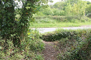
Part way around the lake I was encircling I noted a path off to my left. I decided to explore where this led. There are no clues on maps as to where this path might lead. Climbing along this path for a while I eventually discovered that it led out to the road along which I had just walked. There is no ‘official’ entry onto this path, and in fact there is a wall at the point where the path connects with the road, but is clearly used by some people as an entry to the lake. If I’d known it was there, and was prepared to climb the wall (about 0.8 metre high) I could have avoided the need to have walked some of the road I’d just traversed.
Regaining the path around the lake, I was now at the highest point along this path. The path is narrow and winds it’s way through small trees and scrub, but is easy to progress along. I was soon descending once again, and it wasn’t long before the lake, or should I say pond, came into sight once again.
Completing the circuit of this first lake, I was back at the road where I could enter the opposite lake. This lake, slightly larger than the first I’d walked, has a perimeter path like the first. Part way into this walk I once again noticed a path off to my left, and once again, decided I’d like to explore. I had noted from having previously perused a map of this area, that there was another lake nearby. I came upon a stream to be negotiated via a collapsed bridge, but once across this, another lake came into view.

A pond that is close to Little Bradley Ponds.
I’d previously visited the first two lakes I mention here, but this lake I’d not seen before. It was clearly a lake for fishermen, as all around it can be found numbered fishing stations. I followed the path in a south-easterly direction eventually reaching a path intersection point with a path leading off left across fields. At this point I realised that I was on a public footpath I’d seen earlier on the map. There is a sign on the lake perimeter path that says fishing permit holders only are permitted to proceed further along this path. I was happy to return the way I came, as I now wished to follow this public footpath in the direction of Bovey Tracey.
Entering Bovey Tracey I picked up Combe Lane, which in turn led me to a road named Devon House Drive. This left me in little doubt I was headed in the right direction. The ‘drive’ is now lined with bungalows. As I walked along this road Devon House and its grounds came into sight. I could immediately see how similar this building was to other such Victorian institutions of this period, with a sturdy looking building located in grounds planted with various cedars. Quite peaceful and elegant in its own way.
The building was previously known as Devon House of Mercy. It was run by nuns, and was meant to be a sanctuary for ‘penitent’ or ‘fallen women’. A laundry service was operated from the institution. In many ways, I presume this to be not unlike the infamous Magdalene Sisters, the story of which was made into a film about ten years ago. I’d recently re-watched the film, which reminded me of the horrors practised at such inhumane institutions. I suppose that piqued my interest in visiting this place.
Devon House is now flats. One of the residents was decidedly unfriendly and asked me what I was doing. I explained I was simply walking through and taking a few photos as I went. Effectively, he told me to bugger off, despite my protestations, saying I was doing no harm. One of the last relics of the Miserable English so wonderfully portrayed by John Cleese all those years ago. Shame they don’t recognise themselves.
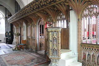
Picking up the public footpath that leads off from Devon House back in the direction of Bovey Tracey, I descended the hillside, and re-joined the road near to the parish church of St Peter and St Paul and St Thomas of Canterbury (Listed Grade I). I took a little time out from my walk to visit the church, as I usually do. It has an absolutely amazing rood screen. The pulpit is very impressive too.
Outside the church I found myself looking for golden frogs. There is a small water trough set in the wall below the church, which today is dry. There is an ancient legend of golden frogs that surrounds this water trough, a delightful legend, which can be read about on the Legendary Dartmoor web site.

[Bovey Tracey]: My picnic lunch spot, a bench by the River Bovey
I continued my walk, entering the main street of Bovey Tracey, busy today, in part because there was a local market taking place. It was just a little after midday and I was getting to be a tad hungry, not least because I’d had an early breakfast. I knew there was a park by the River Bovey at the lower end of town, not far from the old mill, that I thought I’d seek out. And, just as I had hoped, there on the banks of the river was the perfect park bench, an ideal stop for my lunch break. I sat and watched the grey flycatchers catching their lunch as I ate mine.
After I’d eaten my lunch I backtracked to the road bridge over the River Bovey. From here, a public footpath led me away from the car park and up the hill. A little way further and I came across The Church of St John the Evangelist (Listed Grade II*). Initially, although noting the pleasing aesthetics of the church, it had been my intention to merely walk by, when I noticed a substantial monument in the church cemetery. It immediately occurred to me that this was the monument that I’d been mistakenly looking for in the church of St Peter and St Paul and St Thomas of Canterbury, visited earlier.
Previous to my walk today I’d read the story of the deaths of 3 sisters (echoes of Macbeth here), Emily Gurney, b.1843, Lutterworth, Leicestershire, Rosamund Gurney, b. 1851, London and Mary Gurney, b. 1855, London (Ancestry Message Boards). They were daughters of Rev. John Hampden Gurney, Prebendery of St Paul's Cathedral. The sisters all drowned in the River Nile in 1875. Apparently a storm blew up and the boat they were on capsized. If you wish to read more of this story I recommend you visit the blog post ‘Russell Gurney (1804-1878) and the Melancholy Accident’ by Colin Salter. This includes an extract from the New York Sunday Courier for 30th January 1876 which recounts the story of this tragic accident.
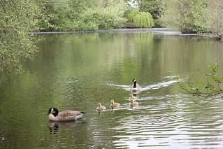
[Bovey Tracey]: Pottery Pond and Canada Geese
Moving on, I Picked up a public footpath that followed the banks of Pottery Pond. This, as its name implies, was a pond created to power the once thriving pottery industry of Bovey Tracey. This pond alone powered five water wheels. Today it is the tranquil preserve of ducks and geese. A family of Canada Geese with fluffy goslings waddled by as I too waddled on my way.

[Bovey Tracey]: Blue Waters Pond - previously this was a lignite coal mine
The bigger pond that I was seeking out was that named Blue Waters Pond. I was curious to see this as it was once a working coal mine. At one time lignite, a low grade coal, was mined here, well into the middle of the 20th century. I suspected that I would only be able to glimpse the pond as I was fairly certain that unfortunately there is no public access to its shores. This was driven home to me by an ‘Only site residents allowed by this lake’ sign posted on the boundary to the lake. Still, I did at least manage to catch this view of the Blue Waters Pond.

Templer Way running through the tranquil Great Plantation
At this point in my walk was on the Templer Way designated walk route. It was necessary for me to walk some length (about 1.4 kms) of this walk route along a road, which required some care. Eventually, near Belle-vue, the route left the road and entered woodland. This was a quiet tranquil place, a delight to walk through.
I was headed for Drumbridges Roundabout, as there are bus stops on this roundabout from where I would be able to catch a bus home. Unfortunately my timing wasn’t brilliant, as I’d have to wait nearly an hour for a bus. There was however a comfortable shelter in which I could sit and await my bus.
It had been not a very long walk, nor was it that demanding, but it had been a walk that had much variety in it. I’d achieved my various objectives for the outing, and had had a relaxing and enjoyable day’s walking. The countryside was looking crisp and fresh in its spring habit.
Walk Statistics:
Total Distance: 14.49 km / 9.0 miles
Moving Time: 3hrs 47min
Stopped Time: 46min
Total Ascent: 178 metres
Maximum Elevation: 75 metres
Buses: 39 & H