Saturday 25 July 2015

25 July 2015 - Walk: Dartmouth Castle (EH), Warfleet and Dartmouth (5.1 Miles)

Synopsis: Bus trip to Dartmouth to visit Dartmouth Castle using my newly acquired English Heritage membership. Explored some of the coves just south of the castle. Kingswear Castle sailed by.

GPS Tracklog Download (.gpx) Microsoft OneDrive -:- Google Drive


RJS-LUMIA-2520 - IMG_2206RJS-LUMIA-2520 - IMG_2208RJS-LUMIA-2520 - IMG_2217RJS-LUMIA-2520 - IMG_2219RJS-LUMIA-2520 - IMG_2225IMG_2258
(selection of photos from Flickr photo set – use link above to view album)

I wasn’t quite sure where this day would take me. I decided I’d like to visit a castle, but which I had not decided upon. I’d just become a member of English Heritage, so it was time for me to pick up the heritage trail. I wrote this blog post on the go, therefore its style reflects this and is a little different to my normal style.

[08:53]: The bus for Dartmouth picked me up punctually from the crematorium. Doesn't sound good does it? But that is the bus stop I frequently use, as it's only a short and pleasant stroll across Ludwell Valley Park from my home. I recently discovered that the name Ludwell originally derived from 'Loud Well'. That would seem to make sense.

RJS-LUMIA-2520 - IMG_2203
[Dartmouth]: Quay

[10:47]: Arrived Dartmouth. You've probably surmised my 'castles in the sky' (the name I gave my Flickr album) has now dropped to earth, in that I've chosen to visit Dartmouth Castle (EH). The primary trigger for this visit is the fact that I joined English Heritage earlier in the week, so this is the start of my 'money's worth' campaign. Another trigger being that a few weeks back I was on the opposite shore, Kingswear, looking across at Dartmouth Castle, thinking I'd like to pay it a visit once again. And guess what? Here I am. Other Devon castle options for today would have been Berry Pomeroy, Totnes or Okehampton.

RJS-LUMIA-2520 - IMG_2204
[Dartmouth]: Japanese Garden

[10:55]: That's a rather unexpected find, a Japanese garden in Dartmouth. That wasn't there on my last visit. It looks attractive, and is certainly a very novel idea. But I do have my doubts about just how authentically Japanese it really is. I'm of the impression that the most Japanese aspect of the garden was the artificial bridge.

RJS-LUMIA-2520 - IMG_2229
[Dartmouth]: Dartmouth Castle


[12:15]: Reached Dartmouth Castle, showed the man in the ticket office my English Heritage membership email, and he let me in. The gentleman knew his history, and told me a lot about the castle, and the chain used to bar enemy ships entry. He pointed out Gommerock on the opposite shore, where the chain was anchored to hooks embedded in the rock. Apparently four of these holes are visible today. The tower which once stood there is now gone, but there appears to be a little of the tower's base still in place.


RJS-LUMIA-2520 - IMG_2232
[Dartmouth]: Dartmouth Castle, viewed from the picnic area just above the car park


[13:15]: Enjoyed my very interesting visit of the castle, and now perched high above the castle looking out over the mouth of the river and eating my picnic lunch. Fishing boats are returning, presumably with their catches. Tomorrow's fish and chips, if the sign outside the fish and chip shop is to be believed.

Kingswear Castle, in the distance almost masked by the tower, is a Landmark Trust property, and therefore available to rent.

IMG_2236
Sugary Green. That's the name of this park. Isn't that delicious?


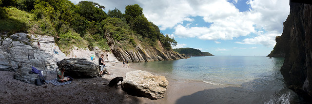
[14:15]: I decided to explore a couple of the nearby coves upon finishing my lunch. As I made my way around the ruined walls of the oldest part of Dartmouth Castle, and then up a path into trees, I came across, rather unexpectedly, a park, with the lovely name of Sugary Green. Now, isn't that a delicious name, if ever there was one?

IMG_2244
[Sugary Cove]: A secluded cove near Dartmouth Castle


[14:30]: From Sugary Green it was only a short walk to the nearby coves I was seeking to find. These are secluded coves that can only be glimpsed from the coastal path, which here runs up and down like a rollercoaster. I first became aware of these coves when I spotted old photos of them on the Francis Frith web site (see: 'Dartmouth, Bathing Cove Forward Point 1894'). My photo contains more links to old photos.


[14:36]: It can be seen from the old photos of these coves, that at one time they were very popular. There appear to have been amenities such as cafés built on stilts on the cliff side at one time. Although these amenities are long gone, some people still choose to seek out these secluded coves, and it's easy to see why …

Dartmouth 046_stitch
[Sugary Cove]: This cove is just a little south of Dartmouth Castle

[15:40]: Back in the centre of Dartmouth now, sat on a bench at the entrance to Royal Avenue Gardens. There's a lovely fountain here, which, whenever I see it I think of my Uncle Len and Aunt Gwen, as we have pictures of them stood in front of this fountain in our collection of old photos (see below). I'm fairly convinced they will have ridden down on one of Len's motorcycles, considering the way they are dressed. It's rather difficult to date the photos, but I should imagine they were taken in the 1950s. I've also included some photos of the motorbike they were likely to have been riding, although I have no knowledge of what make and model this would be.

Photo Album 01-007c
Leonard Henry Rockett, in Dartmouth, in the Royal Avenue Gardens, by the fountain
Photo Album 01-007a
Gwendoline May Rockett, in Dartmouth, in the Royal Avenue Gardens, by the fountain
Photo Album 01-006d
[RJS]: Leonard Henry Rockett with one of a succession of his motorbikes
Photo Album 01-006e
[RJS]: Leonard Henry Rockett with one of a succession of his motorbikes

[16:10] I'm hoping to catch the 16:55 bus from Dartmouth, so I've a little time to spare. I'm loading a few photos to this 'post in preparation', after which I'll take a brief stroll around the gardens once again.

Dartmouth 063
[Dartmouth]: Kingswear Castle paddle steamer

[16:44]: Oh my goodness! My bus will depart in 10 minutes time, and I've just seen the Kingswear Castle sail by. It's no good, I just had to risk it. I shot along Dartmouth Quay and was just in time to shoot a small amount of video footage which shows the Kingswear Castle pulling away from her jetty. I'm so pleased I did. She's a lovely boat, and looks, and sounds, just gorgeous. The description of my video contains links to old photos of Kingswear Castle.


[16:55] Right on time, I'm on the bus and headed home. Although, ostensibly, my trip today was to visit Dartmouth Castle, who really needs an excuse to visit Dartmouth? It has to be one of the most attractive and interesting places in Devon. Walk? Well, ok, not a great distance at all, although the height gain (see walk statistics below) was surprisingly more than I had expected. But no, not so much a walk as a stroll. A very pleasant trip all the same.

Walk Statistics:

Total Distance: 8.2 km / 5.1 miles
Moving Time: 1hrs 57min
Stopped Time: 1hrs 52min
Total Ascent: 462 metres
Maximum Elevation: 42 metres

Buses: X64 and H

Wednesday 22 July 2015

22 July 2015 - Cycle: Woodbury Common, Budleigh Salterton and Exmouth (33.7 Miles)

Synopsis: A favourite route of mine, involving some off-road cycling over Woodbury Common. A nice mix of country lanes and a seaside or two also mixed in. A tough day physically, but very rewarding.

GPS Tracklog Download (.gpx) Microsoft OneDrive -:- Google Drive


Woodbury Common 017RJS-LUMIA-2520 - WIN_20150722_135548RJS-LUMIA-2520 - WP_20150722_15_32_09_ProRJS-LUMIA-2520 - WP_20150722_15_49_19_PanoramaRJS-LUMIA-2520 - WP_20150722_16_05_10_ProRJS-LUMIA-2520 - WP_20150722_17_24_49_Pro
(selection of photos from Flickr photo set – use link above to view album)

This is a repeat of a cycle route Helen & Can, Laura & Uwe, and me, cycled on Tuesday 9th September 2014. It's quite a long cycle, for me at least, but it's a great ride. I wrote these blog notes in a OneNote notebook whilst on the trail initially, just as an exercise in blogging on the go at this stage, my first attempt at this. It worked really well, as OneNote automatically synchronises edits on the fly. I’ve since copied my writings here, to my blog. The technique of writing on the trail explains the slight variation in style of this post, from the style I typically use.

[12:19]: Set off from home. Running somewhat later than I might have hoped. Why does it always have to be like that? Anyway, the odd rain shower should have passed overhead by now, so hopefully this will be a dry cycle ride. It was certainly warming up nicely by the time I left home.

[13:25]: Reached my first port of call, Farringdon. Had a picnic lunch in the grounds of the charming parish church. Not my first visit, but always a delight to return to this place. The interior walls of the church are covered with lots of little motifs, which I understand, were painted by a wife of one of the incumbents. I think they're quite lovely. This is a church that you either love or hate. I think you can probably guess which camp I'm in. Apparently the Exeter born historian William George Hoskins opinion of this church, was to describe it as “hideous”.

RJS-LUMIA-2520 - WP_20150722_15_14_32_Pro
Woodbury Common - looking towards the coast, the sea can be glimpsed in the far distance


[15:14]: And I'm still on Woodbury Common. A lot of cycling remains ahead of me, and yet yet again I stop to take a photograph. But, looking at this view, who can blame me? Isn't it gorgeous? I sometimes think Woodbury Common is rather overlooked, with the two local moors, Dartmoor and Exmoor, taking precedence. But Woodbury Common is a rewarding place to visit, and it's right on my doorstep.


RJS-LUMIA-2520 - WP_20150722_16_32_30_Pro
Budleigh Salterton - the beach, looking east

[16:28]: Now I'm in Budleigh Salterton, which is looking beautiful in the sun. That's perhaps the hardest part of my journey behind me, the climb over Woodbury Common. It's fairly tough for two reasons, 1: there's the climb to be got over, & 2: there are some rough off-road tracks to be negotiated. In truth, the off-road sections are a lot of fun to a 'kid' like me. In particular, I always like the challenge of crossing the ford, hopefully without getting my feet wet.


I feel I've done my good deed for the day too. I came around this bend in the lane, and there in the middle of the lane was a bird of prey, with a baby rabbit pinned down in its claws. I of course startled the bird, but at first it was reluctant to give up its meal. It attempted to take flight, twice, with the live rabbit in its claws, but the rabbit was too heavy, and was wriggling frantically to free itself. Eventually the buzzard, which is what I think it was, gave up, and took flight. The little bunny probably escaped with nothing more than a scratch or two, and something of a scare, but otherwise looked in good health as it darted for cover in the hedge.

RJS-LUMIA-2520 - WIN_20150722_170430
Budleigh Salterton - A family, whose beach hut is on the left, are setting up a picnic on the beach

It's quite warm, and I'm glad of the shade this little seafront shelter has to offer. I'm probably looking rather hot and bothered after my cycle ride here. Luckily, there's no one to notice but the occasional passer-by, and they seem more interested in their ice creams, and who can blame them for that. A family has just set their picnic table up on the pebble beach just in front of where I'm sitting. I wonder if I shall be invited to join them for a cup of tea. I should be so lucky. The family have a beach hut, which all seems so very civilised, if not to say English. They even have a tablecloth, although plastic coated, for their table.

RJS-LUMIA-2520 - WP_20150722_17_30_43_Pro
Budleigh Salterton - the beach, looking east, with seaside rock artist

I shall take a brief stroll along the seafront in a little while, neatly side-stepping the temptations of the ice cream shop. But I mustn't linger too long, as I must set out on the next stage of my journey, the ride along the dismantled railway from Budleigh Salterton to Exmouth. There's just no peace for the wicked, is there?


RJS-LUMIA-2520 - WIN_20150722_185024
Exmouth - my view from the shelter in which I sat to eat my fish & chips - little to complain about, except the bloody seagulls on the prowl


[18:48]: It seems I have made it to Exmouth, at last. Right, silence from me now, as I eat my fish & chips.

[19:22]: I must say, the fish & chips were very nice. At £6.00, I would expect them to be. Is that the going rate these days? I must get out more. I remember when fish & chips were 2s 10d. Now you're wondering, just how old can this guy be?


But enough moaning. What a glorious evening to be down here in Exmouth. I feel like I'm on holiday. I suppose, some would say I am. I have to confess to being a lucky bugger, if you'll excuse my French, as a certain aunt of mine would say. One last glance over my shoulder as I’m about to set off from Exmouth, a view of the new Premier Inn, situated on the seafront at Exmouth, next to The Bath House. It replaces the Elizabeth Hall that previously stood on this site. The new building is styled with certain Art Deco references, and is a bit squashed into a small site, but reasonably smart looking.

[Exmouth]: The new Premier Inn
[Exmouth]: The new Premier Inn

[19:28]: And I've yet to reach home, so I must get cycling. A following wind would be nice - is that too much to ask? Yes, I thought so too. Ok, sweat and tears it will have to be, but I'll try to avoid the blood.

RJS-LUMIA-2520 - WIN_20150722_202953
Topsham - The Goat Walk, Topsham. I took a short break sat on a bench overlooking the sun setting on the River Exe.

[20:31]: Arrived Topsham, still in sunlight. I'm not sure what's fading quickest, me or the daylight. Evenings are really the loveliest time of day. It seems a shame that's the time so many people are watching television. Isn't it interesting, though, to read that TV licence ownership has dropped to the same level it was at in 1972. Perhaps we've lived through the TV age. I suppose the question is, what will be the next distraction? That’s probably not hard to fathom. I recently read, “People walk about in a state of distractibility.” I think cycling could be the antidote.


[21:25]: Home, at last. Rather later than I'd intended. But, then, I did start out rather late, and it was never my intention to rush. Surprisingly, I wasn't too exhausted come the end of my ride. That must be down to the new fitter me. Doubt me? See my fitness profile on Runtastic (link above/right) if you are in need of proof.

Well, the 'blog' writing on-the-go, as shown above, I feel went really well today. By using OneNote, I was able to simply write my notes in this 'Blog Share' notebook, a bit at a time as I went about my day, and could allow the auto-synchronisation capability of OneNote to post my updates back to the cloud. I simply put a link to this shared notebook in the description of my Flickr photo album that I created for this trip. Technology just gets better and better.

Description and photos of a previous visit of mine to Farringdon can be found from the following links:

Cycle Statistics:

Total Distance: 54.2 km / 33.7 miles
Moving Time: 4hrs 50min
Stopped Time: 2hrs 36min
Total Ascent: 704 metres
Maximum Elevation: 162 metres

Buses: (none)

Saturday 11 July 2015

11 July 2015 - Walk: Tavistock to Bere Alston, bus out, train return (9.5 Miles)

Synopsis: A walk along the perimeter of Dartmoor. Tavistock is a lovely place, that I’m only now beginning to discover. Double Waters, the confluence of the River Walkham and the River Tavy, is idyllic.

GPS Tracklog Download (.gpx) Microsoft OneDrive -:- Google Drive


Tavistock to Bere Alston 002Tavistock to Bere Alston 007Tavistock to Bere Alston 035Tavistock to Bere Alston 039Tavistock to Bere Alston 068Tavistock to Bere Alston 102
(selection of photos from Flickr photo set – use link above to view album)

I was looking at the bus map for Devon on the previous day to this walk, just scanning it for interesting destinations. In doing so, I noticed the 82 bus served Tavistock, a place I’d cycled through a few weeks previously, and thought an interesting place I’d like to explore more. In thinking about how to make a walk out of this, I realised the rail route between Plymouth and Gunnislake wasn’t far away. I toyed with the idea of taking in one of the National Trust properties (Buckland Abbey and Cotehele) nearby, but this would have been difficult, so in the end settled on this walk from Tavistock to Bere Alston.

Bus services to Tavistock are few and far between. There was only one bus I could catch for this walk, the 82 leaving Exeter at 10:25. It’s a mighty journey for a bus, lasting just over two hours, but I was happy to sit back and enjoy the scenery of the journey. There were only five passengers on this bus. The view seems to be that this service is doomed to be deleted, so it was just as well I was making this trip today.

Tavistock to Bere Alston 001
[Tavistock]: bus station

On alighting from the bus in Tavistock (12:35 arrival), I immediately caught sight of a small kiosk selling pasties. Just the ticket, as that way I could keep my sandwiches for supper later in the day. I cut down Canal Street where I saw an information notice board with information about the Tavistock Canal. Not surprisingly, the canal is to be seen running under Canal Street. Despite having been nearby on several occasions, this was the first time I’d taken note of the canal. It isn’t large, being, I imagine, just the width of a canal barge.

Tavistock to Bere Alston 011
[Tavistock]: River Tavy - Abbey Bridge


I followed a path along the banks of the River Tavy, eating my pasty as I went, up to Abbey Bridge, where I crossed the river. It’s very picturesque and serene by the river, and I noticed a number of benches set under trees, which would have made, had I the time, a cool place to rest and relax. Instead, I continued on my way, crossing over the river once again, this time on a footbridge, which led me into Meadow Lands park.

Tavistock to Bere Alston 014
[Tavistock]: Meadow Lands park - Tavistock Canal


I could see what looked to me like the bank of the canal, so I made a slight detour to take a closer look. That was indeed what it was. Nice to see that the old canal, at least in part, still exists today, long after its working life had expired. This is the Tavistock Canal, which provided a valuable service for the industry of Tavistock and its environs for more than forty years. Now, it is just a haven for ducks, and of course the children who feed them.

Tavistock to Bere Alston 016
[Tavistock]: The Bedford Cottages Workers cottages built by the Dukes of Bedford between 1845 and 1865.


At the furthest reach of the park, I walked out onto the busy Plymouth Road whereupon I came across quite a number of old cottages. I should imagine they’re either old workers cottages, or alms houses. They’re very picturesque, and, once again, it’s lovely that they survive to this day. In fact one was for sale. I was sorely tempted to enquire. There is talk of the old rail link with Plymouth being re-instigated, which would make Tavistock a very attractive commuter place to live (‘David Cameron says Okehampton railway line is 'most resilient'’ – BBC News 30/01/2015).

Tavistock to Bere Alston 020
Lane heading south out of Tavistock


On my way out of Tavistock, I passed near to Morrison’s, so I popped in for a couple of yoghurts for later. Then, it was a matter of following a lane, which forms part of West Devon Way, described as a ‘waymarked walking route’, but I have to confess, I didn’t see any waymarks as I walked part of this route today. I passed the grand old Walreddon Manor (Listed Grade I) (snapped) on my way along the lane.

Tavistock to Bere Alston 022
West Down - car parking is limited

Since my way out of Tavistock was along this lane, the latter part of which is clearly marked as a dead-end, I was surprised by the amount of traffic on the road. All became clear when I reached the end of the lane, at the point at which a gate leads onto West Down, where, parked on the sides of the lane, were numerous cars, the owners obviously taking a stroll on West Down. Considering how popular a location this evidently is, I was a little surprised no proper parking arrangements were in place at this spot. But, anyway, many people were obviously making the best of things.

Tavistock to Bere Alston 025
West Down - Dartmoor ponies


Just a little way onto West Down the view suddenly opened up to me. I was looking across a fern covered hilltop into a valley lined with trees. It seemed the perfect place to break for a snack and a drink, and, luckily, there were some granite boulders conveniently positioned for me to select one on which to perch. I had plenty of company, as ponies were grazing nearby, and would wander by me.

Tavistock to Bere Alston 048
Confluence of the River Tavy and the River Walkham


After lunch I continued along a very distinct track that led me down the hillside towards a point named Double Waters, the confluence of the River Tavy and the River Walkham. I’d known of this place from a visit of mine many, many years ago, and came tantalizingly close to it on a recent walk. It is an extremely beautiful spot, and it alone was sufficient to make my walk today worthwhile. I lingered a while, taking photographs as I soaked up the tranquil beauty of the spot.

I crossed over the River Walkham by way of a footbridge and continued on along the banks of the River Tavy. This led me to another lovely spot, a sharp bend in the river at a steep cliff, where, to my surprise, there was a bench complete with a ramshackle shelter. I spotted a kingfisher dart by me, its electric blue colour glinting in the dappled sunlight. I hardly need say, I failed to capture a photo of it. I did however capture this panoramic view of this pebble beach.

Tavistock to Bere Alston 061_stitch
A beautiful secluded pebble beach on the River Tavy, complete with ramshackle bench and canopy. Heaven!
Tavistock to Bere Alston 076
Approaching Berra Tor, looking back towards West Down

The track passed Tavy Cottage and began to ascend the hillside through trees before opening out onto open moorland. The high ferns somewhat obscured my way forward, but I managed to pick my way down a somewhat overgrown path just below Berra Tor.

Tavistock to Bere Alston 080
Hatch Mill


A short stretch down a dirt track soon connected me with a lane down which I continued along on my descent to once again rejoin the River Tavy near Hatch Mill. The weir that once fed the mill leat, now dry, is still shown on the map, and a path on the opposite bank leads down to it. There was some old rusting ancient farm machinery just outside the mill, standing next to a disused millstone.

Tavistock to Bere Alston 087
River Tavy - a short distance downstream from Hatch Mill


This is a lovely spot, as the path hugs quite closely the course of the River Tavy at this point. On a summer’s day like today, with the sun glinting off the water, this was the perfect place to be. I passed another, somewhat ruined, weir, with waterwheel chute, but no buildings remained at the site.

Tavistock to Bere Alston 096-HDRx54x54x34x30x16x18
Denham Bridge over the River Tavy


Following a lane for a short distance, I was soon at Denham Bridge. I’d been here before, but approached along the opposite lane, from Buckland Abbey, on a recent walk. Like then, I knew I would now have to climb the quite steep hill up the lane from here. The lane is a little busier than one might expect, but walked with care, this is not a problem.

A little further along the lane I branched off right onto a footpath across fields. I then picked up a lane, passing by Mount Tamar house, and over a bridge over the dismantled railway that once connected the railway at Bere Alston to Tavistock.


Tavistock to Bere Alston 105
A superb view of the Calstock viaduct on my approach to Bere Alston

Much of the losses arising from the Beeching Cuts are to be lamented, but I feel the loss of this connection with Tavistock is such a shame. The fact that it would connect Tavistock with Plymouth, and that much of the track-bed still exists, must surely be worth a rethink. But then, what do I know? (Further reading: Bid to reopen old train line – BBC News Friday 19th September 2008.) This is a superb view of Calstock Viaduct, I do know that much.


Tavistock to Bere Alston 107
Bere Alston railway station


My way then took me along a track under a bridge that once carried this now lost railway. I was by now only a short distance from the end of my walk, the railway station at Bere Alston. How lovely it always is, I feel, to come across a railway station in the country with a service still operating. The railway buildings look, if not quite pristine, in remarkably good order considering the more than one hundred years service that they have given. The Victorians sure knew how to build to last.


It had been a reasonably demanding walk, with three quite steep hills to be climbed, giving a rather high Total Ascent (see Walk Statistics below), and the day had been rather warm and humid. I arrived about 40 minutes early for my train to Plymouth (17:49 departure), and in fact saw it come and go, as it had to run to Gunnislake prior to returning to Bere Alston. I was glad of the time to rest, relax and eat my picnic supper on the platform, which I had to myself for the majority of the time.

Walk Statistics:

Total Distance: 12.59 km / 9.5 miles
Moving Time: 3hrs 19min
Stopped Time: 45min
Total Ascent: 411 metres
Maximum Elevation: 164 metres

Buses: 82 Exeter to Tavistock £6.30
Trains: Bere Alston to Digby & Sowton off-peak single £9.90