Synopsis: A chance to see the Salem Chapel, East Budleigh on Heritage Open Days. Cycle route over Woodbury Common involves small amount of off-road riding. Popped in on Farringdon Church for lunch.


(selection of photos from Flickr photo set – use link above to view album)
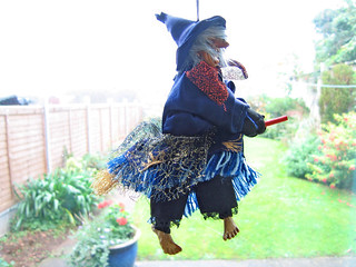
‘Double, double toil and trouble; Fire burn, and caldron bubble.’ And other such conjuring by the Weird Sisters. But let’s leave that aside for the moment. This blog post describes a visit to Salem Chapel, East Budleigh, made possible under the Heritage Open Days (HOD) scheme. This scheme ran 7-10 September 2017. It is an annual event that makes places normally closed to public viewing, and those that involve subscribed entry, open for free to the public. To view blog posts that describe other Heritage Open Days visits of mine, please see Tag in column to the right.
My primary objective today was to revisit the church, Salem Church including Boundary Walls and Assembly Room (Listed Grade II*), East Budleigh, a place I’d previously only seen from the outside. I first came across this chapel whilst out cycling in 2014 (see blog post: 16 August 2014 - Cycle: Exeter to Budleigh Salterton via Farringdon (33.1 Miles)). On that occasion the chapel was not open. I was intrigued to see and know more, and therefore made a mental note then and there to return. Today, three years later, was the day for doing that. There were rain showers about, but I decided to chance it. I made use of the route I had cycled in 2014, loading that to my GPS for navigation. I opted for my road bike, as it is generally quicker than my mountain bike, although the route I was to take did involve a couple of short sections of off-road riding (see marked on associated Google My Map, link above).

My first objective was to reach Farringdon Church, the Church of St Petrock and St Barnabus (Listed Grade II*), where I intended to break my journey and have a picnic lunch. First off, let me say, I very much like this church. It is not at all typical of a Devon church, having a very distinctive style of its own. In fact Pevsner makes reference to the ‘un-Devonian broach-spire’ (Devon – Pevsner) [Amazon].
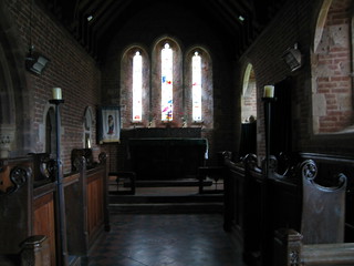
But, as mentioned in my previous blog post, there is something that makes me smile. Apparently the Exeter born historian William George Hoskins opinion of this church, was to describe it as “hideous”. I think that a bit harsh. This opinion has always been quite the opposite to my reaction. I do believe the people of Farringdon have taken this on the chin, and now wear this as a sort of rather perverse badge of honour. It’s said, there’s no such thing as bad publicity.

I didn’t stay too long at Farringdon Church, nor did I take many photos. If you wish to see more of this church, I recommend you visit my previous blog of 2014 (link above). I took a quick stroll around the church to savour its atmosphere, and then found a wall on which to perch as I ate my lunch. I then set off cycling on the next leg of my journey to East Budleigh.
The cycling this far had been relatively easy along country lanes with gentle inclines. Now my way started to climb a little more steeply as I approached Woodbury Common. A short section of this route over the common was along a rough track, which did slow my progress. It wasn’t long however before I began the descent along a country lane into East Budleigh.
East Budleigh in a nutshell: Without doubt East Budleigh’s biggest claim to fame has to be that Sir Walter Raleigh (1554-1618) was born just down the road at Hayes Barton. Apparently, ‘East Budleigh was an important settlement until the Otter ceased to be navigable.’ At the crossroads is a pillar (photo), ‘Of brick, with a rectangular stone cap bearing religious inscriptions and a cross, erected in 1580 by the Sheriff of Devon who had to order the burning of a witch at the crossroads.’ – (Devon – Pevsner) [Amazon]
Quotation: ‘To put these [Exeter] executions into context, the last case in Scotland was as late as 1727 when a witch was executed by burning. There were also the notorious witch trials in Salem, Massachusetts, which resulted in the execution of 19 alleged witches in the course of 1692-3. Across Britain the overwhelming majority (around 80%) of those accused of witchcraft during the 16th-17th centuries were female, which is borne out by the statistics for the West Country.’ (Devon Witches) [Exeter Civic Society]
See: Forensic artist reconstructs face of Scottish 'witch' (BBC News – 31/10/2017)
Witches aside, I made straight for Salem Chapel (Listed Grade II*). But, before continuing here, let me briefly mention a place brought to mind when first I saw Salem Chapel. That place is Loughwood Meeting House (NT), which I’d visited in 2014 (see blog post: 15 March 2014 - Walk: Loughwood Meeting House (8.5 Miles)). The austerity of these two places is stark. Stripped of all the usual ornamentation typically found in a church, these places seem to represent the elemental quality of devotion. And, as much as I take pleasure in the ostentatious decoration of traditional churches, I am equally charmed by the rawness of dissenters’ chapels such as these. The desire of the people to pare back the pomp and dross and re-vitalise from core belief must surely evoke sympathy. So, what is the history of Salem Chapel?
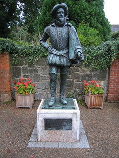
![Roger Conant (colonist) - By wagner51 (Photo by wagner51) [GFDL (http://www.gnu.org/copyleft/fdl.html), CC-BY-SA-3.0 (http://creativecommons.org/licenses/by-sa/3.0/) or CC BY 2.5 (http://creativecommons.org/licenses/by/2.5)], via Wikimedia Commons](https://en.wikipedia.org/wiki/File:Statue_of_Roger_Conant.jpg)
The name, Salem Chapel, when first I came upon it intrigued me, as I was aware of the name Salem from the play The Crucible, by Arthur Miller, about the Salem witch trials, which I’d studied many, many years ago, and once seen in London. And, yes, there is a connection between the Salem, Massachusetts, USA, and this Salem Chapel, East Budleigh, as unlikely at that might seem. The explanation is given in a caption on a noticeboard to be found in the Assembly Room: ‘Roger Conant lived in the Mill House [East Budleigh] that stood near this car park. He and his brother Christopher sailed for America in 1623 and with his followers founded the town of Salem, Massachusetts, where a statue of his stands. His descendants still keep in touch with East Budleigh.’ Roger Conant, however, had no direct connection with this chapel, since it was built later (1719).
What I did find interesting, upon further research, was the connection of witches between East Budleigh and Salem, Massachusetts. Much of Salem town’s cultural identity reflects its role as the location of the infamous Salem witch trials. To discover upon subsequent reading (see mention above) that a witch was burnt at the stake in the centre of East Budleigh, makes for a strong historical theme connecting these two places. Exeter, my home town, is also significant in this respect, in that it notoriously, was the last place in England in which a group of witches were condemned to death, by the infamous Judge Jefferies, for practising witchcraft.
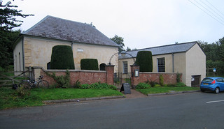
Viewed from the outside, Salem Chapel and its Assembly Room could easily be passed without a moment’s notice. Perhaps taken to be a couple of farm outbuildings. The pillared gateway to the chapel with iron trellis arch and the yew hedging perhaps being the only visual clues that here is something more than a couple of utility buildings, although Pevsner says ‘eye-catching’ of the outward appearance (eye of the beholder perhaps?).
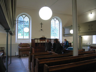
The interior is striking, in that it is a large open space, with the roof supported on a central iron pillar. It is airy, simple and elegant. The balcony, along three walls, is supported on slender iron pillars. The first floor box pews are possibly original, the ground floor pews a later addition. The central clock on the rear gallery is placed just as it is at Loughwood Meeting House. The total seating capacity is quite large. The solitary cross above the altar is about the only other decoration in the chapel. It is beautifully unpretentious.

I mentioned my curiosity regarding the derivation of the name Salem to the the lady serving tea in the Assembly Rooms. I asked if it was Biblical, as it seemed possibly so to me. The name Salem is Arabic. The Biblical Salem ‘is traditionally identified with Jerusalem’ [Wikipedia]. There are numerous places named Salem all over the globe. There is even a Salem in Cornwall.

On leaving Salem Chapel, I returned to the centre of the pretty village of East Budleigh. From there I picked up a track rising above the village. The track was rough and rutted and a little muddy, so progress was slow once again. It wasn’t long before I joined a lane and the going became easy. I then made quick time down to Budleigh Salterton on the coast. The sun was making its best efforts to put in an appearance.

Another shower of rain threatened, and therefore I wished to find a short route to the disused railway between Budleigh Salterton and Exmouth, which is now a cycle track, so as to be quickly on my way. There appeared to be a connecting path at the top end of Budleigh Salterton. My first choice [OS on DCC] was marked as ‘Path closed’ [OS on Bing Maps], but continuing up the hill a little further, I found this Permissive Path that led down to the cycle trail.
On approaching Exmouth, time had run on, so I didn’t linger. I picked up the Exe Estuary Trail and began my return journey in the direction of Exeter.

As I reached Topsham, the rain showers had cleared, and a lovely sun shone across the waters of the estuary. I paused for a quick snack and photo before embarking on the last leg of my journey home.
It’s not every day that a person out on a bicycle ride gets to see two very interesting Grade II* listed churches. It’s important to recognise the significance of that all-important ‘*’ (star) in the listing. A Grade II* listed building is very nearly Grade I, and there aren’t that many of them, therefore they can be regarded as nearly as noteworthy as Grade I buildings. It is my view, that they are always worth a visit.
Physically, it had been quite a demanding day, and come the end of my tour I was quite exhausted. The choice of my road bike had been a good decision, as I had travelled quite quickly and with relative ease.
And, so, finally, the last word goes to the witches and their witchcraft, a recurrent theme of my story today. Oddly, as much as witchcraft is despised, it seems to me, rather perversely to arise from an intrinsic human need for magic in our lives. The sense that the prosaic is not nearly enough for us, and that we need to fill our lives with greater mystery and meaning. I am reminded of the seemingly hysterical words uttered by Blanche DuBois from the play A Streetcar Named Desire by Tennessee Williams, when towards the end of that play she says, “I don't want realism. I want magic!” The question we have to ponder is, is that a streetcar that is en route to “Elysian Fields”. Sadly there was a malign and pernicious nature to the witch trials. Let’s spare a thought for the witches (past and present) this Halloween.
Walk Statistics:
Total Distance: 47.4 km / 29.4 miles
Moving Time: 4hrs 11min
Stopped Time: 52min
Total Ascent: 667 metres
Maximum Elevation: 164 metres
Buses: (none)


![Exeter Green Circle 007 [HDR - Tone Balancer]](https://farm5.staticflickr.com/4529/38331061091_5429249bd3_m.jpg "Exeter Green Circle 007 [HDR - Tone Balancer]")
![Exeter Green Circle 013 [HDR - Tone Balancer]](https://farm5.staticflickr.com/4555/24460790288_0bd9c6a372_m.jpg "Exeter Green Circle 013 [HDR - Tone Balancer]")
![Exeter Green Circle 022 [HDR - Tone Balancer]](https://farm5.staticflickr.com/4529/38331030091_711554a057_m.jpg "Exeter Green Circle 022 [HDR - Tone Balancer]")
![Exeter Green Circle 033 [HDR - Tone Compressor]](https://farm5.staticflickr.com/4548/37616507714_8f9023bae6_m.jpg "Exeter Green Circle 033 [HDR - Tone Compressor]")


![Exeter Green Circle 010 [HDR - Tone Balancer]](https://farm5.staticflickr.com/4515/24460820128_4e36d0f91d_n.jpg)
![Exeter Green Circle 025 [HDR - Tone Compressor]](https://farm5.staticflickr.com/4563/26556776359_cd6781240e_n.jpg)

