Saturday, 11 July 2015

11 July 2015 - Walk: Tavistock to Bere Alston, bus out, train return (9.5 Miles)

Synopsis: A walk along the perimeter of Dartmoor. Tavistock is a lovely place, that I’m only now beginning to discover. Double Waters, the confluence of the River Walkham and the River Tavy, is idyllic.

GPS Tracklog Download (.gpx) Microsoft OneDrive -:- Google Drive


Tavistock to Bere Alston 002Tavistock to Bere Alston 007Tavistock to Bere Alston 035Tavistock to Bere Alston 039Tavistock to Bere Alston 068Tavistock to Bere Alston 102
(selection of photos from Flickr photo set – use link above to view album)

I was looking at the bus map for Devon on the previous day to this walk, just scanning it for interesting destinations. In doing so, I noticed the 82 bus served Tavistock, a place I’d cycled through a few weeks previously, and thought an interesting place I’d like to explore more. In thinking about how to make a walk out of this, I realised the rail route between Plymouth and Gunnislake wasn’t far away. I toyed with the idea of taking in one of the National Trust properties (Buckland Abbey and Cotehele) nearby, but this would have been difficult, so in the end settled on this walk from Tavistock to Bere Alston.

Bus services to Tavistock are few and far between. There was only one bus I could catch for this walk, the 82 leaving Exeter at 10:25. It’s a mighty journey for a bus, lasting just over two hours, but I was happy to sit back and enjoy the scenery of the journey. There were only five passengers on this bus. The view seems to be that this service is doomed to be deleted, so it was just as well I was making this trip today.

Tavistock to Bere Alston 001
[Tavistock]: bus station

On alighting from the bus in Tavistock (12:35 arrival), I immediately caught sight of a small kiosk selling pasties. Just the ticket, as that way I could keep my sandwiches for supper later in the day. I cut down Canal Street where I saw an information notice board with information about the Tavistock Canal. Not surprisingly, the canal is to be seen running under Canal Street. Despite having been nearby on several occasions, this was the first time I’d taken note of the canal. It isn’t large, being, I imagine, just the width of a canal barge.

Tavistock to Bere Alston 011
[Tavistock]: River Tavy - Abbey Bridge


I followed a path along the banks of the River Tavy, eating my pasty as I went, up to Abbey Bridge, where I crossed the river. It’s very picturesque and serene by the river, and I noticed a number of benches set under trees, which would have made, had I the time, a cool place to rest and relax. Instead, I continued on my way, crossing over the river once again, this time on a footbridge, which led me into Meadow Lands park.

Tavistock to Bere Alston 014
[Tavistock]: Meadow Lands park - Tavistock Canal


I could see what looked to me like the bank of the canal, so I made a slight detour to take a closer look. That was indeed what it was. Nice to see that the old canal, at least in part, still exists today, long after its working life had expired. This is the Tavistock Canal, which provided a valuable service for the industry of Tavistock and its environs for more than forty years. Now, it is just a haven for ducks, and of course the children who feed them.

Tavistock to Bere Alston 016
[Tavistock]: The Bedford Cottages Workers cottages built by the Dukes of Bedford between 1845 and 1865.


At the furthest reach of the park, I walked out onto the busy Plymouth Road whereupon I came across quite a number of old cottages. I should imagine they’re either old workers cottages, or alms houses. They’re very picturesque, and, once again, it’s lovely that they survive to this day. In fact one was for sale. I was sorely tempted to enquire. There is talk of the old rail link with Plymouth being re-instigated, which would make Tavistock a very attractive commuter place to live (‘David Cameron says Okehampton railway line is 'most resilient'’ – BBC News 30/01/2015).

Tavistock to Bere Alston 020
Lane heading south out of Tavistock


On my way out of Tavistock, I passed near to Morrison’s, so I popped in for a couple of yoghurts for later. Then, it was a matter of following a lane, which forms part of West Devon Way, described as a ‘waymarked walking route’, but I have to confess, I didn’t see any waymarks as I walked part of this route today. I passed the grand old Walreddon Manor (Listed Grade I) (snapped) on my way along the lane.

Tavistock to Bere Alston 022
West Down - car parking is limited

Since my way out of Tavistock was along this lane, the latter part of which is clearly marked as a dead-end, I was surprised by the amount of traffic on the road. All became clear when I reached the end of the lane, at the point at which a gate leads onto West Down, where, parked on the sides of the lane, were numerous cars, the owners obviously taking a stroll on West Down. Considering how popular a location this evidently is, I was a little surprised no proper parking arrangements were in place at this spot. But, anyway, many people were obviously making the best of things.

Tavistock to Bere Alston 025
West Down - Dartmoor ponies


Just a little way onto West Down the view suddenly opened up to me. I was looking across a fern covered hilltop into a valley lined with trees. It seemed the perfect place to break for a snack and a drink, and, luckily, there were some granite boulders conveniently positioned for me to select one on which to perch. I had plenty of company, as ponies were grazing nearby, and would wander by me.
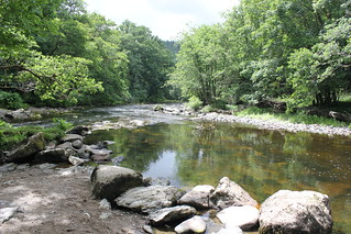
Tavistock to Bere Alston 048
Confluence of the River Tavy and the River Walkham


After lunch I continued along a very distinct track that led me down the hillside towards a point named Double Waters, the confluence of the River Tavy and the River Walkham. I’d known of this place from a visit of mine many, many years ago, and came tantalizingly close to it on a recent walk. It is an extremely beautiful spot, and it alone was sufficient to make my walk today worthwhile. I lingered a while, taking photographs as I soaked up the tranquil beauty of the spot.

I crossed over the River Walkham by way of a footbridge and continued on along the banks of the River Tavy. This led me to another lovely spot, a sharp bend in the river at a steep cliff, where, to my surprise, there was a bench complete with a ramshackle shelter. I spotted a kingfisher dart by me, its electric blue colour glinting in the dappled sunlight. I hardly need say, I failed to capture a photo of it. I did however capture this panoramic view of this pebble beach.

Tavistock to Bere Alston 061_stitch
A beautiful secluded pebble beach on the River Tavy, complete with ramshackle bench and canopy. Heaven!
Tavistock to Bere Alston 076
Approaching Berra Tor, looking back towards West Down

The track passed Tavy Cottage and began to ascend the hillside through trees before opening out onto open moorland. The high ferns somewhat obscured my way forward, but I managed to pick my way down a somewhat overgrown path just below Berra Tor.

Tavistock to Bere Alston 080
Hatch Mill


A short stretch down a dirt track soon connected me with a lane down which I continued along on my descent to once again rejoin the River Tavy near Hatch Mill. The weir that once fed the mill leat, now dry, is still shown on the map, and a path on the opposite bank leads down to it. There was some old rusting ancient farm machinery just outside the mill, standing next to a disused millstone.

Tavistock to Bere Alston 087
River Tavy - a short distance downstream from Hatch Mill


This is a lovely spot, as the path hugs quite closely the course of the River Tavy at this point. On a summer’s day like today, with the sun glinting off the water, this was the perfect place to be. I passed another, somewhat ruined, weir, with waterwheel chute, but no buildings remained at the site.

Tavistock to Bere Alston 096-HDRx54x54x34x30x16x18
Denham Bridge over the River Tavy


Following a lane for a short distance, I was soon at Denham Bridge. I’d been here before, but approached along the opposite lane, from Buckland Abbey, on a recent walk. Like then, I knew I would now have to climb the quite steep hill up the lane from here. The lane is a little busier than one might expect, but walked with care, this is not a problem.

A little further along the lane I branched off right onto a footpath across fields. I then picked up a lane, passing by Mount Tamar house, and over a bridge over the dismantled railway that once connected the railway at Bere Alston to Tavistock.


Tavistock to Bere Alston 105
A superb view of the Calstock viaduct on my approach to Bere Alston

Much of the losses arising from the Beeching Cuts are to be lamented, but I feel the loss of this connection with Tavistock is such a shame. The fact that it would connect Tavistock with Plymouth, and that much of the track-bed still exists, must surely be worth a rethink. But then, what do I know? (Further reading: Bid to reopen old train line – BBC News Friday 19th September 2008.) This is a superb view of Calstock Viaduct, I do know that much.


Tavistock to Bere Alston 107
Bere Alston railway station


My way then took me along a track under a bridge that once carried this now lost railway. I was by now only a short distance from the end of my walk, the railway station at Bere Alston. How lovely it always is, I feel, to come across a railway station in the country with a service still operating. The railway buildings look, if not quite pristine, in remarkably good order considering the more than one hundred years service that they have given. The Victorians sure knew how to build to last.


It had been a reasonably demanding walk, with three quite steep hills to be climbed, giving a rather high Total Ascent (see Walk Statistics below), and the day had been rather warm and humid. I arrived about 40 minutes early for my train to Plymouth (17:49 departure), and in fact saw it come and go, as it had to run to Gunnislake prior to returning to Bere Alston. I was glad of the time to rest, relax and eat my picnic supper on the platform, which I had to myself for the majority of the time.

Walk Statistics:

Total Distance: 12.59 km / 9.5 miles
Moving Time: 3hrs 19min
Stopped Time: 45min
Total Ascent: 411 metres
Maximum Elevation: 164 metres

Buses: 82 Exeter to Tavistock £6.30
Trains: Bere Alston to Digby & Sowton off-peak single £9.90

Saturday, 4 July 2015

04 July 2015 - Walk: Hillhead to Colleton Fishacre (NT), and then to Kingswear (9.0 Miles)

Synopsis: Superb coastal path walking, but stamina required for the very steep climbs. Worth the effort. Includes the beautiful gardens of Colleton Fishacre (NT) accessed from coast path.

GPS Tracklog Download (.gpx) Microsoft OneDrive -:- Google Drive


Hillhead, Coleton Fishacre (NT) & Kingswear 009Hillhead, Coleton Fishacre (NT) & Kingswear 014Hillhead, Coleton Fishacre (NT) & Kingswear 026Hillhead, Coleton Fishacre (NT) & Kingswear 076Hillhead, Coleton Fishacre (NT) & Kingswear 117RJS-LUMIA-2520 - WP_20150704_14_57_36_Pro
Hillhead, Coleton Fishacre (NT) & Kingswear 003aHillhead, Coleton Fishacre (NT) & Kingswear 004aHillhead, Coleton Fishacre (NT) & Kingswear 005aHillhead, Coleton Fishacre (NT) & Kingswear 006aHillhead, Coleton Fishacre (NT) & Kingswear 007a
(selection of photos from Flickr photo set – use link above to view album)

This is a repeat of a walk that I did with family members, including my two daughters Helen and Laura, many years ago. No dip in the sea this time, although the water did look very inviting on this hot and humid day. Just as before, this day out was done on public transport, but this time I used a combination of train and bus. For the very first time, I made use of a Plusbus ticket. A Plusbus ticket is a supplement to the normal train ticket, and provides unlimited bus travel for the day at either the originating or destination vicinity of your journey (prices given below). Although information on the Internet suggested it was possible to purchase such a ticket at the ticket vending machine at the railway station, this didn’t appear possible, so I purchased my Plusbus ticket from the conductor on the train.

Hillhead, Coleton Fishacre (NT) & Kingswear 011
[Paignton]: A view, from the footbridge over the railway line, of the main Paignton railway station at which I had just arrived today.

A fairly early start to the day, with a 6:00 am wake-up, catching the 8:40 train to Paignton, whereupon I arrived punctually at 10:00 am. It was a lovely warm and sunny start to the day, and I enjoyed the journey down by train, as it is such a scenic route. The train wasn’t excessively busy, just a few family’s making a day out of it.


Hillhead, Coleton Fishacre (NT) & Kingswear 008
[Paignton]: A steam train of the Dartmouth Steam Railway and River Boat Company.


I had a little time to spare in Paignton before my bus for Hillhead was due at 10:30 am, so I dallied around the adjacent station of the Paignton Steam Railway company. A carriage was beginning to fill with passengers, and there was quite a long queue for tickets, so most obviously a popular attraction on this summer’s day.

Hillhead, Coleton Fishacre (NT) & Kingswear 012
Descending a tree lined track from Hillhead, where I'd been dropped by bus, towards Scabbacombe Sands.


Back to the bus station for me, to catch the 10:30 am bus from Paignton to Hillhead. Hillhead is little more than its name suggests. There are a few scattered houses and a camping site. I had to be careful not to overshoot my bus stop, for which my handheld GPS is most useful, as there’s little warning that you’re approaching Hillhead. Once away from the busy main road, a little way down a lane, the path picks up a track, and I was on my merry way.


Hillhead, Coleton Fishacre (NT) & Kingswear 023
View towards Scabbacombe Sands.


Although my walking distances today were not long, I was keen to make good progress. The reason for haste on this, my first leg, was to reach the gardens of Coleton Fishacre (NT) where I hoped to eat my picnic lunch. From Hillhead, as one might surmise, my way was down, following a track through trees for most of the way, before entering fields just above Scabbacombe Beach. A bit of a trek for those with deckchairs, parasols, buckets and spades, but a great place for quiet relaxation, if only one had the time.

Hillhead, Coleton Fishacre (NT) & Kingswear 029
Ponies on the cliff slopes at Scabbacombe Sands.


I noticed that ponies were grazing on the not inconsiderable slope of the hill I was about to climb. I believe the ponies are used as part of the land management programme for this area. It did appear to me that much of the turf had been grazed away, which I found a little startling, but I presume this is all part of the ‘strategy’.

Hillhead, Coleton Fishacre (NT) & Kingswear 039
The coastal path between Scabbacombe Sands and Pudcombe Cove, the point of entry to Coleton Fishacre (NT).


Once I had climbed to the cliff top and out on the headland, the views really opened up. And it is that which makes walking this stretch of the coast path such a pleasure. The far reaching views are simply stunning. I was also appreciative of the strong cooling breeze that I was now exposed to.


This panoramic photo gives a good impression of the views along this strech of coast.

Hillhead, Coleton Fishacre (NT) & Kingswear 052_stitcha
The coastal path between Scabbacombe Sands and Pudcombe Cove, the point of entry to Coleton Fishacre (NT).
Hillhead, Coleton Fishacre (NT) & Kingswear 059
The coastal path between Scabbacombe Sands and Pudcombe Cove, the point of entry to Coleton Fishacre (NT).

I had a couple more quite steep hill climbs to the tops of cliffs before I was finally on the approach to Pudcombe Cove, which is where the lower entrance to Coleton Fishacre is to be found. On my final approach, about a 100 metres from the entrance gate, I was able to look down into the cove, and there, far below, I could make out the ruined remains of what was once a seawater bathing pool used by the family living at Coleton Fishacre.

I took a little time out to appreciate the coastal views from Pudcombe Cove before entering the gate to Coleton Fishacre. The entrance prices are shown on this gate (although I’m a member anyway), but fees aren’t collected at the gate. One is expected, on trust, to pay at the main entrance, just above the house.


Hillhead, Coleton Fishacre (NT) & Kingswear 063
[Coleton Fishacre (NT)]: Tree ferns


The first thing that immediately struck me on entering the gardens was how marvellous the tree ferns were looking. There are also areas of swamp garden near the stream that trickles down the centre of the garden, these areas containing such plants as gunnera and skunk cabbage.

Hillhead, Coleton Fishacre (NT) & Kingswear 067
[Coleton Fishacre (NT)]: A stream runs down the valley in which the house and garden are to be found


The benches I came across on meandering through the delightful gardens were all in the sun, so instead, I settled (literally) on a spot on the lawn under the shade of a tree to eat my lunch. What was immediately evident to me was that, despite a significant breeze on the coast path, here, in the shelter of this valley, the garden sits in a sheltered suntrap which was very warm. It’s easy to see why the plants love this garden.


Hillhead, Coleton Fishacre (NT) & Kingswear 084
[Coleton Fishacre (NT)]: Lampranthus

After lunch, I strolled around the gardens closest to Coleton Fishacre house. I walked out to a viewpoint that looks down the length of the garden and out to sea. Stunning! The most striking plant in the garden at this time was probably the patches of lampranthus, which were very vivid in colour, almost electric.


Hillhead, Coleton Fishacre (NT) & Kingswear 088
[Coleton Fishacre (NT)]: Beschorneria - Wikipedia


Oh! and I discovered they also have a Beschorneria Yuccoides. This is me showing off newly acquired knowledge. The best example I’ve seen of this plant is that to be found at nearby Greenway (NT) (see: Greenway, Torquay 014), seen a few years ago, but it has taken until now to discover the name of this plant.

Hillhead, Coleton Fishacre (NT) & Kingswear 095
[The Daymark]: "The Daymark is 25 Metres high, and was built in 1864 as a navigational aid. It is owned by the Dartmouth Harbour Commissioners." - From nearby information board.


I duly had myself accounted for at the main property entrance kiosk, for, despite being a member of the National Trust, the property claims an amount for my visit today. I then climbed the lane to the brow of the hill, and headed along an adjoining lane in a south-westerly direction. Part of the reason for my choosing this route was that I wished to take a close look at the daymark to be found along the way. This is clearly visible from the coastal path, from which I’d seen it on numerous occasions, but a closer inspection was long overdue.


Hillhead, Coleton Fishacre (NT) & Kingswear 098
[The Daymark]: Looking out from the centre of the daymark


The daymark I speak of is to be found just inland of Inner and Outer Froward Points. Of its type, I think it one of the most elegant, almost a work of art. Built in 1864, it is 25 metres tall, and is most imposing, and oft photographed, which didn’t stop me taking yet another. Well, the light was near perfect for a photograph, so that’s my excuse. Another daymark I’m aware of is that to be found in Cornwall, at Gribbin Head (see: Par to Fowey 056).

Hillhead, Coleton Fishacre (NT) & Kingswear 101
[The Daymark]: The view looking towards Dartmouth


I was soon back on the coast path once again, having skipped a section from Pudcombe Cove, missing a number of steep ascents (I hear you cry ‘cheat’). From Inner Froward Point the path drops through trees until it reaches Mill Bay Cove. I was dreading reaching here! I know well enough from past experience, the worst climb of the day is steeply up steps from this point. Somehow, despite a struggle, I got to the top.

Hillhead, Coleton Fishacre (NT) & Kingswear 112
Mill Bay Cove and the mouth of the River Dart viewed from the coastal path.


Just off the coast from here is to be found the remains of Gomerock Tower. This was the place from which a chain was once draped across the entrance to the River Dart, reaching from here to Dartmouth Castle (EH). The precise location is shown on this map from Historic England, but, unusually, no further information is shown on this page.

Hillhead, Coleton Fishacre (NT) & Kingswear 118
[Kingswear]: House with a view


From here I began to enter the outskirts of Kingswear. I noticed I’d come slightly high and away from the coastal path, but on dropping lower to pick it up again, I came across a sign indicating the path was closed, due to a cliff fall. There have been many in the South West over recent years.

Hillhead, Coleton Fishacre (NT) & Kingswear 121
[Kingswear]: The steam railway station


It wasn’t long before I was down in the centre of Kingswear. A quick check of my watch and I became aware I’d just missed the 16:00 bus, and had a little over an hour to wait for the next bus. That suited me fine. I took a moment’s rest and a drink on a bench on the railway station platform. I then wandered along the platform, watching a huge, 12-carriage train, pulled by an enormous diesel engine, pull out from the station. All the carriages appeared to be dining cars. I assume it was some form of charter.

On reaching Paignton I found that my train was a bit delayed, which gave me time to rest and eat an apple whilst I waited on the station platform. It wasn’t long before I was on my train and headed home on a busy, but not overcrowded, train. I was quite tired, but had enjoyed the day very much. If you have the stamina, this is a great day out from Exeter.

Walk Statistics:

Total Distance: 14.5 km / 9.0 miles
Moving Time: 3hrs 39min
Stopped Time: 1hr 16min
Total Ascent: 581 metres
Maximum Elevation: 166 metres

Buses: 120 (Paignton – Kingswear)
Trains: Digby & Sowton / Paignton off-peak day-return (FGW): £7.30 + £2.50 = £9.80
(Purchased train ticket from vending machine, Plusbus ticket from conductor on train)