Synopsis: A walk around a cycle trail in Torquay that has never been formally opened, nor will it ever be. But it exists, and is navigable, and can be negotiated (with care), and is actually rather good.
The photo album that I have created for this walk includes photos of all the route markers that I could find as I went about my hike. If you wish to see only the photos of views without the signage, this can be done by using the Flickr filter ‘Photo Set Without Signage’. Please note that some of the route markers contain, in addition to the marker number, an information panel. Wherever I have come across one of these I have also photographed it and included it within my Flickr photo album.
The reason for this walk today was the discovery, whilst out on a previous walk (see: 18 June 2015 - Walk: Torquay to Totnes - John Musgrave Heritage Trail (9.0 Miles)), during which I came across a route marker that indicated, what seemed to be, a cycle trail. I made enquiries of the Torquay Tourist Information office, but drew a blank. Today I walked the entire route as was originally intended, and I can see why my enquiries drew a blank. This was a planned trail that was never seen through to completion, and from what I saw today, never will be. There are still some route markers and information panels remaining in the countryside, but a number have been removed. I now understand why Torquay Tourist Information had no knowledge of this cycle trail when I communicated with them a couple of months back.
Firstly, let me describe my walk today. I’ve added a section ‘Should you cycle this route?’ (see below) with my thoughts on that. I had travelled by train today, arriving at Torquay station, and departing from Paignton, which explains the additional mileage in my statistics. In hindsight, I now realise I didn’t walk the most direct route to the start point from Torquay railway station. Ah well, it was a very pleasant route, so I wasn’t too perturbed by that (Google Maps suggested cycle route).
The trail follows a well laid, wide and even route for the entire 7.2 mile course. The early part of the trail is through Ten Acre Brake woods, which is very tranquil and pleasant.
Whilst walking by the stream the runs down this vally, I came across part of what I presume to be an old pump. Ok, this next paragraph is a bit of an aside, but I have developed rather a nerdy interest in this subject, so you’re going to have to excuse my ramblings, or move on.

The pump that I came across I think could be what is known as an hydraulic ram [pump], or at least part of one. I’m no aficionado on this subject, so I can’t be certain. If it is this type of pump, then the purpose of it would be to use the flow of water down the valley as a force to ‘output water at a higher hydraulic head’ than that of the level of the pump. In such a situation as this such a ram is often useful, since it requires no outside source of power other than the kinetic energy of flowing water. If I should be wrong in my interpretation of what this is, then I’d be happy to be put right on the subject, so do please let me know.
A little further along the trail I came across the entrance to ‘Scadson Wood Bike Park’. I didn’t explore further, as I wasn’t on a bike. I think if I had been cycling, I’d have been tempted to investigate. One for another day.
The trail continues up a gentle incline until it approaches the Cocking Road/Totnes Road lane. The trail runs adjacent to the lane, not along the lane, making the approach to Occombe Farm very safe.
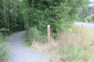
From this point the trail proper appears to run through Occombe Farm car park, which I didn’t realise until I was walking onwards. Then a busy road has to be crossed, and a little further along the trail, past Occombe House, an even busier road is traversed by way of an underpass. Coming out the other end, near a route marker (A8), I crossed yet another road. At this point I came across a secluded bench, and therefore broke for lunch.
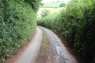
The trail then follow what appears to have been an old road that runs adjacent to the extremely busy main road in use today. Some parts of the way made for pleasant walking, but other sections have been used as a dumping ground, with waste spewed everywhere, which isn’t particularly pleasant. I am surprised its tolerated by the council. A little way further along I branched left into a lane, Widdicombe Lane, that dropped quite steeply. It was very narrow, which made it difficult to pass oncoming traffic.
I then branched right onto another lane which began to ascend gradually. There was this gate (see photo)across the lane, which at first seemed rather bizarre. But now I think it has something to do with the lane being private. It’s odd that a trail should direct you onto a private lane. Anyhow, nothing seemed to impede my progress as I proceeded up the lane, through an underpass of the A380 road, eventually reaching a stile leading into a field.
On entering the field, the views suddenly opened up to me, and I could see over Torquay and out to sea. This extensive and glorious view was something of a surprise to me, and very welcome it was too. It truly illustrates the potential this trail once had.
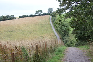
This is the highest point on the trail.From here the trail follows field boundaries, dropping gradually on the approach to the village of Cockington. There is this one rather steep sided valley to be negotiated. Good brakes would be required at this point on the trail.
The route doesn’t actually enter Cockington village, but it comes closest to the village at this point (see photo), when the Drum Inn comes just into sight. This would be the best point at which to deviate from the route to explore Cockington village. From here the route leaves the lane and proceeds along a track up the hillside. About 2/3rds of the way up the hillside there is a path to the left which leads into Cockington Court.
This is the last route marker, ‘A24’, that one sees on this trail. From here navigation along the return route back to the start is very easy. One first reaches route marker ‘A3’, the point of connection with the route out, from where one backtracks to the trail start point.

On completion of the cycle trail, I had one further objective in mind, should time allow, and that was a visit to Kirkham House (Grade II* Listed). A quick map check informed me I was 1.5 miles/30 minutes from Kirkham House, which gave me plenty of time for a visit. I’m glad I did, as the house is a rare and wonderful survivor. It isn’t often open, so it was important to make the most of this opportunity.
My walk today, of this intended ‘cycle trail’, the Cockington Valley Loop, proved an enjoyable endeavour in its own right. I discovered a little of the state of the trail in doing so, which may be of interest to others. My visit to Kirkham House was the icing on the cake.
Should you cycle this route (personal thoughts)?
[Important – see addendum below]
So, should anyone be reading this post with an interest in cycling this trail, what is the current position? Well, firstly anything I say is of course entirely unofficial, and must be taken as such. The trail had been well laid out and all parts can be cycled with care. It is my view that this is actually a good trail, but I can see why it will, in my estimation, and and bearing in mind some signage has already been most emphatically removed, never become official. There are, in my opinion four obvious reasons for this routes demise, at least officially, which are as follows:
-
There are some sections of the trail, although wide and even, to the side of which there is a steep drop, and these sections have not been fenced to improve safety.
-
There is one particularly steep drop into and out of a valley, which if cycled (walking with bicycle would be safer), would require particular care.
-
Part of the trail traverses what seems to be a private lane (based on signage that I saw on my walk today), although I can’t vouch for that one way or the other, and today I used this route without a hitch.
-
The direction of travel around the route (clockwise) involves going, for a short distance of about 200 metres, the wrong way down a one-way road, which, to remain, safe and legal, would need to be walked.
So, having said all that, would I cycle it? Yes, I would, because, despite being far from perfect, it would make for a good ride. And, bearing in mind that Torbay has very little to offer the cyclist (there are no comparable trails in this area), this is the best you’ll find. So, the choice, and any associated risks, have to be entirely yours. My route, as walked today (available from links on this post) may be used as a route guide and could compensate for the places where signage has been removed. Or, you may use Cockington Valley Loop, the route as I’ve plotted on Bing Maps, the accuracy of which I’ve improved based upon my findings today.
I’ve included below both statistics for the Cockington Valley Loop section and for my entire walk route today, which includes walking to-and-fro the railway stations at Torquay and Paignton. The post heading mileage and the map links in the sub-heading of this post refer to the Cockington Valley Loop section, and not the entire walk that I undertook today.
Missing or Uncertain Route Markers:
-
Route Marker: 'A5' (missing)
-
Route Marker: 'A7' (missing)
-
Route Marker: 'A14' (uncertain)
-
Route Marker: 'A15' (uncertain)
-
Route Marker: 'A16' (uncertain)
-
Route Marker: 'A17' (uncertain)
-
Route Marker: 'A19' (uncertain)
-
Route Marker: 'A20' (uncertain)
[Addendum 25/09/2017]: Things appear to have moved on in the two years since the time of my having walked this planned cycle route, as described in this post. At that time, the route appeared to have been shelved, with visible evidence of signage having been removed (see my photos). It appears that the cycle route has now been reinstated under the new name, ‘Geopark Cycle Loop’ (see: ‘Torbay Cycle Map’), although I believe there have been some minor alterations to the route as I have described here in this blog post. Recognition on this map does give renewed legitimacy to this cycle route. I also note that the cycle trail, as of 2017, is now shown on OpenStreetMap (Cycle Map Layer), The start point for the trail (the point from which I started in 2015) is shown from this link: Geopark Cycle Loop starting in Cockington Lane/Old Paignton Road. This map can be viewed on a smartphone, which should provide a valuable aid to navigation whilst on the trail.
Walk Statistics [Cockington Valley Loop]:
Total Distance: 11.6 km / 7.2 miles
Elapsed Time: 4hrs 03min
Total Ascent: 425 metres
Maximum Elevation: 148 metres
Walk Statistics [Entire walk including Cockington Valley Loop]:
Total Distance: 21.9 km / 13.6 milesMoving Time: 4hrs 45min
Stopped Time: 1hr 11min
Total Ascent: 646 metres
Maximum Elevation: 148 metres
Buses: (none)
Trains: Digby & Sowton to Paignton – off-peak day return: £7.30


No comments:
Post a Comment