Saturday, 14 May 2016

14 May 2016 - Walk: Bovey Tracey (9.0 Miles)

Synopsis: A walk from Chudleigh Knighton to Bovey Tracey. Includes Chudleigh Knighton Heath and Little Bradley Ponds. Also a glimpse of Blue Waters Pond, previously a coal (lignite) mine.

GPS Tracklog Download (.gpx) Microsoft OneDrive -:- Google Drive
 
 
Statistics and tracklog overlay on Open Street Map (OSM) and Open Cycle Map (OCM) Runtastic
 
Bovey Tracey 011Bovey Tracey 022Bovey Tracey 025Bovey Tracey 035Bovey Tracey 051Bovey Tracey 056
(selection of photos from Flickr photo set – use link above to view album)

Spontaneous walking. I think that best describes today’s walk. I normally map out my route in fine detail and load it to my GPS, as this makes walk navigation on the day very easy. But today, I simply glanced over Ordnance Survey mapping, and checked bus times out of Exeter, and set about my walk. In part, I wanted to allow myself the freedom to explore just exactly where I could and could not walk, which wasn’t entirely evident from maps. I had in mind two features that I’d like to include in the walk, Devon House and Blue Waters Pond, both of which I explain below.

Recently I’d visited the heath lands in this area on a walk with some ex-colleagues of mine. We didn’t have time on that walk to explore all that I hoped (too much talking and not enough walking I’m afraid). So, at least in part, motivation for today’s walk arose from that previous visit.

Bovey Tracey 001
[Chudleigh Knighton]: The Claycutter's Arms (was there only one claycutter?)

The bus from Exeter that I travelled on dropped me as planned at the Anchor Inn bus stop in Chudleigh Knighton. The first observation that I made today was, there’s no Anchor Inn here. It had been demolished. I could recollect vaguely what it had looked like, and I remembered noting that it looked a little run down. Well, it is now entirely run down, just a pile of rubble. Apparently pubs are closing at a great rate right across the country. I passed this, the Claycutter’s Arms, in Chudleigh Knighton, with seemingly a better fate.

Bovey Tracey 002
[Chudleigh Knighton Heath]: Information board showing Ant Trail


I followed the road out of sleepy Chudleigh Knighton. On the outskirts of the village, there was an information board for Chudleigh Knighton Heath which showed me where I was and the direction in which I needed to walk. Apparently, I would be walking on the Ant Trail. There are some rather peculiar ants on the heathlands in this area, so I’m led to believe. There are way-post markers that dot the trail, so route finding was easy.

Bovey Tracey 005
[Chudleigh Knighton Heath]: Connecting path to the left of my walk along the Ant Trail


I reached a point where there seemed to be a connecting path to my left that I thought might exist. This path I assumed to connect with the previous walk I’d done with my ex-colleagues a few weeks ago. I decide to explore the path to see if I was correct in that supposition, with the intention of walking out and then returning to this point.

Bovey Tracey 008
[Chudleigh Knighton Heath]: Quiet and peaceful, and the place to myself


And yes, just as I expected, the path I followed led me to a point that connected with my previous walk. It was lovely and peaceful out on the heathland, with not a soul about. The trees all about in the bright colours of their new foliage. It’s a great time to be in the country.


Bovey Tracey 012
[Chudleigh Knighton Heath]: Lots of Early Flowering Purple Orchid (Orchis Mascula) [Wikipedia]


Returning to the point of my path of primary intent, I continued along this, heading roughly in the direction of Little Bradley Ponds. This is a nature reserve managed by Devon Wildlife Trust. I was approaching from a new direction requiring me to explore navigation options as I went. Part of the way could be walked along a path on the edge of woods, but after a while it was necessary for me to return to the road and walk, with extreme caution, down hill to where the entrance to Little Bradley Ponds was to be found.

Bovey Tracey 014
[Little Bradley Ponds - [Devon Wildlife Trust]]: Still waters


Choosing the left lake to explore first, I set off on the perimeter path that encircles the lake. One of these lakes is apparently an old ball clay works. I think it is not this first lake, but the lake across the road from it. The path around that other lake looks white and appears like clay.


Bovey Tracey 016
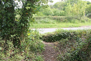
[Little Bradley Ponds - [Devon Wildlife Trust]]: Possible point of entry to the ponds, but involves scrambling over a low wall

Part way around the lake I was encircling I noted a path off to my left. I decided to explore where this led. There are no clues on maps as to where this path might lead. Climbing along this path for a while I eventually discovered that it led out to the road along which I had just walked. There is no ‘official’ entry onto this path, and in fact there is a wall at the point where the path connects with the road, but is clearly used by some people as an entry to the lake. If I’d known it was there, and was prepared to climb the wall (about 0.8 metre high) I could have avoided the need to have walked some of the road I’d just traversed.

Bovey Tracey 020
[Little Bradley Ponds - [Devon Wildlife Trust]]:


Regaining the path around the lake, I was now at the highest point along this path. The path is narrow and winds it’s way through small trees and scrub, but is easy to progress along. I was soon descending once again, and it wasn’t long before the lake, or should I say pond, came into sight once again.


Bovey Tracey 025
[Little Bradley Ponds - [Devon Wildlife Trust]]: Lots of Water Lilies (Nymphaeaceae) [Wikipedia]


Completing the circuit of this first lake, I was back at the road where I could enter the opposite lake. This lake, slightly larger than the first I’d walked, has a perimeter path like the first. Part way into this walk I once again noticed a path off to my left, and once again, decided I’d like to explore. I had noted from having previously perused a map of this area, that there was another lake nearby. I came upon a stream to be negotiated via a collapsed bridge, but once across this, another lake came into view.

Bovey Tracey 029
A pond that is close to Little Bradley Ponds.

I’d previously visited the first two lakes I mention here, but this lake I’d not seen before. It was clearly a lake for fishermen, as all around it can be found numbered fishing stations. I followed the path in a south-easterly direction eventually reaching a path intersection point with a path leading off left across fields. At this point I realised that I was on a public footpath I’d seen earlier on the map. There is a sign on the lake perimeter path that says fishing permit holders only are permitted to proceed further along this path. I was happy to return the way I came, as I now wished to follow this public footpath in the direction of Bovey Tracey.

Entering Bovey Tracey I picked up Combe Lane, which in turn led me to a road named Devon House Drive. This left me in little doubt I was headed in the right direction. The ‘drive’ is now lined with bungalows. As I walked along this road Devon House and its grounds came into sight. I could immediately see how similar this building was to other such Victorian institutions of this period, with a sturdy looking building located in grounds planted with various cedars. Quite peaceful and elegant in its own way.


The building was previously known as Devon House of Mercy. It was run by nuns, and was meant to be a sanctuary for ‘penitent’ or ‘fallen women’. A laundry service was operated from the institution. In many ways, I presume this to be not unlike the infamous Magdalene Sisters, the story of which was made into a film about ten years ago. I’d recently re-watched the film, which reminded me of the horrors practised at such inhumane institutions. I suppose that piqued my interest in visiting this place.


Devon House is now flats. One of the residents was decidedly unfriendly and asked me what I was doing. I explained I was simply walking through and taking a few photos as I went. Effectively, he told me to bugger off, despite my protestations, saying I was doing no harm. One of the last relics of the Miserable English so wonderfully portrayed by John Cleese all those years ago. Shame they don’t recognise themselves.
Bovey Tracey 043
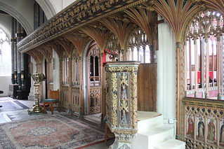
[Bovey Tracey]: St Peter and St Paul and St Thomas of Canterbury (Listed Grade I) [Historic England List] Fifteenth century rood screen and medieval pulpit

Picking up the public footpath that leads off from Devon House back in the direction of Bovey Tracey, I descended the hillside, and re-joined the road near to the parish church of St Peter and St Paul and St Thomas of Canterbury (Listed Grade I). I took a little time out from my walk to visit the church, as I usually do. It has an absolutely amazing rood screen. The pulpit is very impressive too.


Bovey Tracey 050
[Bovey Tracey]: St Peter and St Paul and St Thomas of Canterbury (Listed Grade I) [Historic England List] - water trough in the stone wall by the parish church


Outside the church I found myself looking for golden frogs. There is a small water trough set in the wall below the church, which today is dry. There is an ancient legend of golden frogs that surrounds this water trough, a delightful legend, which can be read about on the Legendary Dartmoor web site.


Bovey Tracey 052
[Bovey Tracey]: My picnic lunch spot, a bench by the River Bovey


I continued my walk, entering the main street of Bovey Tracey, busy today, in part because there was a local market taking place. It was just a little after midday and I was getting to be a tad hungry, not least because I’d had an early breakfast. I knew there was a park by the River Bovey at the lower end of town, not far from the old mill, that I thought I’d seek out. And, just as I had hoped, there on the banks of the river was the perfect park bench, an ideal stop for my lunch break. I sat and watched the grey flycatchers catching their lunch as I ate mine.

Bovey Tracey 054
[Bovey Tracey]: The Church of St John the Evangelist (Listed Grade II*) [Historic England List] - monument to 3 sisters (echoes of Macbeth here), who drowned on the River Nile in 1875 [link]

After I’d eaten my lunch I backtracked to the road bridge over the River Bovey. From here, a public footpath led me away from the car park and up the hill. A little way further and I came across The Church of St John the Evangelist (Listed Grade II*). Initially, although noting the pleasing aesthetics of the church, it had been my intention to merely walk by, when I noticed a substantial monument in the church cemetery. It immediately occurred to me that this was the monument that I’d been mistakenly looking for in the church of St Peter and St Paul and St Thomas of Canterbury, visited earlier.

Previous to my walk today I’d read the story of the deaths of 3 sisters (echoes of Macbeth here), Emily Gurney, b.1843, Lutterworth, Leicestershire, Rosamund Gurney, b. 1851, London and Mary Gurney, b. 1855, London (Ancestry Message Boards). They were daughters of Rev. John Hampden Gurney, Prebendery of St Paul's Cathedral. The sisters all drowned in the River Nile in 1875. Apparently a storm blew up and the boat they were on capsized. If you wish to read more of this story I recommend you visit the blog post ‘Russell Gurney (1804-1878) and the Melancholy Accident’ by Colin Salter. This includes an extract from the New York Sunday Courier for 30th January 1876 which recounts the story of this tragic accident.
Bovey Tracey 067
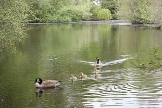
[Bovey Tracey]: Pottery Pond and Canada Geese

Moving on, I Picked up a public footpath that followed the banks of Pottery Pond. This, as its name implies, was a pond created to power the once thriving pottery industry of Bovey Tracey. This pond alone powered five water wheels. Today it is the tranquil preserve of ducks and geese. A family of Canada Geese with fluffy goslings waddled by as I too waddled on my way.


Bovey Tracey 075
[Bovey Tracey]: Blue Waters Pond - previously this was a lignite coal mine


The bigger pond that I was seeking out was that named Blue Waters Pond. I was curious to see this as it was once a working coal mine. At one time lignite, a low grade coal, was mined here, well into the middle of the 20th century. I suspected that I would only be able to glimpse the pond as I was fairly certain that unfortunately there is no public access to its shores. This was driven home to me by an ‘Only site residents allowed by this lake’ sign posted on the boundary to the lake. Still, I did at least manage to catch this view of the Blue Waters Pond.

Bovey Tracey 078
Templer Way running through the tranquil Great Plantation

At this point in my walk was on the Templer Way designated walk route. It was necessary for me to walk some length (about 1.4 kms) of this walk route along a road, which required some care. Eventually, near Belle-vue, the route left the road and entered woodland. This was a quiet tranquil place, a delight to walk through.

I was headed for Drumbridges Roundabout, as there are bus stops on this roundabout from where I would be able to catch a bus home. Unfortunately my timing wasn’t brilliant, as I’d have to wait nearly an hour for a bus. There was however a comfortable shelter in which I could sit and await my bus.

It had been not a very long walk, nor was it that demanding, but it had been a walk that had much variety in it. I’d achieved my various objectives for the outing, and had had a relaxing and enjoyable day’s walking. The countryside was looking crisp and fresh in its spring habit.

Walk Statistics:

Total Distance: 14.49 km / 9.0 miles
Moving Time: 3hrs 47min
Stopped Time: 46min
Total Ascent: 178 metres
Maximum Elevation: 75 metres

Buses: 39 & H

Saturday, 16 April 2016

16 April 2016 - Walk: Totnes to Ashprington (8.8 Miles)

Synopsis: I was in Totnes the previous week, but on the opposite side of the River Dart. Today’s walk was a short trek to Ashprington. A brief visit to Totnes Castle (EH) prior to setting out from Totnes.

GPS Tracklog Download (.gpx) Microsoft OneDrive -:- Google Drive
 
 
Statistics and tracklog overlay on Open Street Map (OSM) and Open Cycle Map (OCM) Runtastic
 
Totnes to Ashprington 006Totnes to Ashprington 008Totnes to Ashprington 014Totnes to Ashprington 016Totnes to Ashprington 020Totnes to Ashprington 024
(selection of photos from Flickr photo set – use link above to view album)

As mentioned in the synopsis for this blog post, I was in Totnes one week previous to today, and at that time looked at a map and noticed that there was part of path the on the western side of the River Dart that I had not walked. I also noted that it formed part of the John Musgrave Heritage Trail, parts of which I’ve walked on numerous occasions. I decided then and there that I’d like to make a repeat visit to Totnes to this walk.

Totnes to Ashprington 001
[Totnes]: Railway Station

Whereas last week’s walk was done by bus, today’s walk I decided to do by train. Since my start and end point would be Totnes, that would be easy to achieve. It only takes me about an hour to get to Totnes by train (exact times are shown below). This is a really convenient destination for me.


Totnes to Ashprington 005a
[Totnes]: Castle - 'The Shell Keep' (aerial view of Totnes - detail) [EH Information Board]


On arriving at Totnes station I made my way across Totnes to Totnes Castle (EH). Since I am an English Heritage member (having subscribed last year), I thought it worth making a brief return visit to the castle prior to my setting off on my walk. It’s a great little castle with a tremendous view over Totnes and the surrounding landscape. I chatted for a while with the very friendly EH steward in the visitor’s kiosk. This image (left) I grabbed from an information board. The aerial view shows the castle in relation to the town and river.

Totnes to Ashprington 009
[Totnes]: A view from the track climbing out of Totnes heading in the direction of Ashprington

After having visited Totnes Castle, I continued up the hill out of the back of Totnes. It was a bit more of a climb than I’d at first anticipated, so I took it steady. I was at least aware that this would be my one and only climb of the day, therefore it made sense to not rush at it. The narrow winding street soon gave way to become a dirt track from which the whole of Totnes could be seen.


Totnes to Ashprington 012
Sun and shade plays on the countryside between Totnes and Ashprington


Mud? Yes, there was some considerable mud in places. At this time of year I expect that. Nothing obstructed my progress. Eventually I joined a lane and at that point my climbing was largely behind me. I followed this quiet lane along the hill ridge lined with Monterey Pines, heading in the direction of the village of Ashprington. The sound of whistles from the steam trains on the South Devon Railway accompanied as I went on my way.


Approaching the village, I diverted from the lane to pick up a track that followed the contours of the hill. This was the most direct route for a pedestrian into Ashprington, but, once again, there was considerable levels of mud to be waded through. I did wonder if I’d arrive in Ashprington in a fit state to be able to visit the church.

Ashprington is a very pretty village. I’d last visited it on a walk way back in 2008, and recalled it’s appearance from that time. I was snapping a few photos when a girl on a bicycle whizzed by, coming out of nowhere. She reminded me of my youth, along with my brother and a friend, spent in a small village, never without our bicycles.


Totnes to Ashprington 015
[Ashprington] Church of St David (Listed Grade I) [English Heritage List] - and war memorial - look closely, and you will just see my lunch bench at the top of the hill, next to the entrance to the church


There were benches in the village centre, but I caught sight of a bench up on the hill by the entrance to the church, which I took a fancy to. I supposed it would offer a fine view down the village and far beyond to the hills in the distance. I was absolutely right in this supposition. The bench made a perfect lunch stop.

The girl on a bicycle, mentioned above, rode by, and stopped to chat for a while. She told me she’d lived in the village all her life, all eleven years of it. She told me she liked living there. It wasn’t hard to see why.


After having eaten my lunch I walked into the church cemetery and attempted to scrape what mud I could from my boots. I concluded I was just about presentable enough to enter the church. I wouldn’t class the church as vastly interesting, since it had obviously had a heavy-handed restoration done to it. I think I liked the carved reredos best of all.

Totnes to Ashprington 026
Views of the River Dart along the trail from Ashprington to Totnes


From Ashprington Church, I had to climb a little further up the hill in the direction of Sharpham. I passed the gates which I supposed to be the entrance to Sharpham House. I discovered at this point that a cycle trail has been laid between Totnes and Ashprington. Although not quite the route that I had originally plotted, I decided that I would follow the cycle trail as much as was practical, since this was a good surface to walk, was not too steep, and afforded good views out over the River Dart.


It was interesting to watch the various craft sailing up and down the river as I walked. It’s a very pretty stretch of river. Some parts of the River Dart are not very accessible to the public. It’s nice that this stretch of the river is easily reached from Totnes and that it affords such lovely views.

Totnes to Ashprington 028
[Totnes]: The quay in Totnes (I was on the opposite bank the week previous

As I approached Totnes I could make out the path I had walked the previous weekend. Today, there was some form of rowing event taking place on the river, and various row boat crews were rowing in the Totnes direction. I heard one young boy on the far bank shouting, ‘Come on Grandpa,’ evidently proud of his antecedent’s exploits.

I arrived back in Totnes with plenty of time to spare before needing to catch a train home. I decided to walk up the main street of the town as far as the market that I had briefly seen in the morning. There was a real bustle of activity in the town. Totnes has a certain unique ‘folky’ character. It’s quite unlike any other Devon town, and non the worse for that.

Just time for me to pick up a yoghurt in Morrison’s for the train journey home, before picking up a path to Totnes railway station. This, and all the trains today, were very punctual. I was soon being whished along at great speed in the direction of home.

Walk Statistics:

Total Distance: 15.48 km / 8.8 miles
Moving Time: 3hrs 41min
Stopped Time: 43min
Total Ascent: 372 metres
Maximum Elevation: 152 metres

Buses: (none)
Trains: Digby & Sowton to Totnes – off-peak day return with Devon & Cornwall Railcard: £4.90
…… Normal ticket price, without railcard discount (33%) would have been: £7.40

Train out: 09:12 – 10:12 (1hr 00mins) – one change at St David’s Station, Exeter
Train return: 15:31 – 16:28 (0hrs 57mins) – one change at St David’s Station, Exeter

Saturday, 9 April 2016

09 April 2016 - Walk: Berry Pomeroy to Totnes (12.2 Miles)

Synopsis: Part familiar, part new, this walk in the South Hams. Brief visit at Berry Pomeroy Castle (EH). Lunch not far from Fleet Mill. A short stretch along the banks of the River Dart at Totnes. Mud galore.

GPS Tracklog Download (.gpx) Microsoft OneDrive -:- Google Drive
 
 
Berry Pomeroy to Totnes 002Berry Pomeroy to Totnes 008Berry Pomeroy to Totnes 012Berry Pomeroy to Totnes 013Berry Pomeroy to Totnes 020Berry Pomeroy to Totnes 031
(selection of photos from Flickr photo set – use link above to view album)

As stated in my synopsis, elements of today’s walk I know quite well. These were mixed in with some untrodden elements, to make for a really enjoyable walk. There was the occasional shower, some of which were hail showers, and plenty of mud. It’s the time of year for mud.

There’s a short stretch of dangerous main road to walk from the bus drop-off at Littlehempston Cross, which has to be negotiated very carefully. It’s worth the trouble, since the walking from that point on is peaceful and quiet. It was overcast and rain was threatening, but I could see the odd glimmer of blue sky which gave me hope for the day ahead.

Berry Pomeroy to Totnes 001
A clump on the hill. The village of Berry Pomeroy with its church of St Mary lies just below the clump.

There was one point early in my walk my planned route led me to a lane swamped in muddy water which was impossible to negotiate. I could see there was an alternative route, so I back tracked a little and took that. I was soon approaching the tiny village of Berry Pomeroy. I knew the church was notable, so I detoured slightly to spend some time there.

Berry Pomeroy to Totnes 004
Marianne Dashwood and Colonel Brandon lingering in the porch


On entering the church porch I came upon Marianne Dashwood and Colonel Brandon lingering there. Well, not quite in person, but in the guise of a poster image showing their marriage in the church, as portrayed by Kate Winslet and Alan Rickman. I had known that a number of the filming locations for the film Sense and Sensibility were in Devon, but hadn’t realised until today that Berry Pomeroy was the location of the wedding scene. Seemingly to cash in on this fact, the church now offers ‘matching’ romantic weddings for those with such an inclination. Lacking one bride, I continued on into the church.

Berry Pomeroy to Totnes 005
Church of St Mary (Listed Grade I) - stained glass window in the west wall


Berry Pomeroy Church is delightful, and its setting very pleasing to the eye. It has a mix of old and new. Some of the old of significant historic interest, due to the Pomeroy family connection and its links to royalty. The church has had something of late makeover, as many have. Today, I chose to focus my interest on a couple of the late stained glass windows. Although Victorian and later stained glass often has its detractors, there are the occasional fine examples, and two such I feel exist in this church. These are stained glass designs created with flare. A little gaudy? perhaps. But breaking from tradition and unashamedly modern. Quite beautiful, to my eyes at least.


Berry Pomeroy to Totnes 014
Berry Pomeroy Castle (EH)


My next objective was Berry Pomeroy Castle (EH). A track led me into a field through which I slowly climbed until my way led me across a road and into a lane running in the direction of the castle. Descending along the lane amongst trees I soon reached the castle. It’s quite a popular tourist destination, and there were numerous other visitors at the castle. The café was open. I only wished to stay a short while since my primary objective today was a country walk.

Berry Pomeroy Castle has a two-phase history. Initially a fortification, and then, almost, a country house. I say ‘almost’, since this second phase was never fully completed, although it did reach a height of some grandeur in this guise. It is an atmospheric ruin, and well worth a visit. English Heritage have done a fine job in interpreting the castle’s history with useful information panels and an audio guide.

Berry Pomeroy to Totnes 016
Berry Pomeroy Castle (EH) - as viewed from the lake

From the castle I descended to the lake. The Lady of the Lake was nowhere to be seen, nor the entrapped Merlin. Not wishing to be entombed in a tree myself, I noted the spring flowers under a tree, the castle in the background, and then walked swiftly on.


Berry Pomeroy to Totnes 017
Hangman's Cross - possibly the guilty tree


It was rather a steep climb up a lane from the lake. Eventually I reached the crossroads on the brow of the hill. A tree stands majestically in the centre of the road, silhouetted in the sun. The road sign proclaims this junctions as Hangman’s Cross. Presumably this majestic tree once played a role in the activity so described, but I think it might be forgiven for that.

Berry Pomeroy to Totnes 019
Sun and cloud creates a landscape of dappled light


By now the sun was putting in a more consistent appearance. The contrasting light of cloud and sun made for dramatic scenes that flitted by as I walked. I was attacked by the odd hail shower, but, hood up, I survived these unscathed. I passed Fleet Mill, which seems to exist in the middle of nowhere. I saw a grass bank in the sun, looking out on the brook that feeds Fleet Mill, and decided to make that my lunch stop.


Berry Pomeroy to Totnes 023
I ventured down this 'green lane' only to find my way barred at the far end


Setting out again after lunch, I followed the brook for a while, then began to ascend a boulder strewn track that joined a lane at the top of the hill. I was approaching the outskirts of Totnes by this time. My aim was to walk a stretch of the River Dart, but I was a little uncertain how best to reach the river. This was further confounded by the fact that a new housing estate is under development. My first mistake was to pick up what I believe was once a connecting green lane, which I found to my cost was barricaded at the far end. Luckily, evidently along with others before me, it was possible to pick my way through the blockage.

Berry Pomeroy to Totnes 024
[Totnes] Car park on the banks of the River Dart

Further down into the development I could see where I was approaching the continuing works. The road was barricaded at this point. I saw a resident in her front garden and asked if there was a way to the river. She explained that there wasn’t at this time, but eventually it was intended that a way would be provided. This wasn’t a major obstacle for me today, as I’d spotted a path leading further down the valley a short way back, so I headed for that. Continuing down beyond the new development, I was able to trace a path that led me down to behind quayside buildings. From here, turning left, I approached a car park, at which point I joined the path that runs along the river bank.

Berry Pomeroy to Totnes 028
[Totnes] Path along the banks of the River Dart


As is often the case, being by the river was an enjoyable place to be, and there were many others taking the same pleasure. The River Dart and its setting here in Totnes looked a treat in the bright rays of the afternoon sun. Although I’d visited Totnes on various occasions in the past, I’d not explored this side of the river before today.


I asked a young lady walking down a trail towards me where it led. She said she was probably the worst person to ask, but added that the trail led only to a water sluice gate. She explained that she was from France. We chatted for a while. She asked about walking to Dartmouth, and I explained it was possible, and that she’d see the route on Bing Maps. She explained that she would be attending a ‘gastronomique’ lecture at Darting Hall. I couldn’t resist replying, ‘That’s interesting, a person from France comes to England to learn how to cook.’ She smiled, and said, ‘You have your foods, fish and chips, and your puddings.’ I’m pretty sure the French are not so taken with our style of traditional cooking. As charming as the young lady was, we went our separate ways.

Berry Pomeroy to Totnes 030
[Totnes] Path along the banks of the River Dart - sluice gate

The sluice gate I mentioned in the paragraph above controls the water in and out of a small lagoon beside the river. This manages the salt levels in this lagoon, thus creating a controlled wildlife zone. The path beside the river ends at this point. I therefore turned about and began my walk back along the River Dart towards Totnes. It’s a pleasant walk, well used by the local dog walking community and families with young children on bikes.


Berry Pomeroy to Totnes 034
[Totnes] A view of the River Dart from Totnes Bridge


On reaching the bridge over the River Dart at Totnes I checked the time and noted that a bus was due within fifteen minutes. As the next bus after that would mean a wait of 2 hours, it made sense to catch this earlier bus. In fact this bus pulled up just as I reached the bus stop, which was pretty convenient. It’s only a journey of about an hour on the bus back to Exeter, and so it wasn’t long before I was home once again. It had been a lovely walk.


Walk Statistics:

Total Distance: 19.6 km / 12.2 miles
Moving Time: 4hrs 30min
Stopped Time: 1hr 02min
Total Ascent: 441 metres
Maximum Elevation: 157 metres

Buses: X64 & D

Friday, 1 April 2016

01 April 2016 – Trip: Buckland Abbey (NT) with Helen

Synopsis: A trip across Dartmoor with my daughter Helen to visit Buckland Abbey, former home of Sir Francis Drake. A brief walk on a trail in the grounds of Buckland Abbey.

 
WP_20160401_16_07_37_ProWP_20160401_14_57_45_ProWP_20160401_14_42_31_ProWP_20160401_13_26_01_ProWP_20160401_13_26_36_Pro
(selection of photos from Flickr photo set – use link above to view album)

My daughter Helen had picked up some work in Exmouth. She had travelled to England with 12 students from Germany. She was to be their English teacher for the week, providing lessons each morning. This was a new experience for Helen, and it had worked out really well for her and the students. Helen stayed with me in Exeter, the students with host families in Exmouth. Helen’s work had come to an end, and today the students were travelling to London for a little sightseeing in the capital. Helen and I had today and tomorrow to ourselves.

Helen loves Dartmoor, as do I. We had had an enjoyable walk with the students from Haytor to Hound Tor on the previous Wednesday. Today, I thought we’d drive over Dartmoor to Buckland Abbey (NT), as this would make a nice outing. Dartmoor was looking quite wild and stark still dressed in its winter colours. I actually quite like it in this more rugged appearance. By the time Helen and I arrived at Buckland Abbey we were ready for some lunch, so we sought out the National Trust café. A fairly simple affair, but more than adequate for our needs.

After lunch we entered the abbey. It’s slightly odd to refer to it as such, as it is named, for its not been an abbey since the time of dissolution some 400 years previous. The most striking difference from previous visits of mine was the fact that one comes upon a room dedicated to the recently authenticated Rembrandt painting. This painting, a self portrait, is now considered genuinely by the artist, and has suddenly accrued the value of £30m, and is therefore now appropriately secured. It has become something of a star attraction at the abbey. Photography is not permitted.


WP_20160401_13_33_23_Pro
The Golden Hind [Wikipedia], originally named The Pelican


Ascending to the first floor, Helen and I entered a room that functions as a museum to the nautical life of Sir Francis Drake. The famous Drake’s Drum is to be found in this room. The room also contains a model of the Golden Hind, but as Helen observed, its masthead was that of a bird.


A National Trust steward came over and asked if we noticed anything odd about the model, and Helen was able to say the masthead didn’t look right. The steward said precisely, this is because the Golden Hind was originally, as sponsored by Queen Elizabeth I, named The Pelican. Her name was changed by Sir Francis Drake in honour of his patron Sir Christopher Hatton, whose crest was a golden hind.

The National Trust steward gave some useful and interesting explanation of the Golden Hind. He said she could hardly be called a galleon, as she wasn’t large. She was really a ‘merchant ship’. The Revenge, upon which Sir Francis sailed at the time of the Spanish Armada, the steward described as a frigate, the next size up. And bigger than a frigate, were the galleons in which the Spanish sailed. Part of the problem the Spanish suffered was that there large galleons were not very manoeuvrable, and thus fell victim to the attacks led by Sir Francis Drake.

WP_20160401_13_24_37_Pro
An engraved window commemorating the 400th anniversary of the Spanish Armada in 1988.


Leaving the museum room we returned to the first floor balcony. Here we noticed beautiful engraved windows that commemorate the four hundredth anniversary of the Armada in 1988. The light on the window was rather difficult to capture, but I think this image of mine does convey something of the beauty of this fine intricate window engraving.


WP_20160401_14_54_24_Pro
A little way into our Red Trail walk a glimpse back at the buildings of Buckland Abbey


On leaving the abbey building Helen and I took a look at the Great Barn, a magnificent example of its kind. We then walked through the garden before picking up a way-marked trail (the red trail) through the grounds of Buckland Abbey. The route and timings for this trail can be seen from the Runtastic link above.


After our visit we returned to our car for tea and biscuits, as we’d brought a flask with us. Then we drove over Dartmoor, this time via Dartmeet, on our journey home. Later that evening we had a family gathering at Mum’s for a Chinese meal. A nice way to spend the day.

Walk Statistics:

Total Distance: 4.0 km / 2.5 miles
Moving Time: 3hrs 20min
Stopped Time: 47min
Total Ascent: 310 metres
Maximum Elevation: 93 metres

Buses: (none)