Saturday, 14 October 2017

14 October 2017 - Walk: Castle Drogo (NT) to Cheriton Bishop (9.4 Miles)

Synopsis: This walk is particularly good for autumn colour. At this time of year the trees are just turning and the ferns are a mix of green, yellow and russet brown. Walk is via Fingle Bridge and Clifford Bridge.

GPS Tracklog Download (.gpx) Microsoft OneDrive -:- Google Drive


Castle Drogo (NT) to Cheriton Bishop 016Castle Drogo (NT) to Cheriton Bishop 021Castle Drogo (NT) to Cheriton Bishop 034 [HDR Tone Balancer]Castle Drogo (NT) to Cheriton Bishop 055Castle Drogo (NT) to Cheriton Bishop 067Castle Drogo (NT) to Cheriton Bishop 084
(selection of photos from Flickr photo set – use link above to view album)

I had decided that I would like to sample a little autumn colour today, and what better place could there be than the Teign Valley. The last time I was out this way during autumn was some time ago, and when I checked my blog (‘25 October 2008 - Walk: Drewsteignton and the Teign Valley’ [my blog post on Blogger]), I realised ten years had passed, so a return was long overdue. Next question on my mind was, can I do this by public transport? I was delighted to find that I easily could, with two bus services running a reasonably good schedule close enough to meet my needs (see details given below). With a pre-mapped walk route generated for my handheld GPS, I set my alarm for an early start (first bus from home at 07:41).

Castle Drogo (NT) to Cheriton Bishop 001
The start of my walk, the bus drop-off point at the end of Castle Drogo (NT) drive (time: 09:12)

I chose to start from Castle Drogo (NT), just outside the village of Drewsteignton. I was too early to visit proper, as my bus dropped me at the bottom of Castle Drogo drive at 09:12. I had no foreknowledge of what was currently open anyway, as the property I knew to be undergoing major renovation, and I had not had the time to check the National Trust web site.


I walked up the drive and bypassed the visitor centre, and found my way into gardens. I thought I’d take a quick look around before setting off proper on my walk.

Castle Drogo (NT) to Cheriton Bishop 011
Castle Drogo (NT) - a quick perambulation around the gardens - gorgeous muted colours


Gardens in early autumn can look a little tired after their brash heydays of summer, but I rather like the slightly muted warm colours of this time of year. I think the gardens at Castle Drogo are particularly fine in autumn. I probably shouldn’t have been there, as officially the gardens weren’t open yet, but I am at least a member. No one else was about.

Castle Drogo (NT) to Cheriton Bishop 005
Castle Drogo (NT) - the view down the drive to the castle where it can be seen that there is still a good deal of work in progress

On leaving the gardens I glanced over to the castle itself. Little of it can be seen, as it still remains enshrouded by an enormous amount of scaffolding and plastic cladding. Masonry litters the approach to the castle, which still looks rather sad. I wasn’t going to be able to pick up my usual path, from the spur on which the castle sits, as this was clearly an off-limits building site. Instead I back tracked a little until I came across a path into trees descending off the hillside.


Castle Drogo (NT) to Cheriton Bishop 018
Castle Drogo (NT) - this sign post indicates the path to the National Trust visitor centre and gardens


I dropped down to a wide track that is signposted Castle Drogo visitors centre and gardens in the direction from which I’d come. I chose to turn right, as that generally was my chosen direction, but this probably wasn’t the best route (see further notes on a better route below). I made my way onto Hunter’s Tor, just below the promontory of the castle. From this point is one of the best views of the castle, which still looked proud and majestic despite the currently rather poor state of the property.

Castle Drogo (NT) to Cheriton Bishop 028
[Teign Valley]: Hunter's Tor, and the view from here down the Teign Valley gorge and as far as Dartmoor

Hunter’s Tor is a great place on which to stand and take in the beauty of the Teign Valley into which I was about to descend. What a superb place to build a ‘castle’ it is. There are far-reaching views across the valley to Dartmoor.

From here my path descended steeply and some scrambling was necessary, and care was needed to find my way to the track which skirts the tor. This track led the short distance down to the River Teign.


Castle Drogo (NT) to Cheriton Bishop 043 [HDR Tone Balancer]
[Teign Valley]: Having dropped down to the bottom of the gorge from Hunter's Tor I then got my first sighting of the River Teign


The place at which this track joins the River Teign is a favourite of mine. The river widens a little here so the water flows deep, dark and gently. A shag was doing a little fishing for its breakfast upon my arrival. Walkers passed to-and-fro using the nearby footbridge. I spent a little time taking photos here, seeking out places to mount my tripod to deal with the limited amount of available light. In truth, I was a little early in the season, and the trees were only just beginning to turn. I think there will be more colour to the scene over the coming weeks, but I was well pleased with all I saw.

Castle Drogo (NT) to Cheriton Bishop 047
[Teign Valley]: The River Teign - anyone for a swim?


Having regained the track, I began my walk following the bank of the river down stream. There’s a little weir just below the footbridge, which I believe serves to deflect a flow of water to what I think was an old mill. I watched as a man stripped and entered the river for a swim. That was a little braver spirit than I could muster on this day. Probably a great experience for those hardy enough, which wasn’t me on this day.


Castle Drogo (NT) to Cheriton Bishop 056
[Teign Valley]: The River Teign - a mill race feeds a stream of water from the River Teign to this building which houses a hydro-electric turbine

A little further down the course of the river and I came upon the old mill I previously mentioned. There seemed to be a hum coming from this building, and I noticed that wires, carried aloft on timber posts, were leading from the building. I got the impression that electricity was being generated from within the building. Metal grids can be seen, that I should imagine protect passers-by from the machinery. A stream of water flows from the building down a little channel back into the river. Castle Drogo was an early user of electricity, and I was aware that it generated its own supply, something I’d learned whilst on a previous visit to the castle (see: ‘17 July 2011 – Trip: Castle Drogo (NT)’ [my blog post on Blogger).

See: Hydro technology used to power Castle Drogo (BBC News - 20/10/2017)

Castle Drogo (NT) to Cheriton Bishop 059
[Teign Valley]: The River Teign


The path from here was relatively level and easy walking, simply following the bank of the river coursing down the gorge. There are a few places where the path ascends steeply, sometimes with steps and a handrail; these require a certain amount of strength and effort to negotiate. The river is never far away, gushing with quite some force in places. The colours of the leaves on trees and the ferns was just beginning to turn into autumn shades. It’s not an easy place to take photographs, as everything is enclosed within a confined space, not opening out into vistas. Sometimes it’s just best to walk and savour all that’s around you.


It wasn’t long before I was approaching Fingle Bridge. Fingle is the name of a stream that rises on Whiddon Down and joins the River Teign at Fingle Bridge. This was busy, as it’s a major entry-point into the walk that I was doing today, as there is substantial car parking available here, on both sides of the river. The land around Fingle Bridge is owned by the National Trust, who provide toilets in the car park.

Castle Drogo (NT) to Cheriton Bishop 061_stitch
[Teign Valley]: The River Teign - Fingle Bridge
Photo Album 04-014e
[Teign Valley]: The River Teign - Fingle Bridge - my mother, Jean Rockett, circa 1954

This is an old family photo of ours. It shows my mother, Jean Rockett, circa 1954. I believe Fingle Bridge was a destination on coach tours at that time. My family didn’t possess a car, relying instead on coach tours for excursions. In the background can be seen an early version of the tea shack that has since become the Fingle Glen Inn. Even this is more elaborate than it originally started out, when it was opened as a tea shelter in 1907 run by Jessie Ashplant. In the late 1950s it became established as a substantial restaurant, originally called The Anglers' Rest.

Castle Drogo (NT) to Cheriton Bishop 064
[Teign Valley]: The River Teign - Fingle Bridge Inn [Official web site]


This is how the establishment appears today. Refreshments are available from the picturesque Fingle Bridge Inn. There is a superb photo, c.1912, of how this originally started out as just a wooden shack serving tea and buns to be found in the book: Images of England Dartmoor, p.121, by Tom Greeves.


Castle Drogo (NT) to Cheriton Bishop 070
[Teign Valley]: The River Teign - On the path that connects Fingle Bridge to Clifford Bridge, this looks to be the perfect place to break for lunch (time: 12:24)


I crossed the bridge and began the next stage of my walk, following a trail that would take me to Clifford Bridge. After walking for 20 minutes I came upon this perfectly situated bench that was too good to pass by, so I stopped to eat my picnic lunch.


Castle Drogo (NT) to Cheriton Bishop 076
[Teign Valley]: The River Teign - Clifford Bridge, looking back the way I'd walked with the mill house in the background (time: 13:27)


As soon as I’d eaten, I set off walking again. I was keen to make good time, as I wished, if possible, to catch an early bus back to Exeter. Public transport is fine, but it can make for a long day. The River Teign broadens out a little after Fingle Bridge, and is largely, apart from the odd white-water section, gently flowing. The walking is easy, with no really steep climbs along this section. Clifford Bridge, unlike Fingle Bridge, was a quiet spot, with not a soul about. I stopped only briefly to take this photo of the bridge and the old mill.

Castle Drogo (NT) to Cheriton Bishop 081
[Teign Valley]: The view from the public bridleway that leads in the direction of Cheriton Bishop


From here, I was to leave the river behind, and make out along a lane. After six hundred metres I picked up a broad track which is a public bridleway, clearly marked. I climbed slowly and gently, the walking being easy, although it was warm and humid in the enclosed space of this green lane, and this made it tiring. It wasn’t long before I connected with a lane, at which, turning left, would lead me into Cheriton Bishop. Checking my clock I could see that I’d made very good time. I was in fact an hour in advance of the bus I hoped to catch.

Castle Drogo (NT) to Cheriton Bishop 083
[Cheriton Bishop]: Oak Cottages and the oak tree from which they presumably got their name (time: 14:30)


The properties on entering Cheriton Bishop have names such as Oak Cottage. It’s easy to see why, as there in the middle of the road junction grows an oak. This is perhaps the most picturesque corner of the village. The main road that runs through the village is wide, and many of the buildings are nondescript. The pub has a nice appearance, and one other building caught my eye, a rather fine toll house with, in typical style, angular walls to capture sight of anyone trying to sneak by without paying their dues.

Castle Drogo (NT) to Cheriton Bishop 086
[Cheriton Bishop]: Toll house and Methodist chapel


I made for the bus shelter and checked the timetable. I was in luck, an earlier bus than that I had planned to use, would arrive in just 20 minutes. I had just time for a drink and pack away my photo equipment in my rucksack, before the bus ranged into view over the brow of the hill. Perfect! I could sit back and relax, and rest my weary legs. What a great walk it had been, and all went without hitch. I was home by 16:00. Who really needs a car?


One navigational correction for this route I would advise: On taking a clear and signed path from Castle Drogo gardens and visitor centre down the hillside, I intersected with this signed point on a wide track following the contours of the land. I chose to go right, but this sort of petered out as I approached the castle and its fenced-off renovation workings. This track route has probably fallen into disuse whilst works on Castle Drogo take place. I believe, however, with hindsight, the better course would have been to turn left at this point (‘50.69656,-3.80772’ [Ordnance Survey on Bing Maps]) and connect with the ‘Hunter’s Path’ public bridleway. Turning right on connection with Hunter’s Path would subsequently result in a reconnection with the route I had taken today, at a point just above ‘Hunter’s Tor’ (‘50.693672, -3.811378’ [Ordnance Survey on Bing Maps]).

Walk Statistics:

Total Distance: 15.21 km / 9.4 miles
Moving Time: 3hrs 56min
Stopped Time: 1hr 05min
Total Ascent: 270 metres
Maximum Elevation: 269 metres

Buses: (D, H, Dartline 173, Stagecoach 6A)
Bus out to Castle Drogo: 8:18 – 9:12 (0hrs 53mins)
Bus return from Cheriton Bishop: 14:51 – 15:25 (34mins)
Devon Day bus ticket: £9.00 (purchased on first bus of the day)

Sunday, 10 September 2017

10 September 2017 - Cycle: East Budleigh, Budleigh Salterton and Exmouth (29.4 Miles)

Synopsis: A chance to see the Salem Chapel, East Budleigh on Heritage Open Days. Cycle route over Woodbury Common involves small amount of off-road riding. Popped in on Farringdon Church for lunch.

GPS Tracklog Download (.gpx) Microsoft OneDrive -:- Google Drive


Woodbury Common 003Salem Chapel, East Budleigh 013Salem Chapel, East Budleigh 019Budleigh Salterton 003Topsham 002
(selection of photos from Flickr photo set – use link above to view album)

‘Double, double toil and trouble; Fire burn, and caldron bubble.’ And other such conjuring by the Weird Sisters. But let’s leave that aside for the moment. This blog post describes a visit to Salem Chapel, East Budleigh, made possible under the Heritage Open Days (HOD) scheme. This scheme ran 7-10 September 2017. It is an annual event that makes places normally closed to public viewing, and those that involve subscribed entry, open for free to the public. To view blog posts that describe other Heritage Open Days visits of mine, please see Tag in column to the right.

My primary objective today was to revisit the church, Salem Church including Boundary Walls and Assembly Room (Listed Grade II*), East Budleigh, a place I’d previously only seen from the outside. I first came across this chapel whilst out cycling in 2014 (see blog post: 16 August 2014 - Cycle: Exeter to Budleigh Salterton via Farringdon (33.1 Miles)). On that occasion the chapel was not open. I was intrigued to see and know more, and therefore made a mental note then and there to return. Today, three years later, was the day for doing that. There were rain showers about, but I decided to chance it. I made use of the route I had cycled in 2014, loading that to my GPS for navigation. I opted for my road bike, as it is generally quicker than my mountain bike, although the route I was to take did involve a couple of short sections of off-road riding (see marked on associated Google My Map, link above).

My first objective was to reach Farringdon Church, the Church of St Petrock and St Barnabus (Listed Grade II*),  where I intended to break my journey and have a picnic lunch. First off, let me say, I very much like this church. It is not at all typical of a Devon church, having a very distinctive style of its own. In fact Pevsner makes reference to the ‘un-Devonian broach-spire (Devon – Pevsner) [Amazon].


St Petrock and St Barnabas, Farringdon 002
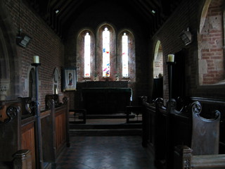
Farringdon - Church of St Petrock and St Barnabus (Listed Grade II*) - The chancel, choir and altar


But, as mentioned in my previous blog post, there is something that makes me smile. Apparently the Exeter born historian William George Hoskins opinion of this church, was to describe it as “hideous”. I think that a bit harsh. This opinion has always been quite the opposite to my reaction. I do believe the people of Farringdon have taken this on the chin, and now wear this as a sort of rather perverse badge of honour. It’s said, there’s no such thing as bad publicity.


Woodbury Common 001
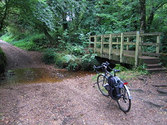
Woodbury Common - short off-road section through the woods

I didn’t stay too long at Farringdon Church, nor did I take many photos. If you wish to see more of this church, I recommend you visit my previous blog of 2014 (link above). I took a quick stroll around the church to savour its atmosphere, and then found a wall on which to perch as I ate my lunch. I then set off cycling on the next leg of my journey to East Budleigh.

The cycling this far had been relatively easy along country lanes with gentle inclines. Now my way started to climb a little more steeply as I approached Woodbury Common. A short section of this route over the common was along a rough track, which did slow my progress. It wasn’t long however before I began the descent along a country lane into East Budleigh.

Sir Walter Raleigh, East Budleigh 001
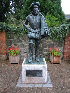
Inscription: 'Sir Walter Raleigh (1552-1618) Unveiled by HRH The Duke of Kent K.G. - 9 February 2006'

East Budleigh in a nutshell: Without doubt East Budleigh’s biggest claim to fame has to be that Sir Walter Raleigh (1554-1618) was born just down the road at Hayes Barton. Apparently, ‘East Budleigh was an important settlement until the Otter ceased to be navigable.’ At the crossroads is a pillar (photo), ‘Of brick, with a rectangular stone cap bearing religious inscriptions and a cross, erected in 1580 by the Sheriff of Devon who had to order the burning of a witch at the crossroads.’ – (Devon – Pevsner) [Amazon]

Quotation: ‘To put these [Exeter] executions into context, the last case in Scotland was as late as 1727 when a witch was executed by burning. There were also the notorious witch trials in Salem, Massachusetts, which resulted in the execution of 19 alleged witches in the course of 1692-3. Across Britain the overwhelming majority (around 80%) of those accused of witchcraft during the 16th-17th centuries were female, which is borne out by the statistics for the West Country.’ (Devon Witches) [Exeter Civic Society]

See: Forensic artist reconstructs face of Scottish 'witch' (BBC News – 31/10/2017)

Witches aside, I made straight for Salem Chapel (Listed Grade II*). But, before continuing here, let me briefly mention a place brought to mind when first I saw Salem Chapel. That place is Loughwood Meeting House (NT), which I’d visited in 2014 (see blog post: 15 March 2014 - Walk: Loughwood Meeting House (8.5 Miles)). The austerity of these two places is stark. Stripped of all the usual ornamentation typically found in a church, these places seem to represent the elemental quality of devotion. And, as much as I take pleasure in the ostentatious decoration of traditional churches, I am equally charmed by the rawness of dissenters’ chapels such as these. The desire of the people to pare back the pomp and dross and re-vitalise from core belief must surely evoke sympathy. So, what is the history of Salem Chapel?

Roger Conant (colonist) - By wagner51 (Photo by wagner51) [GFDL (http://www.gnu.org/copyleft/fdl.html), CC-BY-SA-3.0 (http://creativecommons.org/licenses/by-sa/3.0/) or CC BY 2.5 (http://creativecommons.org/licenses/by/2.5)], via Wikimedia Commons
Roger Conant (colonist) [Wikipedia] - Transcription of plaque: 'Roger Conant Born 1592 - Died 1679 The first settler of Salem, 1626 -:- "I was a means through grace assisting me, to stop the flight of those few that then were here with me, and that by my utter denial to go away with the, who would have gone either for England, or mostly for Virginia"'

The name, Salem Chapel, when first I came upon it intrigued me, as I was aware of the name Salem from the play The Crucible, by Arthur Miller, about the Salem witch trials, which I’d studied many, many years ago, and once seen in London. And, yes, there is a connection between the Salem, Massachusetts, USA, and this Salem Chapel, East Budleigh, as unlikely at that might seem. The explanation is given in a caption on a noticeboard to be found in the Assembly Room: ‘Roger Conant lived in the Mill House [East Budleigh] that stood near this car park. He and his brother Christopher sailed for America in 1623 and with his followers founded the town of Salem, Massachusetts, where a statue of his stands. His descendants still keep in touch with East Budleigh.’ Roger Conant, however, had no direct connection with this chapel, since it was built later (1719).

What I did find interesting, upon further research, was the connection of witches between East Budleigh and Salem, Massachusetts. Much of Salem town’s cultural identity reflects its role as the location of the infamous Salem witch trials. To discover upon subsequent reading (see mention above) that a witch was burnt at the stake in the centre of East Budleigh, makes for a strong historical theme connecting these two places. Exeter, my home town, is also significant in this respect, in that it notoriously, was the last place in England in which a group of witches were condemned to death, by the infamous Judge Jefferies, for practising witchcraft.


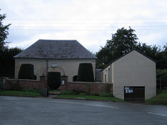
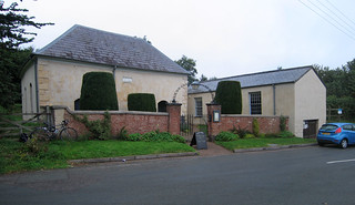
Viewed from the outside, Salem Chapel and its Assembly Room could easily be passed without a moment’s notice. Perhaps taken to be a couple of farm outbuildings. The pillared gateway to the chapel with iron trellis arch and the yew hedging  perhaps being the only visual clues that here is something more than a couple of utility buildings, although Pevsner says ‘eye-catching’ of the outward appearance (eye of the beholder perhaps?).


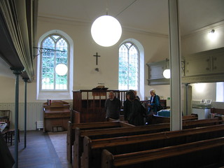
The interior is striking, in that it is a large open space, with the roof supported on a central iron pillar. It is airy, simple and elegant. The balcony, along three walls, is supported on slender iron pillars. The first floor box pews are possibly original, the ground floor pews a later addition. The central clock on the rear gallery is placed just as it is at Loughwood Meeting House. The total seating capacity is quite large. The solitary cross above the altar is about the only other decoration in the chapel. It is beautifully unpretentious.


I mentioned my curiosity regarding the derivation of the name Salem to the the lady serving tea in the Assembly Rooms. I asked if it was Biblical, as it seemed possibly so to me. The name Salem is Arabic. The Biblical Salem ‘is traditionally identified with Jerusalem [Wikipedia]. There are numerous places named Salem all over the globe. There is even a Salem in Cornwall.

WP_20170910_16_25_46_Pro
[Budleigh Salterton]: Shingle beach and diaphanous clouds


On leaving Salem Chapel, I returned to the centre of the pretty village of East Budleigh. From there I picked up a track rising above the village. The track was rough and rutted and a little muddy, so progress was slow once again. It wasn’t long before I joined a lane and the going became easy. I then made quick time down to Budleigh Salterton on the coast. The sun was making its best efforts to put in an appearance.

Budleigh Salterton 006
[Budleigh Salterton]: At this point a signed Permissive Path connects the road out of Budleigh Salterton with the disused railway cycle track that leads to Exmouth


Another shower of rain threatened, and therefore I wished to find a short route to the disused railway between Budleigh Salterton and Exmouth, which is now a cycle track, so as to be quickly on my way. There appeared to be a connecting path at the top end of Budleigh Salterton. My first choice [OS on DCC] was marked as ‘Path closed’ [OS on Bing Maps], but continuing up the hill a little further, I found this Permissive Path that led down to the cycle trail.

On approaching Exmouth, time had run on, so I didn’t linger. I picked up the Exe Estuary Trail and began my return journey in the direction of Exeter.

Topsham 001
[Topsham]: A short break near the Goat Walk on the ride home from Exmouth to Exeter


As I reached Topsham, the rain showers had cleared, and a lovely sun shone across the waters of the estuary. I paused for a quick snack and photo before embarking on the last leg of my journey home.

It’s not every day that a person out on a bicycle ride gets to see two very interesting Grade II* listed churches. It’s important to recognise the significance of that all-important ‘*’ (star) in the listing. A Grade II* listed building is very nearly Grade I, and there aren’t that many of them, therefore they can be regarded as nearly as noteworthy as Grade I buildings. It is my view, that they are always worth a visit.

Physically, it had been quite a demanding day, and come the end of my tour I was quite exhausted. The choice of my road bike had been a good decision, as I had travelled quite quickly and with relative ease.

The Witch 003a
The Witch, occasionally seen flying about my garden

And, so, finally, the last word goes to the witches and their witchcraft, a recurrent theme of my story today. Oddly, as much as witchcraft is despised, it seems to me, rather perversely to arise from an intrinsic human need for magic in our lives. The sense that the prosaic is not nearly enough for us, and that we need to fill our lives with greater mystery and meaning. I am reminded of the seemingly hysterical words uttered by Blanche DuBois from the play A Streetcar Named Desire by Tennessee Williams, when towards the end of that play she says, “I don't want realism. I want magic!” The question we have to ponder is, is that a streetcar that is en route to “Elysian Fields”. Sadly there was a malign and pernicious nature to the witch trials. Let’s spare a thought for the witches (past and present) this Halloween.

Walk Statistics:

Total Distance: 47.4 km / 29.4 miles
Moving Time: 4hrs 11min
Stopped Time: 52min
Total Ascent: 667 metres
Maximum Elevation: 164 metres

Buses: (none)

Saturday, 9 September 2017

09 September 2017 - Walk: Tiverton Leat Perambulation (6.3 Miles)

Synopsis: An organised walk from Coggan’s Well in the centre of Tiverton to the source of the leat that supplies the well. Well supported, with 580 walkers completing the route. I have the certificate.

GPS Tracklog Download (.gpx) Microsoft OneDrive -:- Google Drive
 
 
*** Please note, sections of this perambulation are not a dedicated public right of way ***
 
Tiverton Leat Perambulation 001Tiverton Leat Perambulation 004Tiverton Leat Perambulation 010Tiverton Leat Perambulation 019Tiverton Leat Perambulation 024WP_20170909_14_18_25_Pro
(selection of photos from Flickr photo set – use link above to view album)

My ex-colleague Gill, who lives in Tiverton, told me of this forthcoming event months ago. I said at that time, it sounds interesting, and we agreed that I’d join her to do the walk together. Gill’s sister Diane also joined us for the initial stage, as far as the brief halt at the Waterworks at Allers.

A little history first. The Perambulation of the Town Leat is a traditional mediaeval custom, also known as water-bailing, that takes place in the town of Tiverton, once every seven years. The event commemorates and claims the gift of the town's water supply in the 13th century from Isabella, Countess of Devon. Isabella is an interesting character. Thought to have been the wealthiest most powerful woman in the country at the time. The granting of the Tiverton Leat was, I presume, a form of noblesse oblige, in the words of Nancy Mitford. Isabella is the countess that gives Countess Wear, in Exeter, its name. Her primary residence was Carisbrooke Castle (EH), on the Isle of Wight. Her mother, Amicia, founded Buckland Abbey (NT). I don’t know if a likeness of Isabella exists, but this photo shows what is said to be a possible likeness of Amicia, a sculpted portrait on the walls of Buckland Abbey. Today, the bloodline and title Earl of Devon resides with the Courtenays of Powderham Castle.

Tiverton Leat Perambulation 002
[Tiverton]: Coggan's Well, Fore Street

Coggan’s Well, a small trickle of water, bubbling to the surface in Fore Street, Tiverton, was the start point of the walk. A band played and a town dignitary made a proclamation of what was taking place today and the significance of this historic tradition and the right of the people of Tiverton. There was, within the crowd today, a great sense of being part of 800 years of history. The way was initially slow, as we squeezed through a narrow alleyway beside the pannier market.

Tiverton Leat Perambulation 005
Tiverton]: Castle Street


The way then opened up a little, as it follows a course down the middle of a road, by the town’s Masonic Lodge. This is a very picturesque part of Tiverton, and its lovely to see the water course has not been lost in a culvert, as is typically the case. Yes, there was a little rain, and an umbrella was a useful piece of equipment to be carrying today, but on we marched, unperturbed, in best English tradition.

Tiverton Leat Perambulation 009
[Tiverton]: The Town Leat courses through the gardens of a number of town houses


Apparently, written into the deeds of houses through whose property the leat flows, is a covenant, that allows the people to march through their grounds once every seven years. Although the leat has long ceased to be the towns water supply, it’s lovely that this old historic privilege survives in the laws of this country. The way we took did in deed pass through some attractive gardens of town houses.

We walked through suburbs and on into the countryside, passing the grounds of Knightshayes (NT), without actually seeing the property, just the Impey Walk entrance path. We passed Chettiscombe, a picturesque set of cottages by the leat. Climbing a lane for a short distance took us to the Aller Waterworks, which was another proclamation halt, and toilet stop (just the one toilet, so quite a queue!).


Tiverton Leat Perambulation 033
The procession snakes its way through the countryside


We were, by now, out in the countryside. The leat could still be seen wending its way through fields and woods, sometimes to our right, sometimes to our left. There was a great feeling of camaraderie, seeing the long snake of people curling its way into the distance. Odd thing was, everyone seemed to know everyone else. I, of course, was something of an interloper, but I think that went largely unnoticed.

Tiverton Leat Perambulation 036
The procession snakes its way through the countryside. At this point the leat had to be crossed (carefully)


There was mud, as there always is in the countryside, and crossing the leat had to be done with care. A couple of stiles caused quite a bottleneck, as people struggled to negotiate them. No one seemed in that much of a hurry; these 800-year old traditions have to be allowed to assume their own inexorable pace.

Tiverton Leat Perambulation 052
Gill, on guard at her post.


And so, finally, some tiring a little, we reached the source of the Tiverton Leat. It’s a fairly modest affair, just a corner of a field, with a metal marker stuck in the ground. But, of course, that was the place to stand and have our photos taken, our badge of honour. The post had been provided by a previous mayor of Tiverton, a Mr. A.T. Gregory. As the year on the post was slightly obscured by damage, I had to research the date. It would seem the post was erected in 1912.

Tiverton Leat Perambulation 055
The perambulation completed, revellers partied in the marquee to jazz music, with beer and pizza refreshment.


There was a marquee with a band playing at a nearby field, which is where all the leat-blazers congregated for beer and pizza. It had been a great experience, and lovely to see the community coming together like this, and having such fun. Still it rained. Gill and I were grateful for the lift her sister Diane offered us, to get us back to Tiverton. I was soon on the bus, and traveling home once again.

Walk Statistics:

Total Distance: 10.1 km / 6.3 miles
Moving Time: 4hrs 54min
Stopped Time: 47min
Total Ascent: 212 metres
Maximum Elevation: 482 metres

Buses: D & 55