Synopsis: Trip inspired by desire to take a look around Maker Heights Barracks, a school camp of my father’s in the 1930s. Includes a ferry journey from Cawsand to the Barbican, Plymouth. Great day!
This was a fairly early start for Mum and me. We were travelling by train to Plymouth from our local Digby & Sowton rail station. Our trains down, and in fact all the trains, buses and ferry today, were very punctual. Arriving in Plymouth, we had an hour and ten minutes to spare before our bus was due, so we sought out the station café for tea and a muffin.
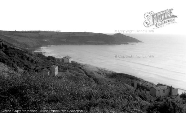
We caught our bus just outside Plymouth rail station. It took us through part of Plymouth before dropping down to the Torpoint ferry. The ferry took us across the River Tamar to Saltash, in Cornwall, across the border and into the wilds. Slowly the bus climbed through the streets of Saltash, out into the countryside, before swooping south down to the coast. This next stretch of our journey was one of our day’s ‘bonus’ sections. We peered out on the broad sweep of Whitsand Bay, and in the distance we could see the headland of Rame Head with its little chapel. Shown below, alongside the photo of Mum on the bus, is an historic photo showing a few of the holiday chalets that dot the steep-sided shore of Whitsand Bay.
The bus then dropped towards Cawsand and Kingsand, but rather than leave the bus at this point, Mum and I stayed on board. The bus took us out to Millbrook and back, before climbing the hill to Maker Heights, which was our chosen bus stop. At this point, on the junction with Maker Lane, there is this superb view out over Millbrook.
Mum and I then proceeded along the track which led us in the direction of Maker Barracks. That’s what it continues to be named on the map, although it has long since ceased to be a barracks. It is today known as Maker Heights Centre.

I noticed an array of Nissen Huts on our left as we approached Maker Heights Barracks. I wonder if this might have been where Dad was billeted on summer camps from Central School, Exeter. I wasn’t sure when Nissen huts came into being, but on looking this up (where would we be without Wikipedia?), I find that these were ‘originally designed during World War I. This makes it possible that the huts we saw today were in place in 1930, and could have been the school summer camp. They don’t seem to have much in the way of windows.

The ‘Guard House, Boundary Wall and Attached Ancillary Buildings’ and the ‘Barrack Block’, at Maker Heights Barracks, are both Grade II* Listed, which signifies that they are deemed to be of some considerable importance. The Barrack Block is described in its listings as, ‘This is the most complete and unaltered example in England of a small garrison barracks from this significant period, and includes many of the ancillary buildings within a defensible site.’

I believe the buildings sat derelict and disused for a long time, and the hope was always to find a use for them, to bring in some money to help with the upkeep of the buildings. I noticed a number of art galleries had moved in, and that generally things were looking pretty good. There wasn’t the complete air of abandonment I was half expecting.

At the back of the main Barrack Block, along the north-east wall, there exists the former straw store, wash house, stables, gun shed and magazine. The fact that the site is so complete, with all these out buildings remaining, makes this a treasure of a historic survivor.

I believe the main building we see today is the Barrack Block. And I think the way we see it today isn’t far removed from how it has always looked, which is refreshing, particularly in this age of the ‘make-over’. I believe the buildings are of early to mid nineteenth century construction. To the rear of the Barrack Block there are external steps, which appear to be original, leading to the upper floor of the building.

To the north-east of the Barrack Block is to be found the Guard House. This is now in use as an art gallery. Beside it, to the south-east, there is a rather primitive looking toilet block. I think this could be as far as it goes as regards campsite facilities. But then, this is described as ‘camping as it should be’, and when one sees the glorious position of the site, it’s easy to see their point.
The Maker Heights Barracks seems to operate today under the banner, Maker Festival & Maker Camps, and has its own web site.

The lone building to the south-west is described as the coal house and linen store. An odd combination, considering the dust from the coal dust, but probably the building was partitioned. The chimney suggests a fireplace, perhaps to keep the linen aired.
The book Plymouth in the Twenties and Thirties by Chris Robinson speaks (p.139) of ‘School groups also went camping at the old military encampment at Maker with its huts and big green spaces’. This re-enforces the fact that Maker Heights Barracks was definitely a popular school summer camp during the time that my father went on a summer camp here.
Time was marching on, and thoughts of lunch were paramount, so Mum and I walked on, following the track through the camp site, and then beginning to descend off the hilltop. As we went, somewhat shrouded in vegetation, there were what I presume to have been defensive positions dotted on the coastal aspect of the site.
Crossing a lane, we picked up a way that was clearly signposted as a public footpath. This started well enough, but became fairly steep and quite uneven. It was also very enclosed by the high hedgerow, so, in hindsight, I’m not convinced this was necessarily the best route to have taken. I think, given the chance to make this walk again, I’d choose to walk north-east at the lane and pick up a path that would have dropped us down to the coastal path, which goes through what is rather quaintly named Minadew Brakes. I think the going might be easier than the route we chose today, and the views possibly better too.

I had checked out possible eating venues in Kingsand before setting off today. There seemed to be a number of favourable possibilities, of which I thought we’d try The Devonport Inn. I’d read that it could get busy, but being down on the seafront, it seemed to have the most enticing views going for it, so I thought it worth a try. As it happened, we immediately found a small table that suited us fine. It wasn’t long before we were tucking into our excellent Cumberland Sausage and Mash. The sun streamed in through the window, there was a buzz of people going to-and-fro, and numerous people were in high spirits, as a wedding seemed to be taking place in the village.
On finishing our lunches (time at The Devonport Inn 12:55-14:00), we had plenty of time to amble as we pleased, as our ferry from Cawsand to Plymouth was not due until 15:30. We often found ourselves merely leaning on the railings gazing out to sea and generally watching people milling about. It was warm, sunny, and with just a gentle breeze blowing. It couldn’t have been better.
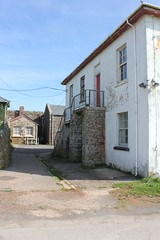
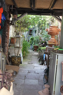
We walked to the eastern edge of Kingsand, the last stretch of which Mum held back from following, as it involved my hopping across rocks. From the furthest point I reached I came upon a sandy stretch of beach with hardly a soul on it. Apparently, each summer, there are erected a number of beach huts located at Sandway Beach, just a little further along the coast towards Picklecombe Fort. I noticed that a number of the properties in Kingsand were for sale, and inviting they looked too. The one pictured here, had the most delightful ‘back yard’.

Mum and I then backtracked past The Devonport Inn once again and into the village centre. We passed the tower which got a heavy battering during the winter storms of 2014. I believe the tower needed considerable repairs and work to protect it, following those storms.
A bit further along, we came upon the Halfway House. And on from that, we saw Boundary House. The preoccupation with place stems from the time when this was the boundary between Devon and Cornwall. At one time Kingsand was in Devon, and Cawsand was in Cornwall. I understand there was considerable rivalry between the two. Whether that persists to this day I do not know.

A short climb from here and we were at a promontory, buildings all about looking down on the beach at Cawsand. The sea was the most wonderful azure colour. It could have been the Mediterranean. We watched a woman, who was obviously a seasoned swimmer, take her plunge. If I’d had my swimming costume, I could have been tempted. As we watched, we could hear a drumming nearby. Not sure what it was, we approached Cawsand’s village centre.
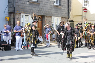
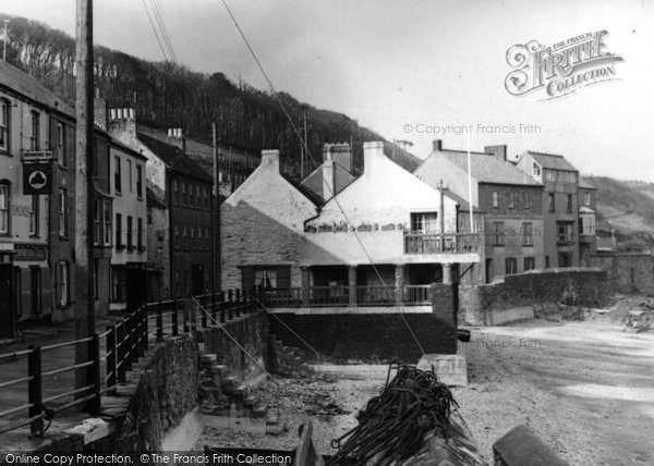
As we dropped down into the centre of Cawsand, all became clear. A large band of raucous Morris Dancers had taken over the village centre, and were entertaining the crowd. Dressed in black, with faces painted black too, they had a rather eerie look to them. But the evident fun the dancers were all having easily quelled any sense of alarm at their appearance. The group were performing in the Square, seen here in 1949.

After watching the Morris Dancers for a while, Mum and I dropped down to Cawsand beach. There is a small shelter on the beach for those waiting for the ferry (The Cawsand Ferry). Hardly in need of a shelter today, Mum and I found ourselves a bench on which to sit. I began to fidget, so I strolled off across the beach and climbed on the rocks at the furthest reach, which proved a good vantage from which to take a few photos.

The time was approaching 15:30, the time our ferry was due, and a tiny red dot appeared on the horizon. Slowly our ferry came into sight. A small queue had formed on the beach, so Mum and I went to join them. It’s not a big ferry, and the rather basic wheeled jetty looked quite flimsy, but with a little help from ship hands, we were all soon boarded.

This was to be another of today’s ‘bonus’ elements on our trip today, as we were to get some fine views of the coast along Cawsand Bay. And we also had our first close-up views of the breakwater at the mouth of Plymouth Sound and Drake’s Island. And in addition to all that, we both had our first sea view of Plymouth Hoe, the Tinside Lido, and the Citadel. It proved a really interesting ferry crossing, and we were so pleased we had made this crossing of the bay by boat.
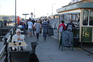
On arriving at the Barbican we sought out a little harbour side vendor selling ice creams and hot tea. We were soon in the possession of a cornet and cup of tea each. We found a table overlooking the marina and sat back and relaxed, and continued our people watching of the day.

Whilst Mum and I sat and ate our ice creams and drank our tea, this most amazing car sailed by. I just had to grab a photo or two. I’m certainly no aficionado of cars, so I had to look it up on arriving home. Apparently it is a 1958 Oldsmobile Super 88 Holiday coupe. I think it’s more a work of art than a car. It was certainly capturing people’s attention down on the Barbican. ‘Arrive in Style’ the advertising caption says. I think it would be possible to live up to that in this car. Only thing is, surely you would have thought it might have been a Plymouth in Plymouth.
There is a taxi rank on Plymouth Barbican from which we caught a taxi back to Plymouth railway station. It had been good to see Maker Heights Barracks today, the place my father stayed at during a school summer camp in the 1930s. It was easy to see why it had made such a lasting impression on him, one that stayed with him all his life.
Trip Statistics:
Buses: (32): 10:25 – 11:46
… Plymouth Railway Station [Pennycomequick] to Anderton, Maker Heights Centre £3.00
Trains: Digby & Sowton / Plymouth off-peak day return with Devon and Cornwall railcard £6.55/person
… Normal ticket price without railcard discount (33%) would have been: £9.90/person
Train out: 07:34 – 09:16 (1hr 42mins) – one change: St David’s, Exeter
Train return: 17:25 – 19:00 (1hr 35mins) – one change: St David’s, Exeter
… Cawsand to Plymouth Barbican: £4.00/person
Taxi: Plymouth Barbican to Plymouth railway station: £5.40







No comments:
Post a Comment