Saturday, 18 June 2016

Jo Cox MP

A fund has been set up in honour of the life of Jo Cox MP so tragically and senselessly killed.


Jo Cox's Fund - [Go Fund Me]

'The Sunday Times reports that her [Jo Cox's] sister Kim Leadbeater borrowed one of Mrs Cox's favourite phrases when she urged people to focus on "that which unites us not which divides us".'
 - [Sunday Times - 19/06/2016]
BBC News - Newspaper Headlines - (19/06/2016)

Tuesday, 7 June 2016

07 June 2016 - Walk: Torquay to Totnes (13.7 Miles)

Synopsis: A repeat walk with ex-colleagues following parts of the John Musgrave Heritage Trail. Includes brief visits of Berry Pomeroy Castle (EH) and Totnes Castle (EH).

GPS Tracklog Download (.gpx) Microsoft OneDrive -:- Google Drive
 
 
Statistics and tracklog overlay on Open Street Map (OSM) and Open Cycle Map (OCM) Runtastic
 
Torquay to Totnes 001Torquay to Totnes 003Torquay to Totnes 006Torquay to Totnes 012Torquay to Totnes 015
(selection of photos from Flickr photo set – use link above to view album)

This walk was undertaken with a small group of ex-colleagues of mine. We wished to do a public transport based walk, and I offered up this walk, one that I was familiar with, knowing it to be a very interesting linear walk, only achievable without a car. The previous occasions I’d done this walk and blogged in 26 April 2008 - Walk: Torquay to Totnes (9.4 miles) and in 18 June 2015 - Walk: Torquay to Totnes - John Musgrave Heritage Trail (9.0 Miles). The only significant difference to my previous walks being that this time, rather than use buses, we opted to use trains. Both modes of public transport are quite possible. Trains are a little more efficient, and provide better options for returning from Totnes, with direct services running more frequently than buses and later into the evening. Please see further details of trains used and the tickets on which we travelled below in the Walk Statistics section of this blog post. The train times out I’ve given from Polsloe Bridge, which is the station I used; I was joined by my fellow walkers at St Thomas railway station. I was walk leader for the day, navigation being my responsibility. The walk takes in Berry Pomeroy Castle (EH) and Totnes Castle (EH).

The day started a little overcast and damp, but by the time we’d reached Torquay Station (9:49) the weather was appearing to clear. We strolled out to the coast and paused a moment at Corbyn Head to look out over the tranquil sea of Torbay. It was still quite early and relatively sleepy.

Torquay to Totnes 004
Cockington Court - Gamekeeper's Cottage

We then picked up the path that wends its way from Livermead Sands through a valley following the stream that flows through Cockington. I took us past the picturesque series of lakes which form part of Cockington Court. Plenty of bright colour was provided by the rhododendrons that line these lakes. We passed the Gamekeeper’s Cottage, a beautiful thatched cottage tucked in under the trees. This building, having laid dormant for years, is being renovated and will become accommodation for six estate volunteers when made ready. Great to see the building looking so resplendent and back in use once again.

Torquay to Totnes 005
Cockington Court - Church of St George and St Mary (Listed Grade II*) –[Historic England List]


We then walked towards the manor house, branching to the left to follow a path that took us up to the Church of St George and St Mary (Listed Grade II*). This is a lovely little church, full of warmth and charm, and perhaps a little surprise tucked away here, adjacent to Cockington Court manor house.


Torquay to Totnes 007
Cockington Court - the craft workshops housed in the old stables


We then strolled through the walled rose garden to what was once the stable block. These have been converted into craft studios. There is a blacksmiths workshop, and a glassblower. The blacksmith wasn’t about, but glassblowers were going about their business, attracting a small crowd of onlookers, with us playing our part in that.


Conscious that we still had plenty of walking to do, I led us out the back of Cockington Court, picking up a public footpath that climbed steadily along a track, eventually jettisoning us into fields. By now the day was starting to warm nicely, although the air was humid and sticky making the walking quite demanding.

Crossing the busy A380 with a good deal of care, as the traffic was heavy and travelling very fast. We were relieved to complete the short section by this road, and be once again in the quiet lanes heading in the direction of Marldon. We were only 3.6 miles into our walk (11:50), but already it felt as if we’d left the bustling seaside resort of Torquay far behind. We dipped down the hillside into Marldon and then climbed the steep lane out the other side, the steepest ascent of this walk.

Torquay to Totnes 008
A view along the way of our walk towards Berry Pomeroy Castle

Catching our breath at the top of the hill, we then left the lane via a footpath to our left, and were soon out crossing fields with wide expansive views of Devon countryside all around.

It wasn’t long before people were saying they were getting hungry. I said that I’d like to make Berry Pomeroy Castle (EH) for lunch, if we possibly could. The little suppressed grumbling arising from the group I chose to ignore, and on we walked. In one field a number of bullocks were curious and came to watch us walk by. A little further on we passed Loventor (Listed Grade II), originally a Tudor manor house which was later extended during Georgian times.

Torquay to Totnes 009
Berry Pomeroy Castle (EH) - [English Heritage]

After covering 6.1 miles into our walk (13:10) we reached Berry Pomeroy Castle. We talked briefly with the English Heritage warden in the ticket office about the ghosts that haunt the castle (which apparently are played down by English Heritage), we entered through the gatehouse. We chose a grass bank on which to perch ourselves, which was where we settled down to eat our lunches. People were happy once again. We were now about half way into our walk.


After lunch we took a little time out to stroll around the castle. English Heritage do supply a very good audio guide, but we felt we couldn’t spare the time today. Berry Pomeroy castle led a double life, once as a fortress, and then converted into a manor house. It sits high on a rock promontory with views over what was once its walled deer park. It is deemed to be the most haunted place in Devon. We saw no ghosts today. We did see birds that had nested in the chapel which we were unable to identify.

Torquay to Totnes 010
Berry Pomeroy Castle (EH) - [English Heritage]

Leaving the castle we back-tracked a little, dropping rapidly to the lake below the castle. From here we picked up a lane which is once again part of the John Musgrave Heritage Trail. Our way took us onto a track through woods. At this stage the walk is relatively level and easy going, if a little muddy in places. After a short stretch along lanes we picked up a track to our right that climbed quite steeply, passing a traveller’s site as we went. Continuing down a shallow valley, we were by now not far from Totnes, although Totnes remained tantalisingly out of sight. Because Totnes itself nestles in a valley, it is not seen before one finds oneself entering the backstreets of the town.

Torquay to Totnes 013
[Totnes]: Totnes Castle (EH) - [English Heritage] - the walking party


So, there we were, soon upon Totnes Bridge. The sun was shining and the day was hot, and we were pretty tired. But, undeterred, we ploughed on up the main street of Totnes with our aim of obtaining Totnes Castle as our next objective. Totnes Castle is a classic motte-and-bailey castle, one of the earliest to have been built in this country by the Normans. From the ramparts extensive views are to gained over Totnes, the surrounding countryside, and down the River Dart.


And so, that completed our walk today. We descended from Totnes Castle in the direction of Totnes Railway Station, a mere 10 minute walk away, having walked the full 13.7 miles (17:28). A brief wait of 20 minutes and we were aboard a train hurtling towards our home town of Exeter. To complete the day we walked from St David’s station to the Mill on the Exe pub, found a table by the river, and ordered our supper. It was the perfect way to round off a good day’s walking.

Walk Statistics:

Total Distance: 22.1 km / 13.7 miles
Moving Time: 5hrs 10min
Stopped Time: 2hrs 18min
Total Ascent: 564 metres
Maximum Elevation: 146 metres

Buses: (none)
Trains: Polsloe Bridge to Torquay (out) / Totnes to Exeter St David’s (return)
Devon Day Ranger with Devon & Cornwall Railcard: £6:60
…… Normal ticket price, without railcard discount (33%) would have been: £10.00

Train out: 08:47 – 09:49 (1hr 2mins) – no changes
Train return: 17:51 – 18:23 (32mins) – no changes (from Totnes)

Monday, 30 May 2016

30 May 2016 - Trip: Tintagel

Synopsis: A trip to visit Tintagel Castle (EH) and Tintagel Old Post Office (NT) with Mum and sister-in-law. A lovely warm sunny day, the perfect day for the glorious views from this amazing location.

 
Tintagel Castle 001Tintagel Castle 005Tintagel Castle 008Tintagel Castle 012Tintagel Post Office 001Tintagel Post Office 005
(selection of photos from Flickr photo set – use link above to view album)

I noted from my English Heritage magazine that new interpretation panels had been introduced at Tintagel Castle. The small on-site museum and café had been refurbished too. I’d been thinking for sometime it would be nice to visit the castle when my sister-in-law, Christine, suggested a day trip out with Mum. I recommended Tintagel, and all of our small party were keen. And what a tremendous day it was too.

Tintagel and its castle are wonderfully situated on the north Devon coast. The location alone is worth a trip. Add in to the mix the Tintagel Castle (EH) (Historic Monument) and the Old Post Office (NT) (Listed Grade I), and you have all the ingredients for an excellent day out. And on a glorious day like today, with warm sunshine in abundance, the place couldn’t have looked more splendid. It proved a busy place, but amenities were more than adequate for the surge of visitors falling upon the tiny village of Tintagel today.

I’ll keep this blog post brief. Tintagel is a fabulous place to visit, so don’t sit there reading this. Here are just a couple of photos of the two main attractions we visited today.

Tintagel Castle 003
[Tintagel]: Tintagel Castle (EH) - [English Heritage] - Island Courtyard

Tintagel Castle owes much of its reputation to the King Arthur legend, as this reputedly was the place of his birth. Since the story is an unfathomable mix of fact and fiction, everyone must make of it what they will. But, whatever the truth, it’s a great story, one that fires the imagination, especially of children. And what greater romantic location for such a story could there be than Tintagel Castle? Just beware the children and their plastic swords as you scale the narrow path to the ramparts. Do I hear those immortal words, “Once more unto the breach, dear friends, once more”?


Tintagel Post Office 018
[Tintagel]: Tintagel Old Post Office (NT) - [National Trust] - the front of the building, viewed from the road


Tintagel Old Post Office is a sight to behold. There doesn’t appear to be a straight line in the building. It has a Middle-earth quality about it, and you half expect to bump into a Hobbit. The height of the doors and ceilings in the building would also suggest this. It is quaintness personified. The building is an early acquisition of the National Trust (1903). Thank goodness this little gem of a property has been preserved, in all its glorious 600 year history, to this very day. It is a window on the past.


I end this post with a little family story as told by my rather wayward mother. Apparently, so my mother tells me, Tintagel was, in her youth, always a popular destination for days out by bus. So it was that on a summer’s day many years ago my mother travelled with her parents on a day-trip to Tintagel. On entering the Old Post Office, people could be seen scribbling their names on one of the whitewashed walls of the building. The use of part of an historic building for graffiti probably strikes us as slightly improper today. Anyway, as everyone else was doing it, my grandparents wrote their names, and then encouraged their daughter, my mother-to-be, to write her name. A couple of weeks later my mother received a fine in the post. She is convinced she is the only person to ever have been fined for such an action, and puts it down to the unfortunate legibility of her writing. Today (thankfully) we could find no evidence of this early transgression on the part of my mother. If, wherever your perambulations should take you, you happen to come across the name Jean Rockett scrawled upon a wall somewhere, that will be my mother.

Saturday, 14 May 2016

14 May 2016 - Walk: Bovey Tracey (9.0 Miles)

Synopsis: A walk from Chudleigh Knighton to Bovey Tracey. Includes Chudleigh Knighton Heath and Little Bradley Ponds. Also a glimpse of Blue Waters Pond, previously a coal (lignite) mine.

GPS Tracklog Download (.gpx) Microsoft OneDrive -:- Google Drive
 
 
Statistics and tracklog overlay on Open Street Map (OSM) and Open Cycle Map (OCM) Runtastic
 
Bovey Tracey 011Bovey Tracey 022Bovey Tracey 025Bovey Tracey 035Bovey Tracey 051Bovey Tracey 056
(selection of photos from Flickr photo set – use link above to view album)

Spontaneous walking. I think that best describes today’s walk. I normally map out my route in fine detail and load it to my GPS, as this makes walk navigation on the day very easy. But today, I simply glanced over Ordnance Survey mapping, and checked bus times out of Exeter, and set about my walk. In part, I wanted to allow myself the freedom to explore just exactly where I could and could not walk, which wasn’t entirely evident from maps. I had in mind two features that I’d like to include in the walk, Devon House and Blue Waters Pond, both of which I explain below.

Recently I’d visited the heath lands in this area on a walk with some ex-colleagues of mine. We didn’t have time on that walk to explore all that I hoped (too much talking and not enough walking I’m afraid). So, at least in part, motivation for today’s walk arose from that previous visit.

Bovey Tracey 001
[Chudleigh Knighton]: The Claycutter's Arms (was there only one claycutter?)

The bus from Exeter that I travelled on dropped me as planned at the Anchor Inn bus stop in Chudleigh Knighton. The first observation that I made today was, there’s no Anchor Inn here. It had been demolished. I could recollect vaguely what it had looked like, and I remembered noting that it looked a little run down. Well, it is now entirely run down, just a pile of rubble. Apparently pubs are closing at a great rate right across the country. I passed this, the Claycutter’s Arms, in Chudleigh Knighton, with seemingly a better fate.

Bovey Tracey 002
[Chudleigh Knighton Heath]: Information board showing Ant Trail


I followed the road out of sleepy Chudleigh Knighton. On the outskirts of the village, there was an information board for Chudleigh Knighton Heath which showed me where I was and the direction in which I needed to walk. Apparently, I would be walking on the Ant Trail. There are some rather peculiar ants on the heathlands in this area, so I’m led to believe. There are way-post markers that dot the trail, so route finding was easy.

Bovey Tracey 005
[Chudleigh Knighton Heath]: Connecting path to the left of my walk along the Ant Trail


I reached a point where there seemed to be a connecting path to my left that I thought might exist. This path I assumed to connect with the previous walk I’d done with my ex-colleagues a few weeks ago. I decide to explore the path to see if I was correct in that supposition, with the intention of walking out and then returning to this point.

Bovey Tracey 008
[Chudleigh Knighton Heath]: Quiet and peaceful, and the place to myself


And yes, just as I expected, the path I followed led me to a point that connected with my previous walk. It was lovely and peaceful out on the heathland, with not a soul about. The trees all about in the bright colours of their new foliage. It’s a great time to be in the country.


Bovey Tracey 012
[Chudleigh Knighton Heath]: Lots of Early Flowering Purple Orchid (Orchis Mascula) [Wikipedia]


Returning to the point of my path of primary intent, I continued along this, heading roughly in the direction of Little Bradley Ponds. This is a nature reserve managed by Devon Wildlife Trust. I was approaching from a new direction requiring me to explore navigation options as I went. Part of the way could be walked along a path on the edge of woods, but after a while it was necessary for me to return to the road and walk, with extreme caution, down hill to where the entrance to Little Bradley Ponds was to be found.

Bovey Tracey 014
[Little Bradley Ponds - [Devon Wildlife Trust]]: Still waters


Choosing the left lake to explore first, I set off on the perimeter path that encircles the lake. One of these lakes is apparently an old ball clay works. I think it is not this first lake, but the lake across the road from it. The path around that other lake looks white and appears like clay.


Bovey Tracey 016
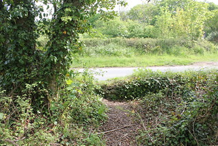
[Little Bradley Ponds - [Devon Wildlife Trust]]: Possible point of entry to the ponds, but involves scrambling over a low wall

Part way around the lake I was encircling I noted a path off to my left. I decided to explore where this led. There are no clues on maps as to where this path might lead. Climbing along this path for a while I eventually discovered that it led out to the road along which I had just walked. There is no ‘official’ entry onto this path, and in fact there is a wall at the point where the path connects with the road, but is clearly used by some people as an entry to the lake. If I’d known it was there, and was prepared to climb the wall (about 0.8 metre high) I could have avoided the need to have walked some of the road I’d just traversed.

Bovey Tracey 020
[Little Bradley Ponds - [Devon Wildlife Trust]]:


Regaining the path around the lake, I was now at the highest point along this path. The path is narrow and winds it’s way through small trees and scrub, but is easy to progress along. I was soon descending once again, and it wasn’t long before the lake, or should I say pond, came into sight once again.


Bovey Tracey 025
[Little Bradley Ponds - [Devon Wildlife Trust]]: Lots of Water Lilies (Nymphaeaceae) [Wikipedia]


Completing the circuit of this first lake, I was back at the road where I could enter the opposite lake. This lake, slightly larger than the first I’d walked, has a perimeter path like the first. Part way into this walk I once again noticed a path off to my left, and once again, decided I’d like to explore. I had noted from having previously perused a map of this area, that there was another lake nearby. I came upon a stream to be negotiated via a collapsed bridge, but once across this, another lake came into view.

Bovey Tracey 029
A pond that is close to Little Bradley Ponds.

I’d previously visited the first two lakes I mention here, but this lake I’d not seen before. It was clearly a lake for fishermen, as all around it can be found numbered fishing stations. I followed the path in a south-easterly direction eventually reaching a path intersection point with a path leading off left across fields. At this point I realised that I was on a public footpath I’d seen earlier on the map. There is a sign on the lake perimeter path that says fishing permit holders only are permitted to proceed further along this path. I was happy to return the way I came, as I now wished to follow this public footpath in the direction of Bovey Tracey.

Entering Bovey Tracey I picked up Combe Lane, which in turn led me to a road named Devon House Drive. This left me in little doubt I was headed in the right direction. The ‘drive’ is now lined with bungalows. As I walked along this road Devon House and its grounds came into sight. I could immediately see how similar this building was to other such Victorian institutions of this period, with a sturdy looking building located in grounds planted with various cedars. Quite peaceful and elegant in its own way.


The building was previously known as Devon House of Mercy. It was run by nuns, and was meant to be a sanctuary for ‘penitent’ or ‘fallen women’. A laundry service was operated from the institution. In many ways, I presume this to be not unlike the infamous Magdalene Sisters, the story of which was made into a film about ten years ago. I’d recently re-watched the film, which reminded me of the horrors practised at such inhumane institutions. I suppose that piqued my interest in visiting this place.


Devon House is now flats. One of the residents was decidedly unfriendly and asked me what I was doing. I explained I was simply walking through and taking a few photos as I went. Effectively, he told me to bugger off, despite my protestations, saying I was doing no harm. One of the last relics of the Miserable English so wonderfully portrayed by John Cleese all those years ago. Shame they don’t recognise themselves.

Bovey Tracey 043
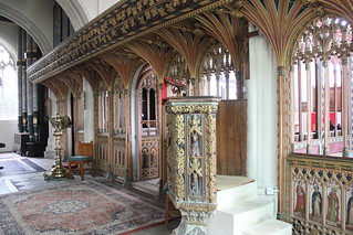
[Bovey Tracey]: St Peter and St Paul and St Thomas of Canterbury (Listed Grade I) [Historic England List] Fifteenth century rood screen and medieval pulpit

Picking up the public footpath that leads off from Devon House back in the direction of Bovey Tracey, I descended the hillside, and re-joined the road near to the parish church of St Peter and St Paul and St Thomas of Canterbury (Listed Grade I). I took a little time out from my walk to visit the church, as I usually do. It has an absolutely amazing rood screen. The pulpit is very impressive too.


Bovey Tracey 050
[Bovey Tracey]: St Peter and St Paul and St Thomas of Canterbury (Listed Grade I) [Historic England List] - water trough in the stone wall by the parish church


Outside the church I found myself looking for golden frogs. There is a small water trough set in the wall below the church, which today is dry. There is an ancient legend of golden frogs that surrounds this water trough, a delightful legend, which can be read about on the Legendary Dartmoor web site.


Bovey Tracey 052
[Bovey Tracey]: My picnic lunch spot, a bench by the River Bovey


I continued my walk, entering the main street of Bovey Tracey, busy today, in part because there was a local market taking place. It was just a little after midday and I was getting to be a tad hungry, not least because I’d had an early breakfast. I knew there was a park by the River Bovey at the lower end of town, not far from the old mill, that I thought I’d seek out. And, just as I had hoped, there on the banks of the river was the perfect park bench, an ideal stop for my lunch break. I sat and watched the grey flycatchers catching their lunch as I ate mine.

Bovey Tracey 054
[Bovey Tracey]: The Church of St John the Evangelist (Listed Grade II*) [Historic England List] - monument to 3 sisters (echoes of Macbeth here), who drowned on the River Nile in 1875 [link]

After I’d eaten my lunch I backtracked to the road bridge over the River Bovey. From here, a public footpath led me away from the car park and up the hill. A little way further and I came across The Church of St John the Evangelist (Listed Grade II*). Initially, although noting the pleasing aesthetics of the church, it had been my intention to merely walk by, when I noticed a substantial monument in the church cemetery. It immediately occurred to me that this was the monument that I’d been mistakenly looking for in the church of St Peter and St Paul and St Thomas of Canterbury, visited earlier.

Previous to my walk today I’d read the story of the deaths of 3 sisters (echoes of Macbeth here), Emily Gurney, b.1843, Lutterworth, Leicestershire, Rosamund Gurney, b. 1851, London and Mary Gurney, b. 1855, London (Ancestry Message Boards). They were daughters of Rev. John Hampden Gurney, Prebendery of St Paul's Cathedral. The sisters all drowned in the River Nile in 1875. Apparently a storm blew up and the boat they were on capsized. If you wish to read more of this story I recommend you visit the blog post ‘Russell Gurney (1804-1878) and the Melancholy Accident’ by Colin Salter. This includes an extract from the New York Sunday Courier for 30th January 1876 which recounts the story of this tragic accident.
Bovey Tracey 067
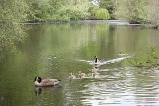
[Bovey Tracey]: Pottery Pond and Canada Geese

Moving on, I Picked up a public footpath that followed the banks of Pottery Pond. This, as its name implies, was a pond created to power the once thriving pottery industry of Bovey Tracey. This pond alone powered five water wheels. Today it is the tranquil preserve of ducks and geese. A family of Canada Geese with fluffy goslings waddled by as I too waddled on my way.


Bovey Tracey 075
[Bovey Tracey]: Blue Waters Pond - previously this was a lignite coal mine


The bigger pond that I was seeking out was that named Blue Waters Pond. I was curious to see this as it was once a working coal mine. At one time lignite, a low grade coal, was mined here, well into the middle of the 20th century. I suspected that I would only be able to glimpse the pond as I was fairly certain that unfortunately there is no public access to its shores. This was driven home to me by an ‘Only site residents allowed by this lake’ sign posted on the boundary to the lake. Still, I did at least manage to catch this view of the Blue Waters Pond.

Bovey Tracey 078
Templer Way running through the tranquil Great Plantation

At this point in my walk was on the Templer Way designated walk route. It was necessary for me to walk some length (about 1.4 kms) of this walk route along a road, which required some care. Eventually, near Belle-vue, the route left the road and entered woodland. This was a quiet tranquil place, a delight to walk through.

I was headed for Drumbridges Roundabout, as there are bus stops on this roundabout from where I would be able to catch a bus home. Unfortunately my timing wasn’t brilliant, as I’d have to wait nearly an hour for a bus. There was however a comfortable shelter in which I could sit and await my bus.

It had been not a very long walk, nor was it that demanding, but it had been a walk that had much variety in it. I’d achieved my various objectives for the outing, and had had a relaxing and enjoyable day’s walking. The countryside was looking crisp and fresh in its spring habit.

Walk Statistics:

Total Distance: 14.49 km / 9.0 miles
Moving Time: 3hrs 47min
Stopped Time: 46min
Total Ascent: 178 metres
Maximum Elevation: 75 metres

Buses: 39 & H